
Guest post by Michael Fagin
Most of the discussion of Mt. Everest weather revolves around when we will have that prefect weather window when the jet stream briefly shifts to the north and get reasonable summit winds, usually 20 mph or less occurs. This can occur briefly in early May but more common in the middle or the end of May.
The winds are of course key to any summit bid. Also important is to make sure you are done climbing before the heavy precipitation of the monsoon season starts. This is usually starts in June or can be in late May. However, there are occasions when a tropical depression forms south of Everest in early May, in the Bay of Bengal and these can be of great concern. These tropical storms bring an enormous amount of moisture inland.
One such storm, Cyclone Laila, formed in May of 2010 and brought 18 inches of water equivalent (460 mm) in a two day period in areas south of Everest. Fortunately the main impacts of this storm passed to the south and east of Everest. The type of storms in the Bay of Bengal and the Atlantic are listed in the table . You can also look at satellite imagery to see the extent of moisture field from cyclones.
Storms by Category
| Winds under 32mph | Winds 39-54mph | Winds 64-72 mph | Winds 99 – 113 mph | |
| US Atlantic | Tropical depression | Tropical storm | Category 1 hurricane | Category 3 hurricane |
|
Indian Ocean (Bay of Bengal) |
Depression | Cyclonic storm | Severe Cyclonic | Very severe Cyclonic storm |

We have also seen several strong tropical storms form during the post monsoon climbing season, usually after September towards end of November. I have seen several storms get close to Everest and bring of 30 inches of snow a day over 2 to 4 day period.
The big question is how get advance notice of a cyclone. However before we discuss that let us go over what type of weather forecast data that is available to the general public.
One forecast is generated from grid points (latitude- longitude coordinates) of Everest and with some minor programming one can get a nice graphic display of key weather elements.
Current grid forecast for Everest
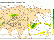
Mean sea level pressure, wind speed at 850 hPa and geopotential 500 hPa, temperature at 850 hPa
One of the drawbacks of these grid forecasts is giving you the weather forecast for an exact grid point. It does not tell you if there is a tropical storm to your south that might be moving towards your location. Also these types of grid forecasts have many other drawbacks but we can discuss that at another time. Bottom line it gives you a very quick snapshot look at the weather.
I like to look at the big picture of upper level weather maps. Surface maps are not the of maps since the major weather peaks are much higher of course. Thus, I look at the 500 mb map which gives conditions at 18,000 foot level. This forecast maps shows ridges of high pressure (usually dry conditions). Contrary to that pattern are troughs of low pressure, (usually precipitation.). One source of these maps is from the Europe (ECMWF) If you see a consistent pattern of the low getting stronger over time in the Bay of Bengal than perhaps a cyclone might be forming
However this takes a lot of studying and understanding the formations cyclones as their movement and formation is similar to the tropical storms in the Atlantic off the US coast which can develop into hurricanes. Once a cyclone forms and has developed and becomes a named cyclone you can go to in order to see exactly where it is. Although once this is named than the storm might be having impacts on Everest in a short period of time. Frankly, it is much better to get an earlier warning from weather professional so you can plan accordingly to stay out of harm’s way.
See if there is a named cyclone
This is just a brief description of what I look at while forecasting for storms. I usually spent up to four hours a day looking at six major numerical forecast models and analyze the major upper level forecast maps, and satellite imagery. Finally getting real time observations from basecamp from my members helps calibrate my forecasts.
Michael Fagin has been forecasting for Mt. Everest since 2003 for expedition groups. For information on his company you can visit his web site www.everestweather.com or email him at michalfagin@comcast.net . You can read my previous interviews with Michael
Thanks Michael, Let’s hope for a calm climbing season!
Climb On!
Alan
Memories are Everything
6 thoughts on “Everest 2014: Predicting Tropical Storms and Massive Snowfalls at Everest”
Thank you Alan, very informative and it’s thanks to people like Michael and their excellent weather reporting which is going some way to preventing disasters on the big hill.
Really interesting post. Michael Fagin is one of the unsung heroes of Everest, and many of us owe our summit success to his skill in weather forecasting every bit as much as the hard work of our superstar Sherpas. Nice for him to have some recognition on your blog, Alan, and to hear his take on Everest’s biggest problem.
Hi Alan, Great respect for your excellent Everest Blog. You might like to know I have got a piece in the Telegraph here in the Uk today about the ever younger age of Everest summiters. http://www.telegraph.co.uk/culture/culturenews/10702538/Mount-Everest-the-chaos-is-growing.html
This is to go with the launch of my new teen/ya book ‘The Everest Files.’
http://www.telegraph.co.uk/culture/books/children_sbookreviews/10702720/The-Everest-Files-by-Matt-Dickinson-review.html
Hope you can put a link on your site maybe?
Kind regards, Matt Dickinson (author of ‘The Other Side of Everest’
Don’t shoot the messenger Nelson 🙂
I have a love-hate relationship with Fagin
Ohh is it ? God Bless this season !
Comments are closed.