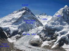
 This past week, there has been extensive media coverage of a “new” route on Everest. Once again, ambulance shallow journalism has misstated reality. The fact is that there is not a totally new route but rather a small change within the Khumbu Icefall that amounts to about 4% of the traditional Southeast Ridge route being effected.
The BBC is mostly responsible for this headline with their article and other outlets picking it up and simply parroting the story. In the first version, since changed, the BBC article, as I read it, suggested the route would no longer traverse through the Icefall at all. While theoretically possible to avoid the Icefall by climbing from Lhotse’s East Face or traversing the flanks of Nuptse, it is practically impossible for the hundreds of climbers, mountains workers drawn to Everest each year.
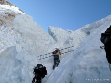
All of the coverage is driven by the tragic deaths of 16 mountain workers on April 20, 2014 from a release of an ice serac off the West Shoulder of Everest into the Khumbu Icefall.
The route is installed and maintained by a team of dedicated Sherpas under the direction of the Sagarmatha Pollution Control Committee (SPCC), Each member pays $600 as part of their permit for this service.
For the last two decades or so, the route went directly underneath the fall line of a serac (the bottom of a hanging glacier) thus increasing the exposure to anyone in the area if the serac released.
The route had migrated towards the West Shoulder from a safer but longer route in the center of the Icefall to accelerate the climb through the Icefall for workers and members alike. Almost every year the serac had released thus the danger was well known, but accepted by most of the workers in order to move faster. Western guide companies, led by Russell Brice, had asked for a safer route for years but their request fell on deaf ears. Brice even canceled his 2012 season based on this danger.

After the 2014 tragedy and with immense pressure from the Nepal Government, operators, world media and climbers, the SPCC re-evaluated the current route and is planning – note future tense – to shift the route away from the West Shoulder and more towards the center for the upcoming 2015 season.
The current estimate is to move the route about 150 feet towards Nuptse and the center of the Icefall from last years position. This may not be far enough if a larger release occurs than last year’s.
The Icefall is approximately 1,500 feet long and the section in danger is maybe 500 feet of that. The total route from Everest Base Camp to the summit is 11,535 feet so we are talking about 4% of the route.
There are few good options for climbing through the Icefall. The center of a glacier moves the fastest and has tall seracs and ice blocks that shift without warning. By moving the route to the climber’s right as seen from EBC, climbers are exposed to avalanches and serac releases from Nuptse. In general, the Icefall is estimated to move 3 feet or 1 meter a day.
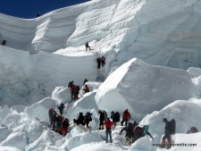
In all cases, the higher one goes in the icefall, the more jumbled and dangerous it becomes. Ladders are commonly used to scale high ice walls.
Pete Athens, 7 time Everest summiter, was interviewed on NPR in an objective, non-sensationalize style. He had recently returned from Everest to work with the SPCC on the proposed route change. Click this link to listen to his interview. He also said:
We had a much colder season this year. We had more snow, and I think that that bodes well, actually, for the icefall. If there’s greater coverage, if there’s greater snow, I think we actually see the icefall route be somewhat more predictable.
From other sources, it appears using helicopters to ferry gear into the Western Cwm has not been approved by the Nepal government for environmental reasons.
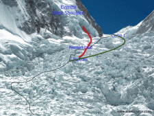
The modified route will make the climb from Everest Base Camp to Camp 1 in the Western Cwm longer by about an hour according to some estimates.
Finally these stories of a “new” route have provided a platform for those wanting to promote climbs from Tibet. The following table is an objective look at the statics from the Himalayan Database comparing the deaths of hired, their term for mountain workers, who went above their respective base camps and died. This covers the time frame from the first deaths in 1922 on the Tibet side to last year’s 19 total worker deaths on the Nepal side.
| Above Base Camp | Deaths | % | |
| North | 3,419 | 23 | 0.7% |
| South | 6,800 | 82 | 1.2% |
| Total | 10,219 | 105 | 1% |
So with all this pre-climb publicity, the world’s attention once again includes Everest. The reality is no one knows where the route will be placed until the Icefall Doctors can evaluate the dangers in person. This should start in late March.
Climb On!
Alan
Memories are Everything
20 thoughts on “The “New” Route on Everest”
Alan, I am aware of Glenn and did google him prior to posting my comment. Not sure the attorney part is relevant to climbing but so be it…….
Glenn, I am happy to send you my climbing resume as well though I would prefer to do so in private message. We have climbed a number of the same mtns. My point: folks who choose not to climb Everest (you) should not be so critical and actually insulting of those of us who choose to do so. That tone from non-Everest climbers is exhausting and has become the norm, particularly after 2014. When one stands at 29,035 (or at least tries), one may then comment. Best to you.
Just leave the mountain in peace…
Why? Do you think the mountain really cares?
Here in California avalanches are averted by” bombing” known problem areas. Not being a climber, just interested – could the government “bomb” the threatened areas, relieving the threat of the avalanche before anyone starts the climb on Everest.
Bob, Everest is considered sacred by the Sherpa people and is in a Nepal National Park thus “bombing” the mountain is not considered an option by the government. Also, the scale and scope of the objective dangers is immense. It would take an amazing amount of arsenal to remove the dangers. Finally, the altitudes are a serious factor in flying in to bomb the seracs.
Thanks, didn’t realize it was a National Park. Now I realize the scale of the idea does seem a little ridiculous.
Not many people understand that Everest is like El Cap in Yosemite to Nepal.
“Bombing” the problem areas ??…..what next !!
Thanks, Alan.
Jim Davidson, I’m sure you must be very interested in how it all pans out for the route. Do you have any preferences? (if you had the choice?)
Wouldn’t going up the west ridge be easier? then cross back to the path above the icefalls
JL, if I understand what you are saying, the traditional entrance onto the West Ridge starts from the Western Cwm thus requiring going through the Khumbu Icefall. There is a lower start to the West Ridge but it begins on the Tibet side. See route 5 in this diagram http://www.explorersweb.com/webtv/videoconsol_everestarial.htm
Another great post, Alan. Adrian Ballinger’s cynical piece of advertorial in the Adventure Journal made my blood boil. Thanks again for providing the facts to keep a check on operators when they step over the line.
Completely agree with you, Mark, regarding Adrian’s advertorial. Totally fine when people want to climb from the north side, but those of us choosing the south side should not be so severely criticized.
Thanks Alan for setting the record straight. Those headlines have been driving me a little crazy, Great writing and thanks for the stats at the end.
Thanks for this fact-based, thoughtful analysis Alan. It will be intersting to see what the icefall route looks like this year.
Comments are closed.