Mt. Massive
Colorado 14er
14,421 feet, 4396 meter
Colorado 14er
14,421 feet, 4396 meter
|
|
Mt. Massive
Colorado 14er 14,421 feet, 4396 meter |
|||||||
|
||||||||
|
Patrick had suggested we take the southeast slopes to the summit and the "tourist" trial back. He had keyed the GPS coordinates into his Garmin and declared we were in good hands. Robert and I nodded politely as he searched for his topo map. We left the camp and walked the road to the true trail head about half a mile away. The early morning clouds were burning away and we felt good about the weather in spite of the 40% chance of afternoon thunderstorms. The trail was well marked and well-worn as we climbed from the 10,000' start. The aspens had a few yellow leaves signaling that Fall was just around the corner. Just as we were making good time on the Colorado Trail, Patrick announced that we need to turn left. I glanced to my left and saw a gentle slope covered with pines. "No trial?" I asked our leader. "Just go up until you break out of treeline", Mr. GPS answered. Trusting my good friend, Robert and I lead the way. Note to self: Why did our leader: never lead from the front?
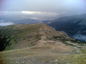
Breaking through the treeline, we were rewarded with a scene only found on the Colorado Rockies. The alpine meadows were fresh with flowers on a backdrop of soft clouds that gave the Arkansas Valley a 3 Dimension look. We gained altitude steadily and followed the ridge towards Point 12,381. The terrain was mostly smooth and the weather was holding but we continued to keep an eye on the sky given the forecast.
Just as fast as the squall hit us, it moved on. Acting like the Chippendales, the shells went off. We conquered the steep face of Point 13,360 albeit with some interesting moves in the scree field below her summit. I continued to look for the escape route as we observed boiling cumulous clouds to the east. About this time we spotted maybe 20 climbers on the normal route heading towards the summit Mt. Massive. We agreed to go to the saddle under South Massive and evaluate the weather knowing that we could escape on the main trial if it turned bad. In reality, that was our only option so the real decision was whether to go for the true summit or not.
The downclimb was uneventful on the main trail and we made it in about 3 hours after taking 5 to reach the summit. This climb was in my top five for Colorado 14ers. The southeast ridge was an exceptional route. The alpine meadows are what I climb 14ers for. The weather toyed with us but allowed us to reach the top and get back down safely. And I felt good. It was good to climb again. Yes, even the GPS was good. But as always, it is who you climb with rather than what you climb that makes a good day.
|
|
 We had arranged to meet at Elbert Creek campground on Friday night but
Denver traffic turned me back so I left at 3:00 AM on Saturday morning
to meet the guys for a 6:30 trailhead departure. I arrived on time to
see them in drenched tents after another night of torrential downpours.
The Colorado Rockies were getting drenched this summer.
We had arranged to meet at Elbert Creek campground on Friday night but
Denver traffic turned me back so I left at 3:00 AM on Saturday morning
to meet the guys for a 6:30 trailhead departure. I arrived on time to
see them in drenched tents after another night of torrential downpours.
The Colorado Rockies were getting drenched this summer. 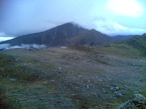 It was incredibly peaceful and a great departure from the well worn
trails of most 14ers to find our way through the trees. Patrick's standard
response to my directional queries was "We're good." So we kept climbing.
At one point to verify our direction I checked the compass on my Sunito
altimeter watch. After 15 minutes of arguing in good spirits, and the
fact that I could never find north!, we all agreed to "trust the GPS"
and climbed higher. Actually all we did was climb straight up though
the trees until we broke treeline. Who needs stink'n GPS's anyway?
It was incredibly peaceful and a great departure from the well worn
trails of most 14ers to find our way through the trees. Patrick's standard
response to my directional queries was "We're good." So we kept climbing.
At one point to verify our direction I checked the compass on my Sunito
altimeter watch. After 15 minutes of arguing in good spirits, and the
fact that I could never find north!, we all agreed to "trust the GPS"
and climbed higher. Actually all we did was climb straight up though
the trees until we broke treeline. Who needs stink'n GPS's anyway?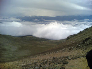 Unsure of which peak was Massive from this route we scanned the nearby
Hills for a Big One. From the Point, Mr. GPS confidently stated we should
"take a straight line" to Point 13,260. The clouds descended. As we started
towards our next waypoint, a snow squall hit us creating a mad scramble
for shells, gloves and hoods. I looked around for the escape route. Colorado
Rockies have taken more than one life due to unexpected storms and a
stubborn determination to reach the summit. This was not going to happen
to us.
Unsure of which peak was Massive from this route we scanned the nearby
Hills for a Big One. From the Point, Mr. GPS confidently stated we should
"take a straight line" to Point 13,260. The clouds descended. As we started
towards our next waypoint, a snow squall hit us creating a mad scramble
for shells, gloves and hoods. I looked around for the escape route. Colorado
Rockies have taken more than one life due to unexpected storms and a
stubborn determination to reach the summit. This was not going to happen
to us.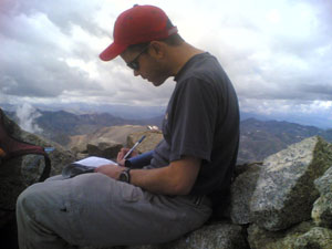 Taking a surprising 8 minutes we stood on the saddle. With six eyes
and years of experience we made the collective decision to go for it.
Robert took the lead to the ridge. We eyed the sky. Perhaps due to my
concern about the weather, I now took the lead and set a fast pace. Within
15 minutes we stood at the base of the summit. The good trail on ridge
enable good time. We regrouped there and took the final steps to the
top together. A snow-white mountain goat grazed nearby adding a sense
of serenity to our summit.
Taking a surprising 8 minutes we stood on the saddle. With six eyes
and years of experience we made the collective decision to go for it.
Robert took the lead to the ridge. We eyed the sky. Perhaps due to my
concern about the weather, I now took the lead and set a fast pace. Within
15 minutes we stood at the base of the summit. The good trail on ridge
enable good time. We regrouped there and took the final steps to the
top together. A snow-white mountain goat grazed nearby adding a sense
of serenity to our summit. 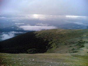 We signed the summit log, enjoyed the view, took pictures, called home
and celebrated our summit.
We signed the summit log, enjoyed the view, took pictures, called home
and celebrated our summit.