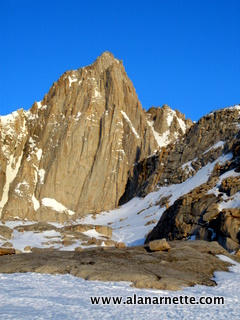
 Mt. Whitney is the highest mountain in the lower 48 US states at 14,491'
(4416m). Of note, it is only 76 miles from the lowest point in North
America, Death Valley at 282' below sea level. Mount Elbert in Colorado
is second highest at 14,440'. And of course, Alaska's Denali is the highest
for the US at 20,320'. Whitney is one of the most climbed peak in North
America given how close it is to Los Angeles and San Francisco with easy
access and a class 1 trail to the top. There are many routes including
world-class rock climbing. As I close in on completing the Colorado 14ers, I set a new goal to
climb all 13 (or 15 depending on your count) of the California 14ers. A
friend had organized a Whitney climb before the lottery period and I
jumped on the opportunity in mid April 2010. The Whitney
Portal Store Message Board served as my primary research and network
tool - a great group of people. After about a month, more than 20 people
had expressed interest in joining in the late spring climb. We became
known as the Board team. There are two common trails to reach the summit of Whitney
- the Mount Whitney Trail and The Mountaineers Route (MR). Both start
at the same place, the Whitney Portal Store. The Whitney Trail is
11 miles long one-way, class 1, and is used by thousands each year. The
MR is about 5 miles topping out at class 3. There is a limit of 100 hikers/60
overnight per day and requires a permit between May 1 and November 1.
Going in April, I still needed a backcountry permit but was not subject
to the quota or the lottery system to obtain a permit. Also, every person
is required to use a wag bag for solid waste - this is included with
your permit. Click on any picture to enlarge it. 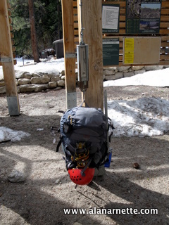 I made the four hour drive from Los Angeles (sea level) to Lone Pine
(3727') enjoying the high desert plains complete with cactus, the airplane
graveyard, and several US Air Force Bases along the way. Lone Pine is
a tiny town full of rich history. It served as home for many old western
movies and today hosts film crews for television commercials and was
the base for filming in the Alabama Hills for
a Star Trek movie. Whitney and the Sierra Nevada Range stand proud
to the West. Whitney was clearly the dominate peak even from 20 miles
away. I made the four hour drive from Los Angeles (sea level) to Lone Pine
(3727') enjoying the high desert plains complete with cactus, the airplane
graveyard, and several US Air Force Bases along the way. Lone Pine is
a tiny town full of rich history. It served as home for many old western
movies and today hosts film crews for television commercials and was
the base for filming in the Alabama Hills for
a Star Trek movie. Whitney and the Sierra Nevada Range stand proud
to the West. Whitney was clearly the dominate peak even from 20 miles
away.
I easily found the Whitney Portal Road in downtown Lone Pine and dropped
into the local gear store to buy stove fuel since you cannot bring it
on an airplane. The Whitney Portal Hostel was nearby as was the common
meeting place, McDonalds. After some fuel and fast food, I headed up
the road to see how far I could go before snow or rock fall closed it
down. It only took a few miles when I saw several barriers blocking the
road. Not wanting to add miles to my hike in, I maneuvered around the
signs and soon was nodding to the front loader driver as he waved me
by. I made it all the way to the overflow parking for the Whitney Portal
store - the trail head for the Whitney Trail - yea! As was to become common, I starting chatting with other climbers and
soon was headed up the trail. However, I paused to weigh my pack on the
community hanging scale - 52 pounds - ugh. Crampons, ice axe, heavy cold
weather gear takes a toll. However, I did not take snowshoes - which
was a good decision in the end. The weather forecast looked absolutely
perfect for the next three days. I wanted to take the Mountaineers Route and had read enough to know
that this is not a trivial climb. One
expert posted on his site:
I cannot say it more clearly than this: The MR in winter is a prime
example of something that only experienced mountaineers, who are skilled
in technical winter mountaineering, should undertake. You need both the
background to know what to do and how to do it, and the breadth and depth
of experience with ice ax, crampons, and snow and ice rope work, to be
able to do it safely. You must have practiced self-arrests repetitively,
and you need to have the maturity, wisdom, and foresight to back off
or change your plan if the conditions or weather dictate. Most often
the situation is not this severe, but you always need to be ready for
it. Climbing the MR in summer will not prepare you, nor will winter hiking
with the occasional use of crampons and ice ax under benign conditions.
To his point at least four people have died in the last several years
on Whitney. The trail at 8,365 feet starts off well marked and well trodden. It
gradually gains elevation through the pine trees and after 3/4 of a mile
the trail splits at the North Fork of Lone Pine Creek into the main Mount
Whitney Trail and the Mountaineer Route. Turning right, the trail
gets a bit steeper but nothing serious. Once again, the trail crosses
the creek and a choice is presented - take the Ebersbacher Ledges or
lower through the willows by the creek. I choose the creek since I was
now alone and didn't feel comfortable navigating the ledges at this point.
Snow cover kept the willows at bay otherwise, the ledges would have been
a much easier option. 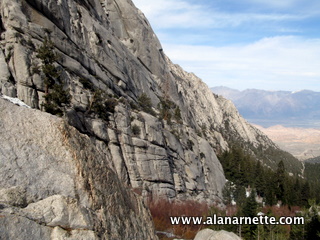 Boot and ski tracks showed the general route up the narrow valley. It
was a steady elevation gain with some small post holing and interesting
creek crossing over questionable snow bridges this warm spring day.
I made good time while inspecting the ledges from below. I was glad I
choose not to navigate them given the confusing nature and need for doubling
back several times. More on this later. I crossed the creek one more
time and arrived at Lower Boy Scout Lake (LBSL) at 10,300' in about
2.5 hours. The closer to Whitney, the more impressive the scenery became. At this point I met Tony and Adam of the Board team. Since it was
around 5:00 PM, I decided to camp and go higher the next morning. The
lake was mostly frozen over but a small area of open water was welcomed.
The night was uneventful and I left for Upper Boy Scout Lake (UBSL) with
Tony at 7:00 AM. We wanted to give Mount Russell a go that day. I should
have left earlier. UBSL sits at 11,300' surrounded by high rock walls on two sides and
the angled hillside to Russell to the East of UBSL. I pitched my tent
and took off for Russell. Tony waited for Adam to arrive. There was no
real trail with the snow cover, just a general direction covered with
varying snow depths. The climb went well but was taking longer than I
had hoped for. Cresting the top of the hill required multiple switchbacks
then French stepping in my crampons on a 50 degree slope at the top.
The view of Whitney was excellent and provided me a preview of tomorrow's
main event. 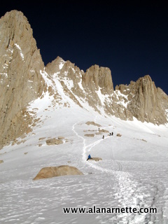 The next section was across a gentle rise towards the Russell/Carillon
saddle. I arrived there around noon and considered my options. Whitney
was my priority for this trip and I knew at this point, I would not be
back down to camp from Russell's summit until late in the day. While
the ridge was clear of snow and and well within my skills, I descended
back to camp given the time frame. Throughout the day, Whitney and the surrounding peaks of Thor and the
Needles peaked into view. It instantly reminded me of the Towers de Paine
in Patagonia. Amazingly rugged and towering, each peak had a singularity
that begged a unique name but more to the point, to be climbed. Back
at camp I ran into a climber who had returned from a Whitney attempt.
He ominously said "Whitney kicked my ass today. I turned back at the
notch because of all the loose snow in the Final 400." I saw a group of 15 climbers snaking up the trail between the Scout
Lakes while climbing towards Russell so I knew the main Board team was
there. They were to camp at Girl Scout Lake, slightly above UBSL. Another
good night at camp, I left UBSL at 6:00 AM to meet up with them. Along
the way, I met Jim and Tom who had something like 100 summits of Whitney
between them. Jim had climbed from parking lot to summit in 3.5 hours
at age 44 a few years earlier! We climbed directly to Iceberg Lake at 12,600' and waited for the rest
of the team. The route was good, marked with tracks. It was not obvious
but you need to stay high on the hillsides and crest to Iceberg lake
without descending into a small valley. This is one of the most impressive
mountain setting I have seen in the US. Whitney dominates the Western
view, and Russell to the North. The couloir, aka the Chute, on Whitney's
right side up was obvious and called out. It was fully snow covered
and looked steep. A few previous tracks remained. 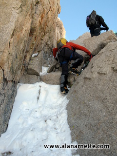 The team slowly gathered at a flat and smooth rock. I was eager to get
going and quickly followed a few climbers who went ahead. At this point,
I got into a steady rhythm of climbing the semi-steep couloir. The angles
were manageable at no greater than 45 degrees. Step by step we moved
higher towards the notch and the infamous Final 400: from 14,100' to
14,500' and the summit. However, the angle and increasing altitude took
its toll on the team as it spread out and a few climbers called it a
day. I arrived at the notch in about 1.5 hours climbing at my normal
1,000' an hour pace. The notch is a fairly flat area that was not snow covered at this point
and served as a good spot for a break. The Final 400 is often spoken
of with some reverence given it is 400 feet of steep climbing with a
short section of class 3 rock that requires a big move. While the actually
climbing is not that difficult the price of a mistake can be fatal. The
Final empties into a 1000'+ drop. If you loose your purchase and cannot
quickly self arrest, trouble is below. I started up the Final clearing the rock obstacle. Some climbers felt
this was the crux of the climb having a bit of difficulty with crampons
on rock. Next was a steep snow climb. A snowstorm only three days earlier
had left about 8 inches of loose snow followed by several warm sunny
days. This was good in that we could kick steps in thus provided a staircase
to the summit. The final 50' feet was the steepest and gave me pause
about the decent. It is important to note that if conditions had been
icy or extremely hard packed snow, this section would have significantly
increased in difficulty. 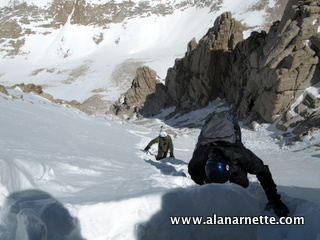 Once on top, it was a bit of a shock to see the large rock hut built
by the Smithsonian Institution in 1909. They used it as an observatory
then. The summit is huge, similar to Longs Peak in Colorado. I made my
way to the Southeast corner and found the geological survey marks and
the summit sign.The views of the snow covered Sierra were breathtaking.
I could easily see Lone Pine and our route far below. It had taken a
bit under two hours to reach the summit from Iceberg Lake. But as they say, the summit is only halfway. The down climb of the Final
400, was perhaps the most difficult part of Whitney's MR. One of the
Board had brought a rope for rappelling and discussions on the board
suggested bring rappelling gear if you were uncomfortable descending
steep snow slopes. The other alternative is to take a class 3 rock climb
down on the east side. This looked straightforward with a few large moves
albeit with the associated risks that fall fall would be problematic
on the steep Final At this point there were about 30 people on the summit from various
parties. I was impressed how everyone worked together, some choosing
to down climb, others to rappel and thus set up the anchors. I choose
to downclimb. The first step feels like you are taking your life into your hands
- or feet. It is maybe an 65 degree slope at this point and even though
we had tracked it up fairly well, we down climbed facing in plunging
our ice axe as far as possible with every single step down. It took
about half an hour to reach the notch. Once there it was free sailing, quite literally, back to Iceberg Lake.
I walked the first section then had a ton of fun glissading the last
600 feet or so. I took a small detour over to the ridge line about UBSL
to call . For some reason, AT&T did not reach the summit but did
1500' lower. A quick chat confirmed my SPOT tracks that all was well. 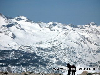 Back at UBSL, I felt great. I was pleased to have made the summit and
new friends. I made dinner and considered my plan to return to Russell
the next day. However, fate prevailed and two things changed my plan.
First, I ran out of fuel and then I accidentally touched my red hot titanium
Snow Peak cook pot when it fell over giving me 2nd degree burns on my
finger tips. Knowing that a climb of Russell's exposed 3rd class ridge
line might require full use of hand holds, I went to bed that night
planning on an easy hike out the next morning.
With my fingers still tingling, I broke camp that morning and caught
up with some of my fellow climbers. We took the Ebersbacher Ledges this
time. While not difficult, I did think the route finding was tad confusing
and appreciated by new friend's directions. The only part that was "interesting" was
a small section of maybe 50' along a narrow crack. Literally, you walk
along a 3 inch crack with a 100' smooth wall below. Interesting with
a 50lb pack on your back. I found Mount Whitney everything it was advertised. The Mountaineers
Route is challenging and satisfying for climbers of almost every level
but clearly requires experience especially for a winter climb. The area
is simply beautiful and awe inspiring. This is what mountains should
look like. I imagine it would be quite different without the snow and
was glad I was there to see the high Sierras covered with the white stuff. It was similar to the more difficult Colorado 14ers like Capital or
Pyramid or even Longs Peak in the winter. However, like all serious climbs
it takes experience, skills and the right partners to minimize the risks.
While I had never met any of the other climbers, I thoroughly enjoyed
climbing with them. They were gracious, friendly and helpful for my first
time to climb in California. If they ever want to do a Colorado 14er,
just call. I highly recommend Whitney no matter what route you take.
It is a solid feeling of satisfaction to stand on the highest in the
Lower 48. Climb On! |