
Mt.
Hood
Oregon
11,237 feet 3,426 meters
Oregon
11,237 feet 3,426 meters
|
|
Mt.
Hood Oregon 11,237 feet 3,426 meters |
|||||||
|
||||||||
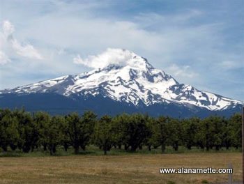 Mt. Hood is one
of several volcanoes on the west coast of the U.S. It is located
fifty miles east of the city of Portland, Oregon in the Mt. Hood
National Forest near the windy town of Hood River. It is very easy
to reach the trailhead since it starts at the parking lot of Timberline
Lodge which is the base for the ski runs located on Hood's southern
slopes. It is common to see skiers high up on Hood. But it can
also be very dangerous as evidenced by the deaths in 2002 of climbers
falling into a crevasse and a helicopter rescue gone bad. Mt. Hood is one
of several volcanoes on the west coast of the U.S. It is located
fifty miles east of the city of Portland, Oregon in the Mt. Hood
National Forest near the windy town of Hood River. It is very easy
to reach the trailhead since it starts at the parking lot of Timberline
Lodge which is the base for the ski runs located on Hood's southern
slopes. It is common to see skiers high up on Hood. But it can
also be very dangerous as evidenced by the deaths in 2002 of climbers
falling into a crevasse and a helicopter rescue gone bad.In final preparation for climbing Mt. Rainier, I summited Hood in July 2004 with two friends, Bryan and Ian. We used the standard route named the Hogsback. It was a long but straightforward day. We climbed independently most of the time but roped up near the summit since the final ridge is quite exposed and it was extremely windy that day. 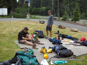 The previous day we visited the Timberline
Lodge to get final information and register with the Park Service.
But all the offices closed at 1:30 PM so we were on our own. We got
the paperwork from a self-service registration stand next to the trailhead
as we left for dinner. At the Mt. Hood Inn we spread all our gear on
the lawn for a final check and a quick refresher course on crevasse
rescue and rope travel. The previous day we visited the Timberline
Lodge to get final information and register with the Park Service.
But all the offices closed at 1:30 PM so we were on our own. We got
the paperwork from a self-service registration stand next to the trailhead
as we left for dinner. At the Mt. Hood Inn we spread all our gear on
the lawn for a final check and a quick refresher course on crevasse
rescue and rope travel.We started at 2:00 AM after a short night at the nearby Inn. The route was clearly marked with a big sign stating "Climber's Route" as well as yellow discs on tall poles. This is designed to take climbers along the east side of the ski runs. The starting elevation is 5,800 feet. The steady slope rises two miles to the top of the ski runs at a 30 degree grade. 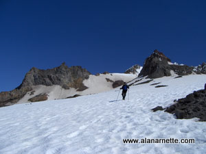 The wind was picking up as we reached 8,600'. I was quite surprised to see only two other people climbing on this day since Hood has a reputation of being crowded. It could have been the winds! As we reached a small plateau at about 9,000' the winds were blowing a steady 30 m.p.h. with gusts to 50 and occasionally to 70. All three of us were knocked off our feet several times. In these conditions going higher seemed foolish and just as I was about suggest turning back, it calmed. Well at least it stopped gusting!  As the sun came up we were treated to the shadow of Hood off to the west. We sighted Crater Rock ahead and to our left and headed up a slightly steeper snow slope. The smell of sulfur filled the air so I knew we were close to the Devils Kitchen, a caldron of steam vents. The ground became mixed with snow and rock as the warmth from the vents kept the snow away in July. 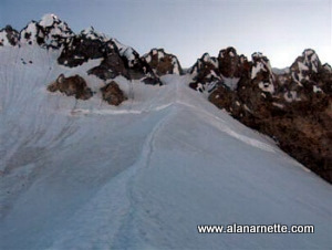 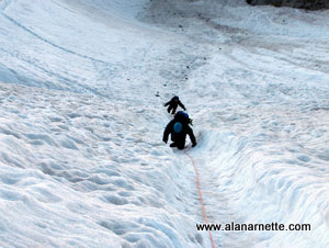 I was a little slower than my friends and given their lack of experience with rope travel (plus I had the rope) and exposure on snow ridges, they waited patiently at the base of the Hogsback (click for video) about 10,600'. Looking at the ridge, it was clear we need to rope up for safety. So on with the harnesses as I pulled the rope out of my pack. I led the relatively short climb up the ridge. A bergshund split the ridge about halfway to the twin rock towers called the Pearly Gates. We took a path to the left to reach a narrow gap in the bergshund. Once across, we continued our climbing to the Gates. Waiting for everyone to arrive, I enjoyed the views of the Kitchen and surrounding pinnacles and ridges. This is an area for rockfall so we left our rope and quickly headed for the summit saddle. About 200' at an aggressive angle and we were there. Once on top, the winds picked up again. It was about 9:00 AM and had taken seven hours to climb the 5400'. We enjoyed the views and took a video and some pictures as well as made a quick climb to the true summit about a hundred feet away and maybe 50' vertical. 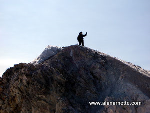 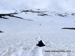 On the downclimb, we roped up
again until we were at the bottom of the Hogsback. From there it was
a simple matter of tracing our steps back to the parking lot. With
the steep slopes, we enjoyed some glissading that sped things up quite
a bit. It took us about 3 hours to return. On the downclimb, we roped up
again until we were at the bottom of the Hogsback. From there it was
a simple matter of tracing our steps back to the parking lot. With
the steep slopes, we enjoyed some glissading that sped things up quite
a bit. It took us about 3 hours to return.Mt. Hood is a little more challenging than advertised, especially if the weather is poor. The route is straightforward as long as you use Crater Rock as your guiding landmark. The crevasses are grouped off the primary route but climbers have been know to "find" them during whiteouts or storms. We thoroughly enjoyed it as a warm-up for Rainier. It was good practice and a summit to boot! It was fun to see Bryan and Ian on their first "alpine" climb using crampons, ice axes, harnesses and traveling roped together. They did great! Ian was far ahead most of the time a testimony to his fitness and Bryan, not far behind Ian, demonstrated his curiosity with his wandering. We had a great time and felt ready for Rainier three days later 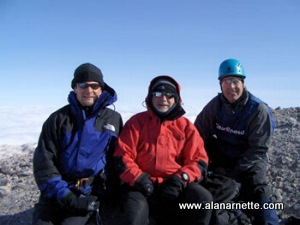 |
|