Memories Are Everything® climbs
raise awareness and research money
for Alzheimer's Disease.
My mom, Ida, passed away from Alzheimer's in 2009.
NO CURE, Always Fatal
No easy and inexpensive method of early detection
6th leading cause of death in the United States
Every 69 seconds another person is newly diagnosed
Impacts more than 5 million people in the United States
and over 25 million worldwide
Burden on families and family caregivers is devastating
both personally and financially
With aging population, these issues are increasing dramatically
And there is hope
100% of your donations go to your selected
non-profit. None to Alan or climbing expenses
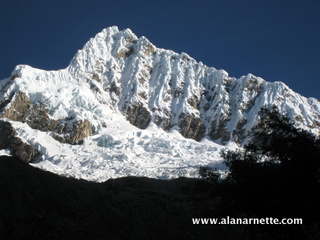
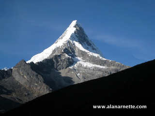
Peru's
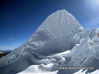
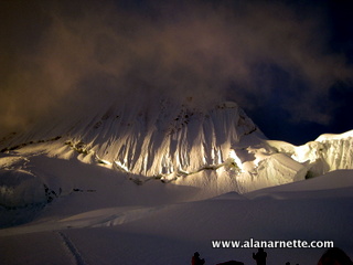
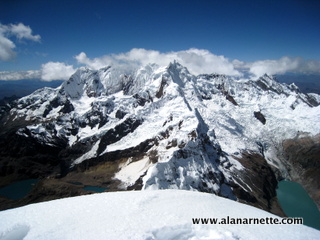
Alpamayo, one of the world's most beautiful peaks, is in the Cordillera
Blanca mountain range of the Peruvian Andes.
I was attracted to this climb due to the beauty of the Cordillera
Blanca, the technical aspect of the summit climb and to do a serious
climb in Peru. The fluted face is reminiscent of the Peruvian peak,
Siula Grande, made famous in the movie Touching
the Void - not a great reference if you have seen the film! :)
click any picture to enlarge
Lima
I
arrived in Lima, Peru after a relatively short 6 hour flight from the
U.S. on June 21, 2012. The plan was to meet up with the small team of
six organized by Phil
Crampton's Altitude Junkies company. I was met at the airport by
the hotel, San Antonio Abad in Miraflores and taken to this simple but
clean hotel outside the main city. I had an extra day in Lima so took
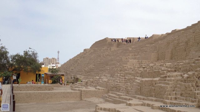
in a few sights including the Huaca
Pucllana, a giant adobe pyramid built around 500 AD. Overall however,
I found Lima a bit dreary, crowded and full of poverty.
Phil had organized transportation to the trailhead with an overnight
stop in the mountain gateway city of Huaraz. The drive up the Peruvian
coastline along the Pan American Highway was interesting for its desolation.
We turned inland after a few hours and soon were navigating extremely
twisting roads that went from sea level to Huaraz at 10,000'. The landscape
was impressive with wide open spaces covered in brown grass against
an ever increasing backdrop of snow capped mountains.
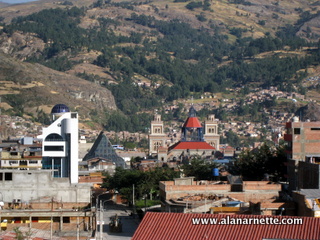
Huaraz
Huaraz, a city of 125,000, had nice parts but overall continued to
show the poverty and the third-world nature of Peru. An earthquake
in 1970 destroyed most of the city and killed half the population at
the time. We stayed at small hotel, Olzas which was arranged by Chris
Benway, an American expat living in Huaraz for over 15 years. The view
from the rooftop deck was outstanding both during breakfast and at
sunset.
Chris runs a logistics service for climbers plus the nicest restaurant
in town, Cafe Andino. He also arranged our transportation, hotels,
base camp cooks, burros and two porters to carry gear to our High Camp,
all for a very low and reasonable price. Phil arranged all the climbing
details including tents, climbing gear and arranged for our team to
have a second leader, Samuli Mansikka, who is the president of the
Finnish Alpine Club.
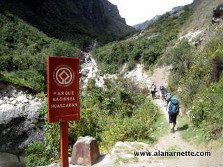
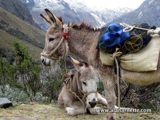
After a relaxing evening at Cafe Andino we took a private van north
towards the tiny country village of Cashapampa. This is where we met
our Arrieros and burros, paid the park fee to enter the Huascarán National
Park. This was the last place we had local cell phone connection via
Claro Wireless.
Trek to Base Camp
The trek was normal for high mountain valleys following a glacial
river along steep mountain walls, cascading waterfalls and ever increasing
altitude at an overall gentle grade other than at the start. I was
surprised to see many people just trekking this valley but should not
have been. We trekked from 9000' in Cashapampa to our first camp at
Llamacorral at 11,500'. It took less than four hours covering about
eight miles. A small shop sold soda and beer there.
The next day we continued following the river passing two turquoise
lakes, Ichicocha and Jatuncocha, before taking a sharp left turn into
a hanging valley to gain over 1,000' reaching the base camp at 14,000'.
This took under five hours and the remaining 10 miles. The burros beat
us there.
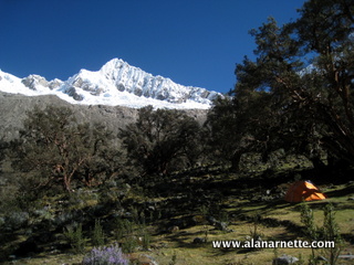
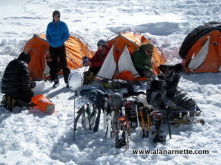
The cooks set up their tent and a dining tent as we set up our Mountain
Hardwear EV3 individual tents. The views were fantastic with the north
east side of Alpamayo just above us providing a clear view of the route
to the Col. To our south was the mountain allegedly used by Paramount
Pictures for their logo, Artesonraju.
Alpamayo Base Camp
We had a great dinner that night before turning in for a carry to
the Moraine Camp the following day. That night, my stomach let me know
something was not right. After a tough night of near vomiting and constant
diarrhea, I took the next day off trying to recover by sleeping the
day away. The rest of the team made a carry of personal and group gear
up the rocky, scree and slab hillside to the Moraine Camp at 16,500'.
It took them about 5 hours round trip.
The next day was a rest day and appreciated by all, especially me.
But Phil, Samuli and our two porters made a carry of tents, food and
fuel to the Col Camp.
The weather was good with clear, cold nights (in the F20s) and warm
days. The night-time sky was excellent with clear views of the Milky
Way and Southern Cross. The only complaint was that there was a lot
of livestock around, from burros to horses to cows thus a lot of animal
waste so you had to be careful where you stepped, or put something
down. Also, the cooks used water from a nearby flowing river but I
was not sure of the overall hygiene. This may have been the cause of
my stomach issues.
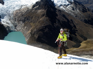
High Camps
Now on day five of the climb, and my stomach feeling much better,
we made the move to the high camps in anticipation of a summit attempt
around July 4th. Since I had missed the carry the previous days, my
pack was a bit heavy around 45 pounds with my climbing gear (harness,
helmet, crampons, carabineers, ice screws, and three ice axes) plus
extra clothes, food and my sat gear. I took my time along with one
of my teammates as we wended our way through the scrub trees, onto
the open hillside then loose scree and finally onto the large slabs
that marked the end of the hill and the beginning of one of the glaciers
coming off Alpamayo. I arrived at camp and promptly vomited. That done,
I felt much better!
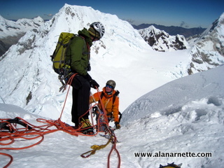
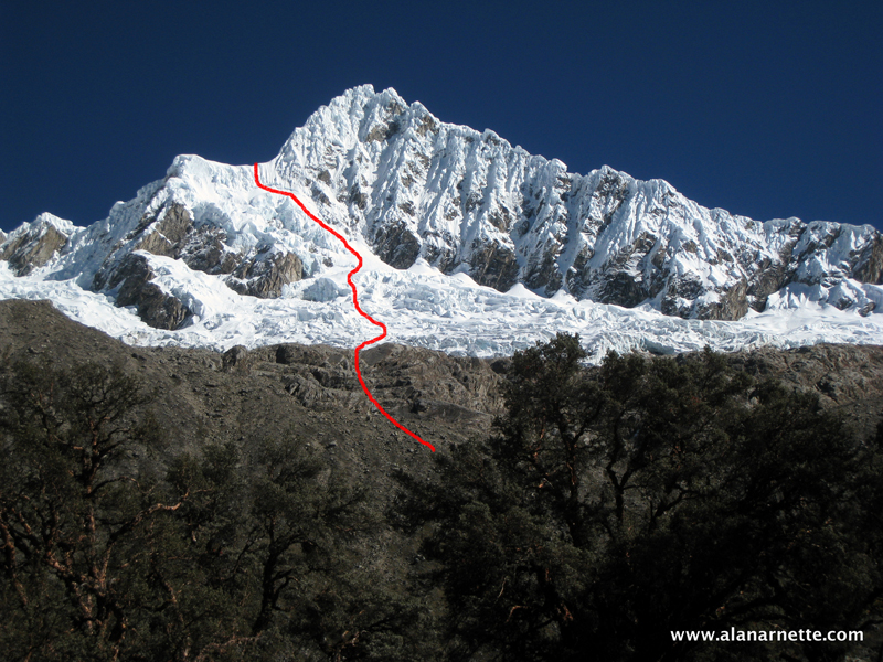
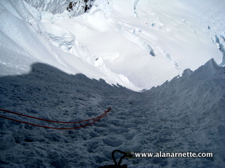
We spent the night and began the serious snow climbing the next day.
We roped up into teams of three and began to traverse the glacier complete
with a few very deep crevasses. Eventually we reached the base of the
final section to the top of the Col. it was about 300' of loose snow
at a 45 degree angle. The last pitch approached 55 degrees. With our
heavy packs this was challenging as we crossed 18,000'.
Once across the Col, we down climbed about 100' to the Col proper
and got our first clear views of Alpamayo to the north and Quitaraju
to the south. I must admit that I was a bit intimidated upon first
view of the Alpamayo Face. It was steep, never ending and unforgiving.
The good news was that there were only a few other climbers on the
Col and they seem to come and go quickly. I had read and heard horror
stories of how crowded it could be so was happy to see we might have
it to ourselves.
Preparing for the Summit
Once again the stomach bug struck but this time it hit everyone else
but me and my tentmate Mclean. Sounds of running to the toilet pit
or vomiting was common throughout the night. We were never sure of
the source as we double boiled our water at the Camp or had re inspected
the cook's processes at base camp.
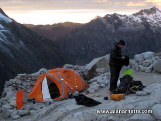
In any event the clouds moved in and the winds picked up encouraging
us to take a rest day at the Col Camp on July 2nd. However half our
team made the decision to return to Base Camp and forgo the entire
climb. Phil took them back down while Samuli, Mclean and I stayed at
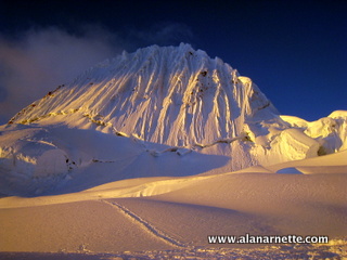
the Col Camp. The sunset and dawn views were incredible but the face
of Alpamayo stood high above all else occupying our thoughts.
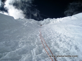
The Summit Push
After a full rest day, everyone was feeling good and we set off to
climb the Southwest face at 7:45 AM. There were two other climbers
already high on the Face but no one else around - perfect. The skies
were perfectly clear, temps in the 20sF and no wind - ideal conditions.
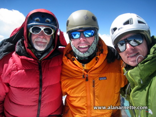
We roped up with Samuli (34) in the lead and Mclean (27) at the end.
I guess they wanted the old man (55) in the middle! There were several
sections to the climb: cross the bergschrund, climb to the summit,
the summit ridge and the descent. We used two 60m ropes.
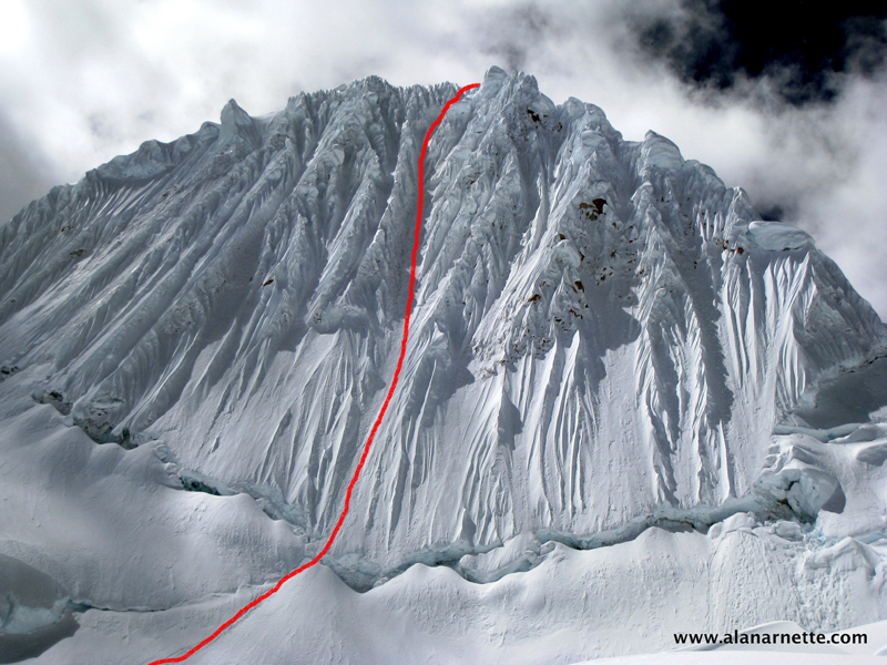
It took about half an hour to reach the long crack across the face,
an ever-present image in all pictures I had even seen. I was surprised
at how fast the angle went from easy to steep. The bergschrund proper
was probably over 60 degrees. I started breathing.
The next section eased a bit to maybe 50 degrees, still very steep,
with loose snow. I carefully placed my two Black Diamond Cobra ice
axes along with my Black Diamond Sabertooth Pro crampons into the Face.
The climb went smoothly at this point.
The middle section turned to hard packed ice with no snow. It took
a few swings at times to get a good tool placement and some serious
kicks to plant the front points. It was physical. The angle now increased
to a sharp 60+ degrees. Samuli placed ice screws with a quickdraw that
we clipped our rope into when there was not a cordlett already attached
to the ice using existing threaded ice anchors (aka, Abalokov threads
or v-threads).
The climbing was serious, sustained and tremendous fun. I was having
a blast!
I took a moment and looked between my legs to see Mclean not far behind
cleaning the route of our pro. He was doing great but I was also struck
by the steepness. If I fell, I had serious doubts the pro would stop
my momentum. I took another kick into the ice and reset my tools.
The final section eased a bit again to maybe 55 degrees before increasing
the final 100' and turned back to soft snow. In spite of what we had
heard, there were no "steps" already kicked into the route
so each move was fresh and clean at over 19,000'.
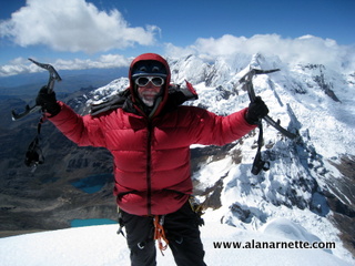
Samuli already on the ridge, belayed me in. As I stepped on the summit
ridge I felt immense satisfaction with what I had just accomplished.
A quick look back down the route and of our tents far below on the
Col gave me perspective. It was very windy on the summit so I put on
my down jacket after climbing in just a shell the entire day.
Mclean soon joined us and I noticed a small boot track to a slightly
high point, the true summit. I walked up only to see one of the most
beautiful sights I have ever seen in the mountains. I smiled and let
out a whoop without regard. For the next half hour we celebrated our
climb, savored the views and took way too many pictures, if that is
even possible.
I took it all in once again reflecting on how fortunate I am to do
these climbs and gave a silent honor to the victims of Alzheimer's;
around the world. I vowed to seal the view into my memory forever.
The Descent
We gathered ourselves and prepared to return to the Col Camp. It took
eight rappels and three hours to reach the Camp. Each rappel required
moving the two 60 meter ropes, tying it into the v-threads or creating
anew anchor. It took a lot of time to do it safely.
We had planned on climbing Quitaraju but the crevasse danger was too
big and no other team had even attempted it this season.
We camped that night at the Col Camp and returned to Base camp the
next morning. We departed for Cashapampa the following day and onto
to Lima for our flights home after a celebration in Huaraz.
Summary
Climbing Alpamayo was a highpoint of my climbing career. It was technical,
challenging and rewarding. It was not a high-altitude "hike".
The expedition was well organized and went very smoothly in spite of
the stomach issues. The Cordillera Blanca area is stunning with it's
mountain beauty. My only regret was that I had not been there earlier
in my climbing career.
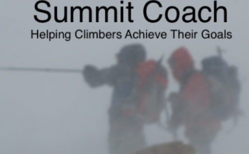
Everest, Denali, Aconcagua? What about K2? Regardless of your mountaineering goals, Summit Coach can help you prepare by selecting the best guides and gear and assisting with mental, physical, and emotional readiness. Alan Arnette has supported hundreds of climbers. Visit the Summit Coach website for affordable pricing and a wide range of customized services.
www.alanarnette.com is provided for informational purposes only and not for advice except through Summit Coach services. Please see the complete
disclaimer