|
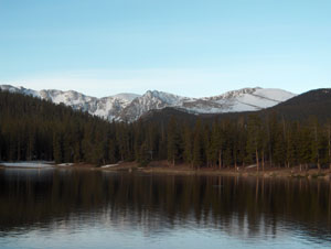 Mt. Evans is the 13th highest
peak in Colorado. It is part of the Front Range and is the closest
14'er to Denver. Evans is the mountain ABC always shows on Monday
Night Football from Mile High Stadium. It is also unique in that
along with Pikes Peak, you can drive to the summit! But that is not
how we did it... Mt. Evans is the 13th highest
peak in Colorado. It is part of the Front Range and is the closest
14'er to Denver. Evans is the mountain ABC always shows on Monday
Night Football from Mile High Stadium. It is also unique in that
along with Pikes Peak, you can drive to the summit! But that is not
how we did it...
The approach is similar to Bierstadt in that you take Interstate
70 from Denver. A huge sign proudly announces Mt. Evans at the Idaho
Springs exit. After a nice 13 mile drive south on Colorado State highway
103 you find Echo Lake picnic grounds and the trailhead for the Chicago
Lakes trail.
There are many trails to the summit and this one is one of
the longer trails. It was 14 miles roundtrip with a total altitude
gain of 5400' but only 3660' as the crow flies from the trailhead at
10,600'. I climbed it in early June 2004 with my friend Robert. It
was 4.5 hours up and 4.5 down for a 9 hour roundtrip for me. This was
one of a series of "easy" 14'ers for my conditioning work as I was
training for a Rainier climb in July.
Many climbers discount Evans since you can drive to the summit.
While this may be true - and it creates an interesting feeling on the
summit, the Chicago Lake route is long with some challenging parts.
It is commonly called the "normal route for mountaineers".
The route starts from Echo lake and passes by the picnic tables
and around the lake. Once into the trees, it drops steadily by about
300 feet before joining a dirt road back uphill for about a mile. Once
past a nice looking trout lake with some private cabins, you finally
enter national forest land.
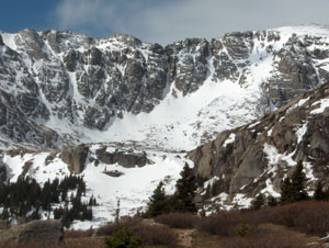
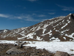
The trail climbs gradually through thick forest, burned out
areas, small meadows and finally passes the Chicago Lakes,
hence the route name. As you near the last lake, a 1300' wall
rises from the valley floor marking the end of the easy trail! If you
don't know where the route is, this can be a daunting moment! By bisecting
the lakes and following the natural slope of the hill, the
route becomes obvious. Some guide books mention carins but we never
saw them.
We began the climb up. It was easier than it looked. The trail
was well worn in many spots and crossed scree, my least favorite surface
on the planet. It took about 45 minutes to reach the ridge with a 5
minute pause to check out a beautiful white goat studying us from a
nearby ridge.
 Once upon the ridge, the let down begun. First we could see
the summit road. Second was a parking lot and third was the 200' decent
before we started back up. Once upon the ridge, the let down begun. First we could see
the summit road. Second was a parking lot and third was the 200' decent
before we started back up.
As Robert and I walked the road towards the summit,
cars passed us. We looked for the trail up without success. It
ended up we did not take the road far enough since we took the
apparent ridge line as our trail and with a careful analysis of
our route (about 10 seconds worth!) we started uphill. The tundra
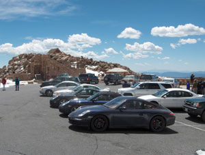
quickly turned into rock and then boulders. We scrambled for a
while and then took a step or two over the ridge to see ... a parking
lot filled with Porsches, SUVs and Harley's ... a first for me
on the summit of a 14'er!
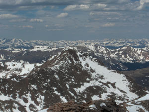
We made our way the final 100' to the summit to find a seat
on the rocks overlooking Denver, the Colorado plains and Longs Peak
far to the north. We also shared our view with all sorts of folks.
Some looked pressed and polished, some casual and some with foo foo
dogs. But everyone was enjoying the spectacular view only found on
the summit of a Colorado 14'er. Click on the summit picture below for
a 360 degree video from
the top.
 We had some
lunch while mumbling "it just ain't right" under our breath" and then
took the normal route off the summit. It was down a very wide ravine
filled with loose rock. We debated if our route up was better than
the route down and agreed that the boulders were better than the scree. We had some
lunch while mumbling "it just ain't right" under our breath" and then
took the normal route off the summit. It was down a very wide ravine
filled with loose rock. We debated if our route up was better than
the route down and agreed that the boulders were better than the scree.
Back to the road and up the ridge. We slid down the "wall" into the
northern most Chicago Lake and began the trek back to the trailhead.
It seemed longer going down than up and we thought about the final
300' up to Echo Lake as we walked.
All in all, Mt. Evans is an easy 14'er. Easy to get to and
easy to climb, depending on the route. The Chicago Lake route is a
Class 2 climb.
I would highly recommend Evans for a winter training climb
or a challenging first 14'er.However, no matter your reason or experience
always take the 10 essentials in your pack
and lot's of food and water.
|