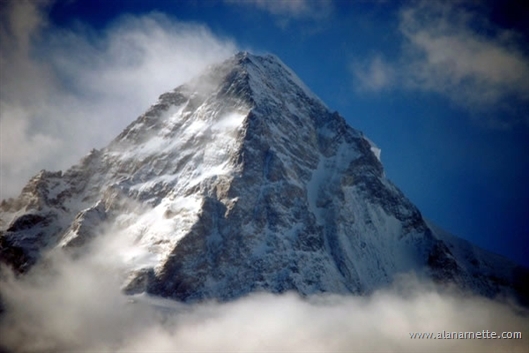
Going to the Karakorum was a spectacular experience. Seeing K2 up close as well
as Broad Peak was unbelievable. I was pleased to have climbed to Camp 2 or approximately
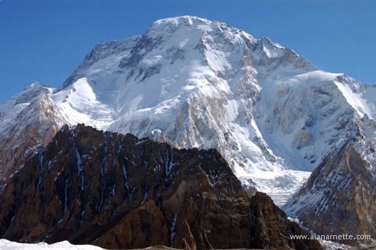
21,000’ on Broad Peak , the 12th highest mountain on the planet. Even though
I caught a horrible bug that stopped my climb, it was a great trip in many respects.
The climb was the result of a year and a half of planning. The plan was
to climb Broad in style and then a limited number of climbers would attempt K2 in
a swift quasi-alpine approach. Few people were planning to use oxygen and the climb
would not be “guided” in the traditional sense but rather have two professional
climbers, JJ and Ryan, who would manage on-mountain activities.
It was conceived in cooperation with Field Touring Alpine (FTA). Everyone paid
them and they ran it under their name. I helped in recruiting climbers from eight
countries, coordinating logistics and interacting with the Pakistani touring company,
Adventure Tours Pakistan (ATP). This was all new to me and I learned a lot about
how expeditions are actually run.
 I
left home on May 31, 2006 for a four leg airplane trip to Islamabad . Arrival at
the Islamabad airport was normal for this part of the world – organized chaos,
stress over whether my bags arrived, x-raying everything and really looking at nothing
and elbowing and arguing with everyone! Upon arrival at the Envoy Hotel, I met many
of our 29 climbers and trekkers for the first time. This was the largest climbing
expedition in Pakistan in 2006. There were five trekkers, eight Broad Peak only climbers,
two K2 only climbers and 15 for the combo of Broad and K2. ATP met us at the airport
and arranged all transportation. I
left home on May 31, 2006 for a four leg airplane trip to Islamabad . Arrival at
the Islamabad airport was normal for this part of the world – organized chaos,
stress over whether my bags arrived, x-raying everything and really looking at nothing
and elbowing and arguing with everyone! Upon arrival at the Envoy Hotel, I met many
of our 29 climbers and trekkers for the first time. This was the largest climbing
expedition in Pakistan in 2006. There were five trekkers, eight Broad Peak only climbers,
two K2 only climbers and 15 for the combo of Broad and K2. ATP met us at the airport
and arranged all transportation.
 The
next part of the journey involved taking two mini busses towards the Northern
Areas and the cities of Skardu and Askolie, about 200 miles to the north. The
first day was on regular paved two lane highways. It was along this section that
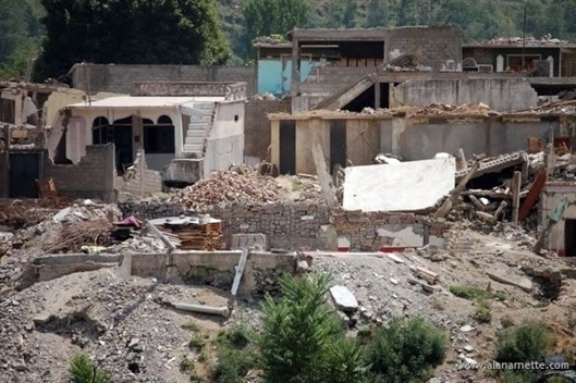
we saw firsthand some of the devastation from the 2005 earthquake. The quake left
over 3 million homeless and killed 100,000. I saw many homes reduced to rubble as
well as entire villages living in UN provided tent cities. One family of ten that
I met had a plastic tarp as their roof while they continued to live in their destroyed
home. The
next part of the journey involved taking two mini busses towards the Northern
Areas and the cities of Skardu and Askolie, about 200 miles to the north. The
first day was on regular paved two lane highways. It was along this section that
we saw firsthand some of the devastation from the 2005 earthquake. The quake left
over 3 million homeless and killed 100,000. I saw many homes reduced to rubble as
well as entire villages living in UN provided tent cities. One family of ten that
I met had a plastic tarp as their roof while they continued to live in their destroyed
home.
After ten hours we stopped at a small hotel in Chilas for the night. The next
day we connected to the famous Karakorum highway (KKH). Built mostly by Pakistani
and Chinese in 1963, about 1000 workers died during the construction. It is the
highest highway in the world. It follows the old silk routes used by Marco Polo and
other famous explorers of their day.
The KKH is sensory overload with hairpin turns, narrow sections, 300’ drop-offs
and drivers who drive so fast that you think they have a death wish! Shortly out
of Chilas, we joined the Indus Highway to Skardu. We stayed at the K2 Hotel in Skardu
which is a medium sized city of maybe 30,000 people and has the northern most airport
in the region. Surrounded by mountains, flights are cancelled on a daily basis since
pilots need a visual reference to land and take-off. Thus our trip to Skardu was
driving, not flying.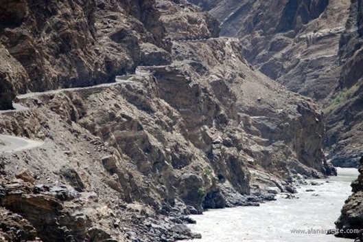
Given
that Skardu is at the “end of the road” – paved anyway,
the next part was in modified Toyota Land Cruisers. Hardened for the rough 4-wheel
drive roads, we left in a fleet of seven jeeps for the five hour drive to Askole – the
true end of the road. The 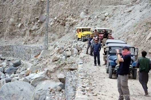 incredibly rough and rocky road with endless potholes meanders
from grasslands to high deserts to deep river valleys. The drivers
seemed to have the most fun when driving as fast as possible! The jeeps, while comfortable,
had no windows so the dust penetrated everything and we were literally shaken to
our bones! incredibly rough and rocky road with endless potholes meanders
from grasslands to high deserts to deep river valleys. The drivers
seemed to have the most fun when driving as fast as possible! The jeeps, while comfortable,
had no windows so the dust penetrated everything and we were literally shaken to
our bones!
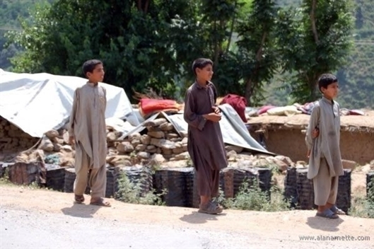
But this was one of the most fun parts for me. As we went through small village
after village, school kids would rush to the side of the road to yell “One
pen please?” It seems they want pens instead of rupees or candy. We noticed
a complete absence of women and were told not to take photographs of them if we
did see any. There were schools but most with signs that read “ Boys School ”.
However as we traveled more north we saw more women in the fields as well as some
schools for girls. Some of the women smiled at us as we passed by.
Meal breaks were at small one room buildings along the way. I suspect they were
relatives of our drivers or operators. It was at some of these stops that people
got food poisoning and where I may have caught my bug. We were all careful not to
eat salads, fruits or drink untreated water. In fact most people drank Pepsi from
sealed bottles.
Finally we made it to the village of Askole . This is where all Karakorum expeditions
to Nanga Parbart, Gasherbrums, Broad, K2 Trango or other climbing spots spend the
night and arrange for porters to haul their gear up the Baltoro Glacier. It is still
60 miles from Askole to the BC for Broad Peak .
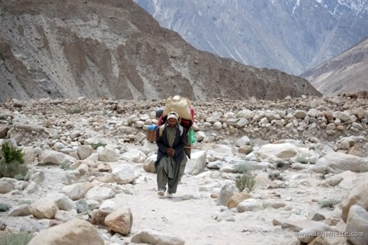
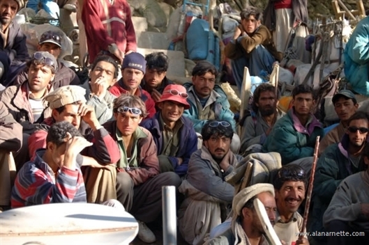 Hundreds of porters live near Askole and compete for the job of carrying 25kg
(55lbs) the 60 miles to the BCs. Askole is at 9,500’ and BP BC is about 15,500’ so
following the rules for acclimatization of no more than 1,000 -1,5000’ a day
gain, it takes about 6 days to reach BC. Porters are paid about US$140 for the round
trip. This is not bad wages considering the per capita income in Pakistan is $600. Hundreds of porters live near Askole and compete for the job of carrying 25kg
(55lbs) the 60 miles to the BCs. Askole is at 9,500’ and BP BC is about 15,500’ so
following the rules for acclimatization of no more than 1,000 -1,5000’ a day
gain, it takes about 6 days to reach BC. Porters are paid about US$140 for the round
trip. This is not bad wages considering the per capita income in Pakistan is $600.
Many porters are required for most expeditions. We hired 250. Remember
all tents, ropes, food, stoves, fuel, personal gear, tables, chairs and everything
else must be carried on someone’s back. ATP really managed all of this and
it was quite civilized. The most interesting part was the weighing of the bags.
Each bag and barrel was weighed with a hand-held scale to make sure it was not more
than 25KG. If it was then the bag was put aside and the owner asked to make it lighter – or
it was left behind!
The ATP cook provided breakfast that was to be repeated daily for the next month:
corn flakes, hot milk, greasy fried egg and sometimes porridge. We left in small
groups for Julah at 10,500’. It took about 6 hours. The Pakistani have an organization
named the Mountain and Glacier
Protection Organization (MGPO) that has
done a nice job of creating formal camp sites for the thousands of trekkers that
visit the Baltoro each year. Each site has solar powered toilets stalls and “clean” running
water. Tent sits are organized but it is muddy and the porters leave trash everywhere
as well as sometimes goat and cow carcasses they killed for dinner. So while it is
a step in the right direction, it is still third-world.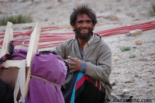
This first day felt long after spending so much time on airplanes, busses and
jeeps with cramped legs. But it was good to be walking and we began to get a hint
of the Baltoro as we progressed. The most “interesting” part of the day
was the very end when we could see the camp across the river but it took another
hour to walk parallel to the camp up the river valley to a wooden bridge that crossed
at the most narrow point only to return back up the valley to the camp. A whole lot
of walking without a lot of progress!
The next morning we left for another 7 hour day to the camp of Paiju. We would
climb to 11,800’. It was a nice day along relatively smooth trails that wend
up and down following the river. The only real obstacle was the hundreds of porters
moving quickly with their loads. It was a good day; however, until a wave of nausea
hit me at our lunch stop that was a sign of things to come.
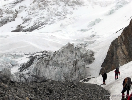
We left the relatively smooth trails of the valley and stepped onto the great
Baltoro Glacier for the first time. The terminal moraine was impressive. Rising about
200’ from
the river, the glacier was in full summer melt and the Shigar River was running fast
and hard. It was one of the most impressive demonstrations of nature I have ever
seen.
The trail now became rough and winding with lots of ups and downs. The Baltoro
Glacier is huge. It is one of the longest glaciers outside the polar region. It is
about 50 miles long. It has everything you expect from a glacier: tall seracs, deep
aqua pools of melting water, fast streams, rocks, boulders and movement. Oh yeah,
lots of ice as well!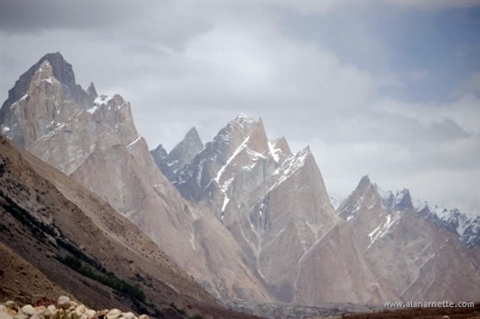
My problems came to full bloom on the Baltoro. As I left Paiju, I felt OK but
knew something was wrong. About an hour out, I took a Cipro. Another hour I began
to vomit. Without going into the details, this continued for the next 8 hours resulting
in me making an emergency camp about two hours short of our destination, the Urdukas
camp at 14,500’.
Thankfully, Carl Drew was lagging the main team due to filming his documentary.
He and two porters came to my aid and generally took care of me. He tried to radio
in vain to the main team for medicine to stop my vomiting. Carl did great and I will
never forget his generosity and kindness. Thank you Carl. Thank you.
I was in bad shape. Carl
told her my resting pulse was 140 and my breathing was shallow. Ryan Waters, one
of our leaders and a trained Wilderness First Responder, literally ran one hour from
Urdukas with the meds. I was close to going into shock. But after the meds, water
and a warm sleeping bag in the tent, I feel asleep with Carl and Ryan watching over
me. Thanks Ryan!
I stayed in my “sick camp” for the entire next day and night considering
if I should return to Paiju or continue to BC. In the end I decided to continue since
I only had 4 Porters with me that did not speak English. There was limited food,
no deep supply of medicine, no access to a doctor and more. Even though it would
have been better to go to a lower altitude, Paiju was not all that clean and I felt
the risks outweighed the benefits.
I made my way through the next MGPO camp of Urdukas and caught up with a few
members of the team at the glacier camp of Ghoro 2. It was good to see them and after
a restful night we continued to Concordia.
Concordia at 15,000’ is just a place on the Baltoro where tents are pitched.
As in most of these camps, there is a Pakistani military camp nearby. Concordia also
serves as ATP’s forward post with a tent warehouse that re-supplies all their
expeditions at K2 , Broad and the Gasherbrums. By the way, ATP is the largest outfitter
in Pakistan and this year was servicing 70 climbs and treks including most of the
major expedition companies you know.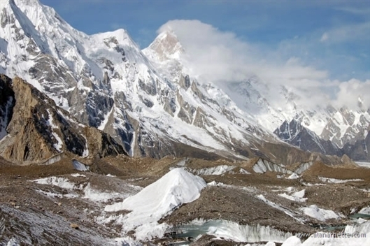
But what Concordia is really famous for are the views. On a clear day, you can
see K2 , Broad Peak and Gasherbrum IV plus hundreds of jagged peaks that line the
Baltoro. The Baltoro
Glacier and
the Godwin Austen Glacier merge here. We stopped for a tea with ATP’s Mohammad
Amien. He has worked at the Concordia camp for many years and dropped name after
name: Messner, Viesturs, Moro and others. Quite a character!
The next day we finally made the trek to Broad Peak base camp – almost
two weeks after leaving home! My heart was softened when I approached the dinning
tent; all the members gave me a sincere round of applause as a welcome and a greeting.
Thanks guys.
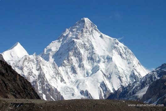 The weather was pristine. Not a cloud in the sky and mild temps with no winds.
K2 and Broad stood large and proud. This would continue for the next few weeks. We
were so lucky since some people trek all the way to Concordia and are greeted with
low clouds, snow and absolutely no views! In 2005, climbers made little progress
on any mountain in the Karakorum due to one of the worst snow years in memory. So
we were quite fortunate in many respects. The weather was pristine. Not a cloud in the sky and mild temps with no winds.
K2 and Broad stood large and proud. This would continue for the next few weeks. We
were so lucky since some people trek all the way to Concordia and are greeted with
low clouds, snow and absolutely no views! In 2005, climbers made little progress
on any mountain in the Karakorum due to one of the worst snow years in memory. So
we were quite fortunate in many respects.
I enjoyed getting settled in my BC tent and finally allowed myself to think of
climbing. I was still weak but felt I had no choice but to get going since at these
altitudes, 15,800’ at BC, you get weaker not stronger. Our cook had a belief
that as climbers we should eat simple, plain food since it digest easier and in his
past seven years as an expedition cook, every team had placed climbers on the summit.
This meant he focused on plain white rice, lentils and steamed veggies – all
without meat or spices night after night after night. Finally a revolt forced him
to make pizza and French fires for lunch but the absence of protein was noticeable
and did not help me regain my strength.
So after a few days, I left for a carry to Camp 1. My pack was loaded with food
for a few days and my high altitude sleeping bag. These would stay at C1 and make
their way to the higher camps as we zigzagged up and down the Hill to acclimatize
to the high altitude.
Broad began to reveal her surprises. The walk to the start of the route took
two hours. It followed a circuitous route along the Godwin Austen Glacier. While
nothing difficult it was easy to get lost. The seracs rose 20 to 50 feet above the
floor. Water ran swift in the afternoons but was frozen in the mornings. Luckily
we had some wands to mark the route but many people still got lost in some case severely
so.
 The start of the climb was at the top of a 200’ scree hill. JJ, Ryan and
three HAPs had gone up a few days earlier and began the thankless tasks of fixing
ropes on Broad. Two other teams, the Austrians and the Australians were on Broad
a few weeks before us but had not fixed any lines. The start of the climb was at the top of a 200’ scree hill. JJ, Ryan and
three HAPs had gone up a few days earlier and began the thankless tasks of fixing
ropes on Broad. Two other teams, the Austrians and the Australians were on Broad
a few weeks before us but had not fixed any lines.
The HAPs proved to be more load carriers than line fixers in the sense that they
actually refused to fix lines, set anchors or have anything to do with the ropes
since they were not paid to do that. But more importantly, they claimed not to have
the knowledge. So left without a real choice, Ryan and JJ set most every anchor from
base to summit on Broad Peak in 2006.
As they established the route Ryan became the first Broad Peak summiteer of 2006.
JJ stopped just below the summit as did the three HAPs not wanting to stand on the
true summit out of respect for the mountain.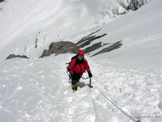
The climb to C1 was good for me. I took my time, clipped into the line for safety
and made my way to 17,500 before caching my load and returning to BC. A few days
later, I returned and made my way to Camp 1 for two nights and on to Camp 2 for another
two nights.
The climb to Camp 1 has two parts: scree to a small flat spot known as ABC at
17,500 and then a steep section to 18,200’. The lower section had growing crevasses
which a few weeks later captured a Spanish climber (he was safely rescued) and the
upper section melted out in the warm temperatures thus exposing hard ice that made
the climbing challenging. 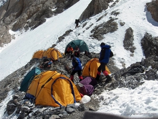
Camp 1 was perched on a narrow ridge with barely enough spots for 5 tents. I
was very impressed with the cooperation of all the teams on the Hill with everyone
sharing their tent, taking unoccupied tents down if the spot was needed and generally
helping each other out. A spot overlooking the route was deemed the latrine. Not
a good spot to say the least!
The route to camp2 actually became steeper. The snow was firm so it was straight
forward but Broad showed us something we had underestimated. Known as an “easy” 8000m
mountain, it is steep. And it does not stop. On other “easy” 8000m mountains
such as Cho Oyu , you climb a steep section but it flattens out for awhile. On Broad
it never flattened out. It just kept going up. Many of us who had been on Everest
noted that it reminded us of the Lhotse Face. There simply was never a break. Even
Camp 2 was on a 30 degree slope.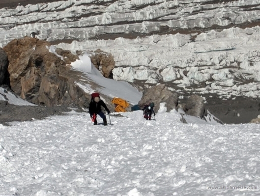
Camp 2 was a great spot. As I said in an audio dispatch, it was so quiet. On
Everest you almost always hear the wind. But here it was calm – at least for
a while. And when it was it was eerily quiet. The only sound was a distance low rumble
of the glacier melt running. No jet contrails in the sky. No clouds. No sound. It
was a moment I will always remember.
I returned to BC from my acclimatization time at the mid camps. Base camp was comfortable
in that the dining tent had warm, sometimes hot, water for drinks. The toilet tent
provided a place to squat in privacy. But more importantly was the time with my teammates.
The dining tent was huge – it held all 29 of us at once. We gathered there
to chat, make plans, compose emails or just to be with someone.
Everyday we did regular radio checks: 9, 12, 3 and 6. “base camp calling
Camp 1” - wait for a response. “base camp calling Camp 2” We checked
on every climber to understand where they were, how they were doing and what their
plan was. Since this was not “guided” each climber had total freedom
to make their own schedule. The only real consideration was tent availability. So
we kept track of who was where and what their next camp was to be to avoid having
too many people at any one camp. Actually it worked out well. With a couple of exceptions,
everyone worked well together and there were no unsolvable conflicts.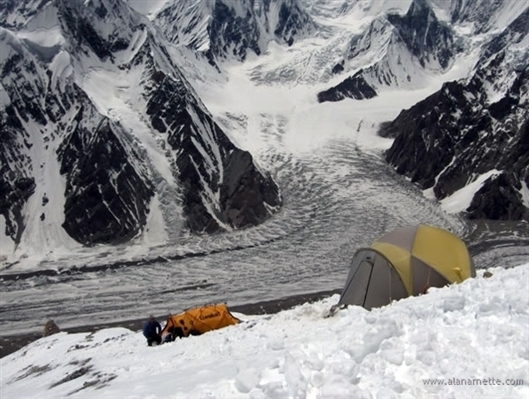
While on this break in BC, I seriously began to question my strength to summit
Broad, much less “make a good showing” on K2 . I was weak and not eating
well. I new I had already lost a lot of weight, including muscle mass – over
22lbs by the time I got home. But I was committed to the climb, the team and my goals.
However, I was more committed to my senior goal – return home safely.
I made the decision to try again. I would pack to go for a summit bid. Go to
Camp 2, spend the night then on to C3, C4 and the summit assuming my body agreed
with this plan. I knew if I did not at least put in a genuine effort one more time
that I would regret it. But at the same time, I drew on my previous experiences to
know the chances were slim. So I had a long conversation with – and myself – to
create a realistic plan.
I left BC along with five other teammates early on June 27 th. We reached the
bottom of the scree in good time enjoying the views of K2 looming in front of us
along the way. We put on our crampons and harnesses and I took the lead up Broad
towards Camp 1. I actually felt great. I moved well, had a lot of strength and confidence.
I soon arrived at the so-called ABC and took off my pack for a rest.
One of the few conflicts then took place when the leader of the Slovakian team
began to accuse us of “cutting their ropes”. They had fixed some line
on an alternate route to this spot and apparently their lines were cut or moved.
The Leader had deduced that our team was the only team on the mountain (which was
incorrect) and was quite vocal and rude in his accusations. We heard him out, stated
the facts and moved on. He would continue this behavior at C1. 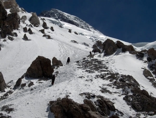
The next section had turned mushy and I began to posthole as I climbed. I sank
up to my knees then my thighs. It was exhausting but I climbed on. After an hour
it became clear that I was weakening. This gave me good fodder for thought as I continued
my climb.
Climbing 8000m mountains require a lot of energy but – more importantly – a
lot of reserves. Using all your energy to reach a camp, or the summit, puts you in
a dangerous position. I knew from my teammates that the summit day was long and potentially
exhausting depending on the snow conditions. I remember speaking with JJ as he Ryan
and the HAPs were on the summit ridge and how tired he sounded. And he is almost
20 years younger than me! I knew that if I was near empty at 20,000’ then pushing
myself another 5,000’ combined with an 18 hour day simply was not smart.
I arrived at Camp 1 fairly well spent. That night I told JJ over the radio that
I was done and wanted to leave the expedition ASAP. It was clear the bug, or something,
had taken all my reserves and I would not recover at these altitudes – even
at BC. He understood and supported my decision. I slept fitfully that night and awoke
to fresh snow at Camp 1. I said goodbye to my teammates at C1. The climb down was
good but sad as I enjoyed my last views of the Godwin Austen Glacier, K2 and the
Karakorum from high-up on Broad. JJ had sent some HAPs to meet me at the scree and
we took the long walk back to BC together.
Two days later I left BC. To my surprise, JJ joined me. He was suffering from
a mean cough and had signs of pneumonia or bronchitis. He had experienced this twice
before on other climbs so he knew the signs and also the cure – get lower fast.
So we set off with five porters hauling our bags for Skardu. We set a face pace since
both of us were motivated to get down and made it back in three days.
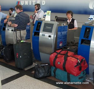
After a shock from Emirates Air refusing to change my ticket back home, I had
to buy new tickets and arranged travel on United and was back home a few days later.
I went to my Doctor the next day and had a battery of test. To my surprise, the chest
X-Ray showed I had bronchitis. The blood tests came back negative so it seemed I
had kicked the bug or left it in Pakistan . Thankfully it appears I had no long-term
damage. That said, I still reamain weak almost two weeks afer returning home
as I write this.
So, how do I summarize all of this?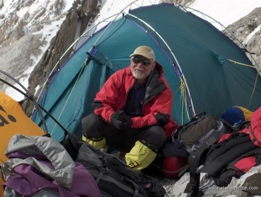
First,
seeing the Karakorum up close was amazing. I have never seen such impressive mountains
anywhere. They have the rugged profile of Towers de Paine in Patagonia , the scale
of Nepal ’s Himalayas and the snowcaps of the Canadian Rockies.
Lining both sides of the Baltoro Glacier it is like a tree lined country road.
 Second the climbing was exhilarating. It was steep, challenging and fun. The
snow conditions were all over the place – mushy at the bottom, reasonable in
the middle, hard and crusty near the top. We were so lucky with the weather. One
long time porter said he had not seen such a good stretch in his 32 years of working
the mountains. Second the climbing was exhilarating. It was steep, challenging and fun. The
snow conditions were all over the place – mushy at the bottom, reasonable in
the middle, hard and crusty near the top. We were so lucky with the weather. One
long time porter said he had not seen such a good stretch in his 32 years of working
the mountains.
Then there was the team. Five trekkers and 23 climbers from eight different countries
all came together with the common love of mountaineering. Most everyone had never
met and the vast majority of the organization and communication occurred via websites
and email. Everyone got along and worked to ensure safety and cooperation. Thanks
team. Well done!
Finally, there was my climb. I am always disappointed when I don’t reach
my goal. This was especially disappointing since it is probably my last 8000m climb.
I love expedition life and being high-up on a mountain. The feel of snow under my
crampons, the wind in my face, blowing snow, clipping into a fixed line, my down
jacket, my down sleeping bag. All are tangible feelings I take away from each climb.
I am pleased that I did not put myself or my teammates in danger with my illness.
I am eternally grateful for the aid I received when I needed it on the glacier.
As it is said; the mountain will always be there.
Climb on!
Alan
|
 I
always wanted to visit the Himalayas in Pakistan. The mountains are legendary: Gasherbrum
I,Gasherbrum II, Nanga Parbat, Broad Peak and, of course, K2. The view from the confluence
of three glaciers at Concordia is live postcard few get to see in person. In the
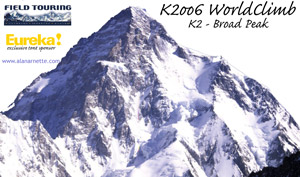
summer of 2006, I attempted Broad Peak (26,401') with the plan to then make a good
effort on K2 (28,250'). This trip report is long but covers all the details. Please
take a look at the pictures and read the dispatches sent during the climb.
I
always wanted to visit the Himalayas in Pakistan. The mountains are legendary: Gasherbrum
I,Gasherbrum II, Nanga Parbat, Broad Peak and, of course, K2. The view from the confluence
of three glaciers at Concordia is live postcard few get to see in person. In the
summer of 2006, I attempted Broad Peak (26,401') with the plan to then make a good
effort on K2 (28,250'). This trip report is long but covers all the details. Please
take a look at the pictures and read the dispatches sent during the climb.