The Nepal Ministry of Tourism has announced another “new rule” for the upcoming Everest 2024 Spring season, after the horrendous 2023 season that set all-time records for deaths on Everest at 18 deaths–6 Sherpas and 12 clients. In my estimation, 11 deaths were preventable. Authorities wanting to reduce bad press made a last-minute rule saying that all climbers must rent a tracking device that would save lives with faster rescues. However, they choose the wrong tool, and the solution to missing climbers requires zero technology, only common sense.
Rakesh Gurung, director of Nepal’s Department of Tourism, told CNN. “Reputed companies were already using them, but now it’s been mandatory for all climbers. It will cut down search and rescue time in the event of an accident.”
A Long History of Tracking Devices
Before we get to technology, remember that the best communication is experience, leadership and preparation. Of the eighteen Everest deaths last year, five were classified as missing. I suggest that these could have been prevented if the member (client) had turned around before they got into trouble or the guide would have turned their customer back when signs of trouble became clear. The best guides never allow clients to be alone anywhere on the mountain. I recall the days when Russell Brice, at Base Camp, would monitor each Sherpa and member- by radio, keeping a written journal of their precise location on the hill throughout the summit push. Russ never lost a climber.
Adventurers (climbers, hikers, hunters, fishers, boaters, skiers) have long known the safety benefits of carrying a device to contact search and rescue if they get in trouble. These devices range from radios, cell and satellite phones to satellite messenger devices like the SPOT and Garmin devices and Personal Locator Beacons (PLBs). But each category has pros and cons and is best matched to the amount of detail you want to transmit, your budget, the terrain, the skills of your teammates, and the availability of local rescue resources.
Let’s start with good old-fashioned handheld radios. Commercial climbing expeditions often use units like the Yaesu VHF/UHF Commercial Grade Dual Band Handheld Transceiver, $144. Another popular radio option for the backcountry is the FRS Band Rocky Talkie Mountain Radio at $110. The only hitch is that there needs to be someone who is always available to monitor your radio frequency. Also, radios depend on line-of-sight but have some capability in rugged terrain. Rocky Talki says their unit will work: Line-of-sight: 35+ miles, Mountains: 1 to 5 miles, Forest/Hills: 0.5 to 3 miles, and City: Up to 1 mile.
Other than radios, most of the devices I’ll cover would not be possible without the GPS developed by the US Department of Defense (DOD) in 1973. It became fully operational in 1995 and currently has thirty-one active satellites. In 2024, consumer devices such as smartphones and watches can have a location coordinate accuracy of up to 4.9 m (16 ft). The European Union, Japan, India, China, Russia, and the UK (Inmarsat) have similar systems.
The first satellite phone call was on July 1, 1962, using the Telstar 1 satellite when Fred Kappel, calling from the Earth Station at Andover, Maine, called then Vice President Lyndon Johnson. However, it took the company Iridium, launched in 1988, to make the satellite phone widely available from any spot on the planet. In 1998, Vice President Al Gore made the first call on that system to Gilbert Grosvenor, the great-grandson of Alexander Graham Bell. The original handset cost $1300, and the service cost $7.00 per minute.
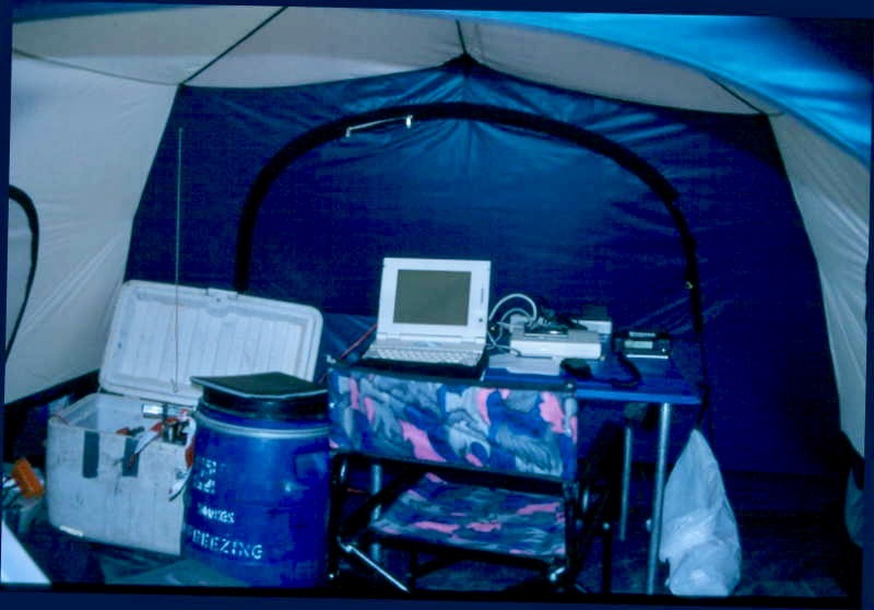
Other companies launched satellite networks, including Thuraya and Globalstar. Thuraya best covers the Middle East and Asia, while Globalstar is best for the Americas, with limited services around the rest of the world. However, it is still expensive to make a call, with most services costing around $2.00 per minute, with reduced costs for higher volume commitments. All satellite-dependent systems require an unobstructed line of sight between the device and the satellite. I used a laptop-style satellite phone in 1998 on Cho Oyu.
Garmin, founded as ProNav in 1989, sold the PS 100, a panel-mounted GPS receiver for the marine market priced at $2,500. Another early product was a handheld GPS receiver used by military personnel in Kuwait and Saudi Arabia during the 1991 Gulf War. More advanced GPS products, including the top-rated eTrex series in 2000, followed this. Today, they sell GPS-enabled wristwatches (Fenix 6), dog trackers, fish finders, avionics, and more.
Garmin’s inReach devices use the globally available Iridium satellite system. The Garmin inReach Mini 2, at $400, fits in your palm and can alert Search and Rescue of an emergency. It can also send and receive text messages—all using satellites, not cell phone service. A subscription is required, starting at $15.00 a month.
The SPOT Personal Tracker popularized the category in 2010. This relatively small device transmits its GPS location regularly using the Globalstar satellite system. One significant benefit was the ability to send a short text message. The SPOT X device costs around $250, with an annual service plan starting at $144. In 2017, the Nepal Government announced they would supply the device to a few climbers as a test, but as usual, it never happened.
Climbers have successfully used GPS devices for many years, but they are not 100% reliable. Batteries run out; users forget to turn them on or drop the device. Sometimes, it will send incorrect coordinates because the signal bounces off the mountain walls. Also, they require a clear sky view, or the signal will not reach the satellite in steep terrain or inclement weather. On my K2 climb in 2014, at one point, my SPOT signal showed I was in Central China, hundreds of miles north of my actual position.
Another less popular option than GPS devices for climbers is a Personal Locator Beacon. Turn it on and push one button to send the device’s precise location to rescue services anywhere on the planet! This is a one-way signal; the device must be on and a button pushed. Thus, it may not be an option for someone alone and seriously injured in a mountain accident. An ACR RESQLINK™ VIEW unit costs about $370, but no subscription is required. I believe this is a valuable backup to any emergency comms plan.
There are avalanche beacons for skiers and anyone worried about getting trapped in an avalanche. This is a two-part system with the person buried wearing a beacon set to transit and the searcher using an identical beacon set to receive. This proven system has saved many skier’s lives. Still, it takes practice and almost immediate reaction since a person’s survival probability plummets from 92% at 15 min to only 30% at 35 min when wholly buried. This is the best solution for backcountry skiers but is used by some mountain climbing teams trained and equipped with beacons.
Avalanche Transceiver: BCA makes a full line of backcountry safety equipment, from shovels and probes to airbag float packs. If you are skiing in the backcountry, out of bounds or in a terrain, this is a must-have piece, plus a shovel and probe. The BCA’s Tracker2 Avalanche Transceiver is well-known for its ease of use and uncomplicated interface. $206
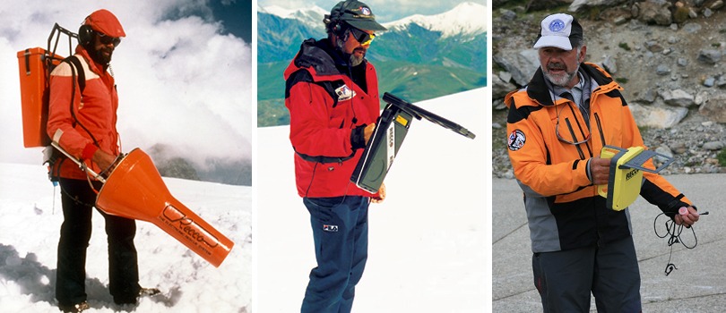
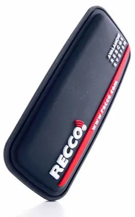
RECCO is a novel solution for finding buried skiers. In 1973, before any electronic aids existed, Sweed Magnus Granhed and his friends were left to search for skiers caught in an avalanche with their ski poles. Motivated to find a better solution, they developed a radar-based solution, the RECCO system.
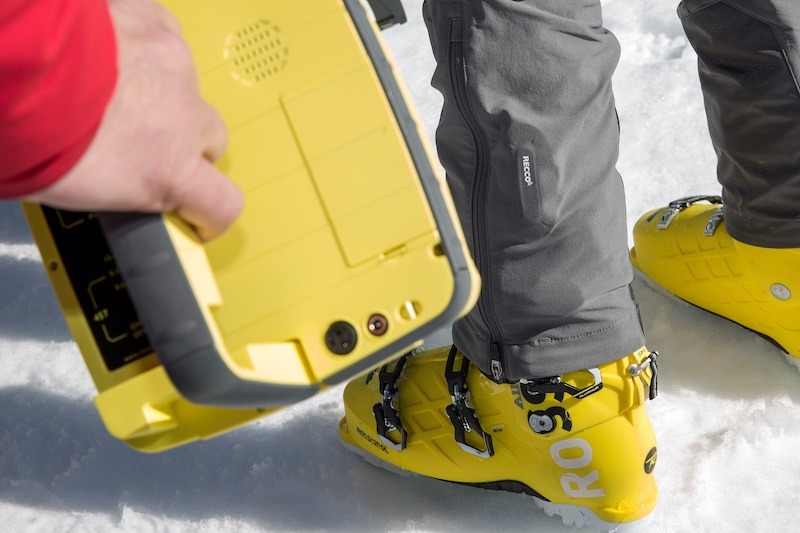
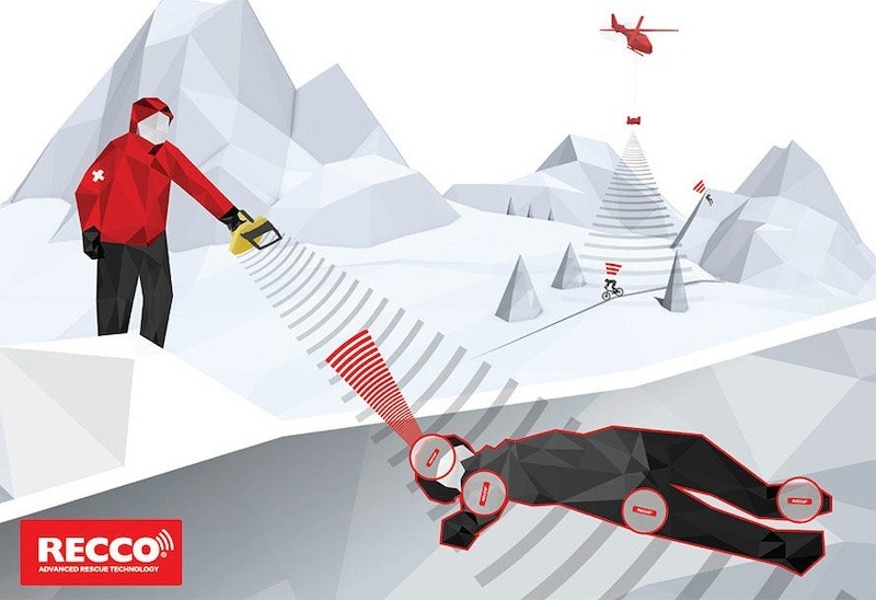
It starts with a small tag (13 mm × 51 mm × 1.5 mm or 0.5 x 2 x 0.05 inches) consisting of two pieces of foil separated by a diode, tuned to respond to a specific radar frequency. The tag is usually sewn into a piece of clothing or attached to gear. A detector transmits a radar wavelength to find a reflector. Radar of a given wavelength is reflected off any piece of metal approximating the correct size and shape, but the RECCO tag has a diode and a second piece of foil that reflect the radar’s energy at twice the original frequency- a relatively easy response for a sensor to detect. The radar can penetrate snow (as in avalanches), but its response is much more robust in hiking or mountain biking, where the tags are above ground. The handheld detector can locate a RECCO reflector up to 262.5 feet (80 meters) through the air and 65.5 feet (20 meters) away through packed snow.
Like an avalanche beacon, it requires a searcher to search for the reflector using a unique detector device weighing 1kg/2.2 pounds. The reflector does not require batteries, activation, or a subscription. It is often sewn into a skier’s clothing, usually their ski bibs, but there are attachable reflectors for helmets and backpacks that sell for $38.00. A RECCO SAR Helicopter Detector allows professional rescuers to perform rapid searches for missing people on a larger scale outdoors. Searching with 100-meter-wide corridors, the RECCO SAR Helicopter Detector can cover about 1km2/0.39 miles within 6 minutes.
With so many options, it’s best to match the right tool to the job.
| METHOD | BEST FOR | PRO | CON | UNIT COST |
| Experienced Climber | Anyone attempting a serious mountain | Self-sufficiency | Time and money to gain experience | Saving your life |
| Qualified Guide | Anyone who’s not a professional | Will keep you alive if properly trained | Cost more. Many unqualified. Some prefer no guide for style reasons. | Money to hire a guide |
| Radio | Wanting limited two-way voice comm | inexpensive, proven | need a good two-way connection. Batteries must be charged | $100-$500 |
| Sat Phone | Wanting two-way voice comm from anywhere | Expensive | It needs line of sight. Charged batteries | $1,000 + $1/minute |
| GPS Tracker (SPOT, inReach, etc.) | Needs two-way text communication | Two-Way Comms | It needs line of sight. Charged batteries | $150 + subscription |
| PLB | You only need emergency comms | Works anywhere, No Subscription | Expensive unit, One-Way comms | $370 |
| Avalanche Transceiver | Snow burial searches | Reliable | Requires two to send and receive, charged batteries, training | $200-$400 |
| Recco | Usually, for snow burial searches | inexpensive | Requires special search detector | $38 |
Nepal 2024 Plan
As I opened this article, Nepal has said they will require climbers (it’s unclear if that includes Sherpas or just foreigners with permits) to rent or buy (I’ve seen both mentioned) a “GPS chip” that will be “sewn into their jacket.” Gurung told CNN that the chips are manufactured in “a European country” but did not specify where or by which company and cost $10-15 apiece for each chip. He said that they would be sewn into the climber’s jacket. Once the climber returns, the chip will be removed, given back to the government, and saved for the next person.”
He told Time, “I want to assure the world that the search and rescue operations and other safety measures will be strictly implemented in Mount Everest, and I would like to welcome more climbers in the season.” He added this about limiting the number of climbers, “the numbers will increase more than last year” because there have been many bookings and requests. When asked whether there would be any limit on permits, Gurung says that if there appears to be any kind of traffic jam in May, “we will think about stopping giving permits.” Of course, no one arrives in the middle of May expecting to summit, so this is a non-starter. Climbers: look for massive crowds in 2024.
So, where do I start with this GPS Chip plan? First, I’m unaware of any device that costs $10 or $15 that can send a GPS signal to a satellite and be sewn into a jacket, so I’m assuming they are talking about the RECCO system. Second, if it is RECCO, it’s neither GPS nor a chip. Other than that, the press reports are correct! But there are more concerns.
Using a RECCO reflector requires the use of the detector, as previously discussed, that weighs 2 pounds and would have to be pre-positioned at multiple spots around the mountain or carried by someone. This assumes the person with the detector would be near a lost or buried person. Searching Everest on foot feels impractical, but it could be done. However, to be successful, it would require multiple people with multiple detectors to search a large area like the Western Cwm or the Icefall. If a person goes missing above the South Col, using this technology feels sketchy. Remember, it was primarily designed for searching ski areas but has been used in other terrains.
Third, if it is RECCO, I guess using the helicopter version of the detector might work, but that suggests sending a chopper to where the missing climber was last seen and scanning the area. This assumes the missing person’s reflector has a clear line of sight to the detector, which is probably unrealistic. The area above the South Col has large boulders and many places where a person could be hidden from sight. Last year, several people went missing around the Balcony, an altitude of 27,300 feet. Most helicopters won’t fly above Camp 3 at 23,000; however, a special helicopter did touchdown on Everest’s summit in 2005.
I will add that if RECCO is used, it could reduce time spent looking for a body, thus reducing some of the risks searchers have.
If Not This, Then What?
If Nepal was serious about improving safety, there are tangible steps they could take:
- Require all climbers to have summited 7000 meters or higher before issuing them Everest permits.
- Require all “guides” to be IFMGA certified or at least have taken climbing, medical and rescue courses at the Khumbu Climbing Center taught by proven, qualified Everest guides
- Require that every person climbing Everest carry a handheld radio
- Each team monitor and write down every climber’s (member and support) precise location when above base camp.
- Establish a central monitoring team at Base Camp and Camp 2 to monitor emergency frequency
- Position trained search and rescue resources at Base Camp, Camp 2 and on a rotating basis at the South Col during summit pushes
- Limit foreign permits to 400 qualified members
- Limit team size to 25 members with 1:1 Sherpa support. BC Staff is additional.
- Ban any operator for one year if they have a client who is “missing” at the end of the season
Do I think any of these will ever happen? NO. There is too much money involved for Ministry Officials and operators to do anything that might reduce revenue and increase costs, even in the name of safety. But Nepal will continue to issue these so-called “safety improvements,” and the mainstream press will continue to help them in their PR campaign with little regard for the truth.
Best of luck to all climbing this season. Stay safe and come home.
Climb On!
Alan
Memories are Everything
The Podcast on alanarnette.com
You can listen to #everest2024 podcasts on Spotify, Apple Podcast, Breaker, Google Podcasts, Pocket Casts, RadioPublic, Anchor, and more. Just search for “alan arnette” on your favorite podcast platform.
Preparing for Everest is more than Training

If you dream of climbing mountains but are unsure how to start or reach your next level, from a Colorado 14er to Rainier, Everest, or even K2, we can help. Summit Coach is a consulting service that helps aspiring climbers throughout the world achieve their goals through a personalized set of consulting services based on Alan Arnette’s 30 years of high-altitude mountain experience and 30 years as a business executive. Please see our prices and services on the Summit Coach website.
Your analysis is flawed for one reason. No where in the CNN article does it say the chip cost $10-15 each as your claiming.
The CNN article says ” He explains that climbers will pay $10-15 apiece for the chips, which will be sewn into their jackets. Once the climber returns, the chip will be removed, given back to the government, and saved for the next person. ”
So the $10-15 dollar is rental price, not a per unit price.
Some GPS dog tracking devices would possibly function up there if there was a working cell coverage. Base camp might have it, but how about the upper mountain? Tractive has a device with long enough battery life to summit Everest and get back down. Cost at wholesale prices might be around $40, not $15. Which still is relatively cheap. Some smartwatches might already have the same capabilities but the battery life is a problem up there.
That said it seems that people suggesting these in Nepal do not understand the technology and/or the realities at the mountain (recharging, actually using the devices). Just invent something which sounds comforting, and lines someone’s pockets as suspected.
All good points, Petrus. Cell coverage good at EBC, but is spotty at best, especially on the upper mountain. Short of giving everyone an InReach, which will never happen due to costs, an old-fashion walk talkie would work if someone at base camp tracked them. However, you’re right that the technology like used in dog fences could be an option, but it would take miniaturization, long battery life , as in a week or more, and rugged design. We’ll see.
Great summary Alan, thankyou. I agree with your general conclusion, in that the best solution is to stop rescues being needed in the first place (or minimise them), through better leadership, experience and self sufficiency on the mountain. Giving the assurance of rescues will just encourage more inexperienced climbers to turn up. Didn’t Denali have a similar problem in the 1970s and 80s? Jon Waterman’s excellent book, Surviving Denali, covers this point well. The fact that these policies are being led by the Department of Tourism tells us all we need to know.
Yet another in a long series of non-sensical and wholly ineffective “solutions” coming out of the government in Nepal. It would be comical if it wasn’t so serious. Will do absolutely nothing except add ridiculous logistics and probably line someone’s pocket.