After a few years of work, and suspense, China and Nepal jointly announced that they have an updated measurement for Mt. Everest, and both countries agree on it. The 2015 7.8 magnitude Gorka earthquake is believed to have impacted the mountain’s height, now we know … at least as far as these measurements go.
China had claimed the height to be 8,844.43 meters /29,017.16-feet underneath the snow. Nepal has claimed 8848-meters/29,028-feet using the top of the snow. And using the best GPS technology available, the US National Geographic Society from the United States measured the height of the mountain as 8,850 meters/29,035 feet in 1999.
Drum roll: The new measurement is 8848.86 -meter/ 29,031.69291-feet, a 0.86-meters or 33.85827 inches higher!
So does this make a difference? Not in my mind. The only interesting point around this is that this measurement is from the rock, not the top of any accumulated snow. Also, it just makes the original measurement even more impressive. The Chinese used state of the art technology, while The Trigonometric Survey used basic math and raw human skills, and their measurement was a scant 9.06 meters different – amazing!
As I show in the table below, Everest’s height has ranged from 8839.8 to 8848, so the press is cherry-picking whatever height they want to sensationalize this news but both China and Nepal had agreed on 8848, so for me, that was their benchmark.
As a climber, this is not material to me because, you don’t stand on the rock on the summit but rather on the snow, and that varies year to year. So while interesting, it’s rather academic but glad to see the two countries cooperating!
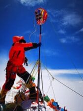 China closed all of its mountains to foreigners on March 11, 2020, but made an exception for Chinese and Tibetans who eventually put 51 people on the summit. However, the larger goal was to measure the height of Everest using the latest technology. A 53-person survey team did the job. Nepal, also wanting to measure Everest performed their survey from 2017 to 2019 with a team starting for the lowlands of Nepal, eventually taking measurements from the summit. Both countries have spent months making tedious calculations.
The 2020 Chinese survey team had several goals according to this source:
- First, rely on Beidou satellite navigation system to carry out survey work;
- The second is that the domestic surveying and mapping instruments and equipment comprehensively fulfill this measurement task;
- The third is to apply aviation gravity technology to improve measurement accuracy;
- The fourth is to use real three-dimensional technology to visually display the natural resources of Mount Everest;
- Fifth, the surveying and mapping team climbed to the top to obtain reliable measurement data.
Peak 15, aka Mt. Everest, has been measured multiple times:
- 1802-1852 – Great Trigonometric Survey: 29,002-feet/8,839.8-meters or 8840m
- 1849/50 – Remeasurement using optical techniques: 29,141-feet/8882-meters
- 1955 – Survey of India Service: 29,029-feet/8,848-meters (snow cap)
- 1975 – Chinese measurement of 29,029.30-feet/8848.13-meters (snow cap)
- 1999 – American Everest Expedition (Bradford Washburn): 29,035-feet/8850-meters (rock head; snow/ice elevation 3-feet/1-m higher)
- 2005 – Chinese Academy of Sciences: 29,017.16-feet/8,844.43 meters (rock head)
- 2010 – Nepal and China agreed on 29,029-feet/8,848 (snow cap with rock head at 29015.9-feet/8,844-meters)
- 2015 – Gorkha Earthquake is thought to have reduced the elevation by 1-inch/2.54 centimeter
- 2019 – Nepal remeasures, including reaching the summit: 8848.86 -meter/ 29,031.69291-feet
- 2020 – China survey team is completed taking measurements: 8848.86 -meter/ 29,031.69291-feet
Scientists estimate Everest increases in elevation between 0.5-inch to 3-inches/1.27-cm – 7.6-cm each year. This growth comes from the Indian continental plate tunneling underneath Asia’s.
Climb On!
Alan
Memories are Everything
Great analysis, Alan!
From the climbing perspective, is it possible that the Hillary step would pose a challenge again in the near future given the fact that Everest is growing @ 0.5-inch to 3-inches/ year?
Hello Alan
Having likely missed this somewhere along the way, please forgive me if I am repeating a prior discussion.
My question is whether the configuration of Everest’s “The Step” was determined to be altered as a result of the earthquake? And if so, how and its impact upon the climb’s difficulty. Knowing the answer may be subjective, I would value your thoughts on the matter.
Thank you, in advance, for your answer. And, hoping you and your family are all healthy and happy.
Respectfully
Carolyn L
(Less than 20 miles south of your old hometown.)
Hi Carolyn, Yes, the Hillary Step has definitely changed and is no longer the obstacle it once was. That said, it still presents a challenge for some people. I covered it in this post, along with some before and after pictures. https://www.alanarnette.com/blog/2018/05/15/everest-2018-hillary-step-or-slope/
Being a geologist and a numbers guy at heart, I have a lot of questions… but the biggest question in my mind is: Now that it is two feet “taller”, do we all have to go back and climb it AGAIN?
Yes, but you have to remove the snow and touch rock.