
 Sometimes it is the little thing. I have climbed on Longs Peak perhaps 70 times in all kinds of weather by multiple routes. But one small goal has eluded me for years.
You see, way back in the early days of Rocky Mountain National Park, an enterprising ranger named John Clark decided to help out his fellow climbers by painting an arrow directing climbers to the saddle between Longs Peak and Mt Meeker. The area is a rock filled gully and can be very confusing so some type of semi-permanent sign would have been useful. Of course today that would be illegal and considered graffiti!
Anyway, On June 30th, 2010, I set out to find Mr Clark’s work of art. I have been on this route several times and knew the general location but somehow I could never find it.
Climbing solo, I set out from the Longs Peak trailhead just off Colorado Highway 7 about 6 AM. It was a perfect day in the Colorado Rocky Mountains with mild temps and clear skies. However, it was the time of year for afternoon thunderstorms so I knew I had to keep a steady pace and be off the summit by noon.
I climbed through the quiet pine forest along Alpine Brook and reached treeline as the sun was lighting up the Colorado plains to the east.
Soon I was at the sign post to Chasm Lake or to Granite Pass, the two primary approaches to climb Longs. I took the left fork towards Chasm Lake and the Loft Couloir, a 1000′ climb of mixed rock, scree and snow.
Even though I had my double plastic boots and crampons in my pack, I avoided the snow in the couloir and stayed with my lighter hiking boots. The route near the top of the Loft Couloir is kind of confusing. You have to find an exit ramp that is nestled in the rock wall. I found it and made my way to the Loft proper.
The Loft is a vast expanse of rock rubble serving as the saddle between Meeker (13,911′) and Longs (14,256′). The trick upon arriving at the Loft is to find the correct down climb towards Longs. I have always found the same chimney and did again this time but have never been convinced it was the correct one. My choice requires a few large climbing moves with 300′ exposure. If I fell, it would mean serious injury or worse; that is the definition of class four or even low five.
The route descriptions usually talk about exposure no higher than class 3 thus my belief I had chosen poorly. However, I am confident in my skills at this level and quickly down climbed the chimney.
Once down below the Loft, I began my search. Again, I knew the Arrow marked the route up to the Loft and was designed to be seen by climbers returning from the summit of Longs. It must be somewhere close. As I turned north towards Keplinger’s Couloir, I looked about carefully for the Arrow.
This is a magical place with high rock walls to the east and a steep slope of hard rock falling to the valley floor to the west. And of course the snow covered Rocky Mountains provide a dramatic backdrop. Not many people take this route so even on crowded summer weekends, you can find the serenity of the mountains here.
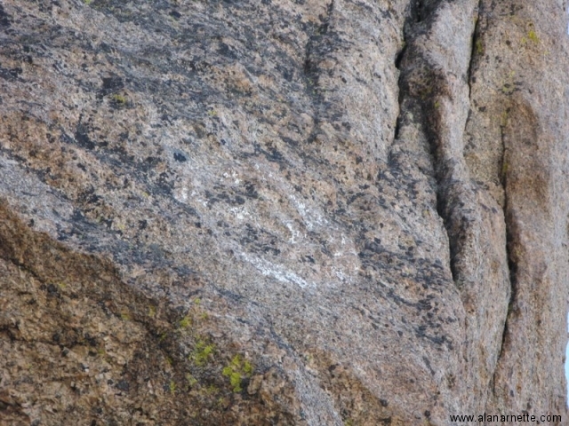
As I was admiring the view, I said out loud to no-one “There it is!” and I had found Clark’s Arrow. To keep this in perspective, many people do find it but many do not. I was pleased to be on the find side of the ledger.
I was a bit surprised at how faded it was in spite of knowing this beforehand. I thought it should had been bigger, brighter, more dramatic. But then again it was decades old and totally exposed to all Mother Nature could hurl.
I noted an adjacent chimney or small gully next to the Arrow and thought that it may be the one I should take next time – and will. However, speaking with a Ranger a few hours later, he confirmed that there was no ‘easy’ down climb from the Loft and the one I chose was as good (or bad) as the others. For aspiring cartographers, the GPS coordinates are 40.251326,-105.613916 about 13,166′.
I took a few pictures and a video. As l continued my climb to Long’s summit, I could not help but to turn around several times to admire the Arrow and think of all those early climbers who depended on this little mark to show them the way home. I wonder if anyone paid a price for missing it?
Once on the summit of Longs, I enjoyed a few moments of total solitude on one of Colorado’s most popular 14ers. But with the clouds boiling I quickly descended via the Keyhole route and took several pictures to document the conditions for the site 14ers.com. This time of year, there are almost daily questions about the conditions of these routes so a few pictures would be helpful.
As I drove home, I enjoyed the satisfaction of finding Mr Clark’s work and thinking about those early days. Here’s to you Mr. Clark.
Climb On!
Alan
[nggallery id=5]
3 thoughts on “Finding Clark's Arrow on Longs Peak”
Cool! Did you waypoint it with a GPS?
Thanks Paul, yes I found Clark`s Arrow at 40.251326,-105.613916 about 13,166′
Great trip report! Always cool to find the little hidden things people may not know about. One of these days I need to make my way out there for some hikes. Those mountains look splendid!
Comments are closed.