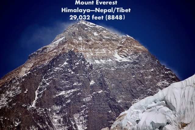
Everest Background Climbing Information
Everest Home | Pictures | Climbs | Coverage | Statistics | Essays | Extras | F.A.Q. | Links
I summited Everest on May 21, 2011 and have climbed it three other times (all from Nepal) – 2002, 2003 and 2008, each time reaching just below the Balcony around 27,500′ (8,400 meters) before health, weather, or my own judgment caused me to turn back. I attempted Lhotse twice – 2015 and 2016. When not climbing, I cover the Everest season from my home in Colorado as I did for the 2004, 2005, 2006, 2007, 2009, 2010, 2012, 2013, 2014, 2015, 2016, 2017, 2018, 2019, a virtual 2020 season, 2021, 2022, 2023, 2024, 2025, 2026 and soon the 2027 season.
Follow Alan Arnette’s Annual Everest Coverage
“One of the world’s most respected chroniclers of Everest” — Outside Magazine
Read the Latest Season Coverage
Read the Latest Everest Statistics—summits, deaths, by sides, climbers
Sign up for post’s notification
This page is covers a wide rage of Everest background climbing information
Dressing for Everest
What do you wear when the temperature goes from 100° F to 10° F in a matter of minutes? Oh, and you have to carry everything in your backpack. Oh, and the wind may go from calm to gale force. Ok, let’s not forget a blinding whiteout. Exaggeration, Hyperbole? No, it is the Western Cwm on Everest’s South Col route.
Clothing is one of the most important investments high-altitude climbers make. It literally becomes a matter of life and death during the climb. The short answer to the dilemma is layers. In other words, a well-thought-out system of varying weight layers of clothing that are easily removed or added as the conditions change.
There are three basic levels: wick, warmth, and wind/snow. Let’s take them one at a time.
Base Layer
Removing the moisture from your skin is the key to maintaining a warm, comfortable, and safe climbing environment within your clothing. There are several ways to manage this moisture. Most climbers wear very lightweight capilene or my strong preference, merino wool, next to the skin. This layer wicks the moisture away from the skin and, hopefully, evaporates.
The other advantage of this layer is that it dries quickly. You always hear never to wear cotton while climbing; this is because it does not wick nor dry. A layer of wet clothing against your skin can accelerate hypothermia, frostbite, and even death. Many climbers have suffered this fate; thus, the importance of the base layer.
Warmth Layer
The next layer is for warmth. There are many choices here depending on personal preference and/or conditions. I like a medium-weight pullover top or a full-body suit that is made of a medium-weight fleece that breathes, thus allowing moisture wicked away from the skin to pass through. Many climbers use fleece jackets and pants.
Snow/Rain Layer
The final layer is for protection against wind and snow. The standard for high altitude is down. There are two approaches—a full down suit or separate down jacket and pants. The full suit has the advantage of no gaps at the waistline. This is important when you are bending over to clip in or reaching for difficult holds. In high winds, this gap can “leak” and destroy your carefully designed cocoon. You can also sleep in a full suit and bring a lighter sleeping bag to the High Camps. The disadvantage is that when it warms up, you cannot easily strip down. The standard procedure is to pull the top down and wrap the arms around your waist. This is very bulky and is still hot.
A separate down jacket has the advantage that it can be used in camps, during rest stops, and during the climb. Pants have the same advantage. Down is the warmest insulating material but becomes useless when extremely wet. Primaloft or synthetic down avoids this problem but is not as warm. Most climbers select down for their critical layer at high altitudes.
Some climbers incorporate a Gore-Tex jacket and/or bibs as an outer layer in strong wind conditions where it is not extremely cold.
Head and Hands
Finally, protection for the hands, head, and feet completes the system. Again, layers apply here as well. I cover boots below, but the summary is wool socks, double insulating boots, and integrated gaiters to keep the snow out.
Hands are protected with lightweight “liner” gloves followed by a wind stopper type material on a heavier glove. And for the highest altitudes, down mittens—not gloves—that create an inner air space to keep fingers warm.
The head is usually protected with a knit skull cap made of windstopper material. As conditions get worse, a full balaclava that covers the nose is used. A neck warmer is a must. Finally, the down hood from the suit or jacket completes the cover. Glacier sunglasses that block 99% of the harmful light are a must, sometimes combined or replaced by goggles in windy and blowing snow conditions.
As you can see, there are many levels, pieces, and approaches that go into the climbing cocoon. It is expensive to get all this gear and also takes some time to get used to wearing the right layer for the conditions. The goal is always not to be too hot or too cold.
See my gear list from a few years ago. Summit Coach Clients receive the latest recommendation.
Training For Everest
How do you train your body to withstand a third of the oxygen in every breath, every muscle screaming for more blood while your insides literally are dying while you sleep? Perhaps an even better question, other than why, is how do you train your mind?
Veteran Everest climbers know what they will experience. First-time climbers are shocked at the experience. My personal experience was difficult. I experienced a lung infection that stopped a climb, and on another, my body simply refused to acclimatize above 23,000’. With the clear disclaimer that I am not a doctor and everyone should visit their own Doc before entering any kind of Everest training program, let’s talk from experience. Also, there are many programs out there, so this is just what I like for myself. So what is the best way to train your mind and body to make the top … and return, safely?
There are many approaches to athletic training, all the way from the nightly jogger to the weekend warrior to dedicated amateur to the professional. Often it boils down to time and motivation. The vast majority of Everest climbers have full-time jobs, full-time families, and cannot spend several hours a day for a year to get in professional shape.
The professional or highly dedicated will speak of VO2 max, which is the maximum rate your body can move and use oxygen during periods of high stress or need. Another couple of terms are anaerobic threshold (AT) and lactate threshold, which is when the chemical lactic acid begins to build in your bloodstream and muscles, thus preventing the body from functioning at full capacity. A qualified doctor or trainer can measure these levels through a series of treadmill and blood tests.
However, the essence of these measures and tests is to determine how to get red blood cells to your muscles, and that is the key to climbing Everest. There is a third of the available oxygen on the summit of Everest, thus making your heart, lungs, and muscles cry out for more oxygen during the climb. Red blood cells, which carry oxygen-rich blood to muscles, are increased in response to this lack of oxygen. However, this takes time; thus, the acclimatization process where you “climb high, sleep low” to encourage the production of these red friends.
Training before you get to Everest must begin 12 to 18 months with a focused, intense, and balanced exercise program – after a checkup from your Doc. In my mind, there are three major phases: foundation, aerobic/strength, and peaking. The major groups to work on include: heart, lungs, abs, lower back muscles, thighs, and calves.
The Price of Your Toes
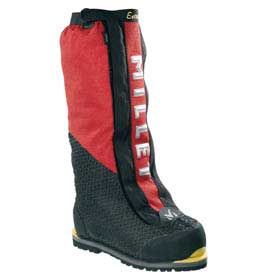
Proper footwear is one of the most important choices when climbing Everest. And it is fairly simple. But it is also bewildering. Not only must you choose the style but also the socks, warmth, and the unknown.
The most common boots used on Everest today are models that incorporate an insulating inner boot and a hard outer boot. The most popular boots are the Olympus Mons Evo by La Sportiva, Millet’s Everest GTX and Scarpa’s Phantom 8000. These boots also have an integrated gaiter, thus simplifying getting dressed in the morning and providing a closed environment for your foot. I used the La Sportiva, Millet, and Kayland models for many climbs and never, ever got cold or wet feet.
Another option used by some climbers is a warm climbing boot such as La Sportiva’s G2 Evo. It also has an inner boot that fits snugly inside the outer boot. Some climbers use an outer boot for maximum warmth in extreme temperatures. I also have used similar boots on Denali and Aconcagua with no problems and with and without the outer boot.
The key to all these models is the inner boot. It is an insulating polyethylene barrier plus an aluminium layer to reflect heat produced by feet. Some climbers are starting to add even more warmth, however, by stealing a page from skiers’ books. Hotronics is a footbed warmer that is battery operated. I have used it successfully on Everest and Manaslu.
As for socks, most climbers wear at least a thin wool sock and a heavy outer sock from companies such as Darn Tough. Some prefer two thick socks, but the key here is to buy the boot large enough to accommodate all that bulk.
As for the bewildering part? Feet swell at altitude and especially after long days. But how much? And do you buy a boot assuming yours will or will not? My experience has been to buy a full size larger and wear your climbing socks when you buy your boots to make sure everything fits properly.
The final part of the footwear decision is crampons – you know, those spikes that keep you attached to the mountain – hopefully! My choice is models from Black Diamond such as the Sabertooth Pro. These are 12-point models with 2 of the points sticking out from the front, used to grip steeper slopes or ice. This model comes with a plastic insert that reduces snow buildup under your foot and potentially eliminates the advantage of the crampon in the first place.
All this technology has a price. Boots will run between $1,000 and $1,850. Socks, $35 a pair. And another $250 for the crampons. A grand total of perhaps $2,500! But then again, how much are your toes worth?
Read more of my thoughts and an overview of boots at this link
Oxygen on Everest
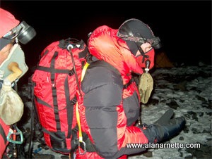
One of the most important decisions climbers make when planning an Everest climb is the use of supplemental oxygen. This is harder than it seems.
For some climbers, they will never use bottled oxygen since it creates a dependency on a system that could fail, thus increasing your risks above 8000m. Others feel it is cheating—if you cannot climb without it, you should not be there.
This debate has gone on since the practice started with the Swiss Everest climbs in the early 1920s and continues today. In any event, the vast majority of climbers today use some form of supplemental oxygen. But note that it makes an effective difference of about 3,000′ on how your body feels. So at 26,000′ you still feel like you are at 23,000 feet!
So why use oxygen at all?
First, the science. The air we breathe has a mixture of gases, including oxygen and nitrogen. The atmosphere contains about 21% oxygen at all altitudes. What changes as we go higher is the air pressure. Gravity pulls on gas molecules in the air. The closer to the Earth’s surface, the more pressure. At the summit of Everest, the pressure was measured in 1981 by a Nova team at 253 mmHG. At sea level, it is 760 mmHG. The reason for the lower pressure is that there is less atmosphere pushing down from above. This reduced pressure allows the air molecules to scatter. This means that on Everest, the air is not as dense or “thick.” In other words, there is the same amount of oxygen, but the molecules are scattered; thus, the term “thin air.” So in each breath, there is less oxygen. To be precise, about 66% less!
The critical benefit of using bottled oxygen is warmth. By reducing the work the heart and lungs have to do to keep your core warm, blood continues to flow to toes and fingers, thus reducing the risk of frostbite.
Climbers have a few choices of systems. The first is the traditional approach using a pilot’s face mask and the Russian POISK system.
The POISK system uses bottles filled at the factory in St. Petersburg, Russia (be careful of fraud with claims that bottles are new but are refilled in non-certified facilities). The oxygen is delivered through a regulator to a tube to a face mask that provides a constant flow of oxygen. They hold about 720 liters of oxygen and weigh about 5.6 lbs. Climbers usually run their flow at 2 liters per minute and count on getting about 6 hours out of a bottle. If they use more flow—3 lpm—the bottle only lasts 4 hours. Traditionally, most expeditions used POSIX cylinders, but this has changed as I’ll discuss. I used the Poisk system on Cho Oyu in 1998 and Everest in 2002 and 2003. POISK has updated their mask design, but the old models leaked and fit poorly to a climber’s face.
In the early 2000s, masks from Top Out emerged as a popular replacement for the POSIX masks, as it offers an improved mask design and uses an external reservoir. The separate reservoir claims to meet instant demands, but in my experience, the most significant improvement is that the mask fits tightly to the face, preventing leaks. It works with the POISK oxygen bottles and regulators. I used it on my 2011 Everest summit with good success; however, the mask lines did freeze up on my descent of the Hillary Step, and it took a good fist blow from my Sherpa to clear the ice. This is actually a serious issue that several of my teammates also experienced.
Today in the mid 2020s oxygen delivery systems from Summit Oxygen. I used it very successfully on Manaslu in 2013. Neil Greenwood’s Summit Oxygen offers a complete system: mask, regulator, and cylinder. It was designed from the ground up using the latest technology. He continues to improve it with incremental improvements. The complete system of cylinder, valve, regulator, and mask is the lightest-weight system on the market.
Most expeditions will assume 5 to 7 3L bottles per climber on Everest. It takes a lot of work to get the bottles positioned on the mountain. Sherpas usually cache some at C3, South Col, Balcony, and the South Summit. Obviously, they are used for the summit as well as the descent. Due to Nepal regulations on the south side, all the bottles are carried down and reused for future expeditions. The days of littering the mountain are hopefully gone forever. That said, real effort is needed to clean up the north.
On summit night, climbers put one or two bottles in their packs. The rubber tube runs over their shoulder to the mask. Some mask models interfere with visibility in that it is almost impossible to see your feet. This makes you go even slower! And the older mask designs are not 100% sealed around your face; air escapes, fogging up goggles; precious oxygen leaks from the gaps; and there is no capacity to provide extra oxygen “on-demand” during big moves.
Gasping for breath, struggling to see where you are stepping, or hauling an extra 13 lbs in the Death Zone is uncomfortable. But very few climbers would trade the discomforts for that extra 3000 feet!
Read more of my thoughts and a current review of oxygen systems for Everest at this link.
The Khumbu Cough
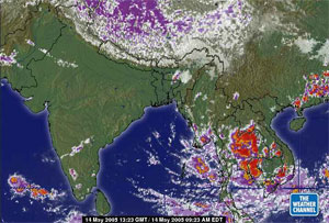
I have been to the Everest region nine times, and the Khumbu cough was my constant friend each time. Friend is a nice way of saying a constant companion—an annoying one but nonetheless a companion.
The Himalayan Rescue Association operates a medical station at Everest Base Camp— Nepal side— each spring season, and the cough is one of the most treated problems.
Basically, it occurs when air brought into the lungs is too cold and too dry. Thus, the lining of the lungs becomes inflamed and loses its ability to expel moisture and small particles. The bottom line is that in addition to an incredibly annoying cough, it hurts to breathe.
According to this exhaustive article from the National Institutes of Health: “Altitude-related cough is a troublesome condition of uncertain aetiology [cause] that affects many visitors to high altitude. The traditionally held belief that it was due solely to the inspiration of cold, dry air was refuted by observations and experiments in long-duration hypobaric chamber studies. It is likely that altitude-related cough is a symptom of a number of possible perturbations [deviations] in the cough reflex arc that may exist independently or together. These include loss of water from the respiratory tract; respiratory tract infections and subclinical high-altitude pulmonary oedema. The published work on altitude-related cough is reviewed and possible aetiologies for the condition are discussed.”
You may say, so how bad can a cough be? Well, bad enough that you cannot sleep, ribs can get broken, you cannot breathe when climbing, and bad enough that all your climbing partners make you sleep in the toilet tent! But for me, it turned into a lung infection that killed any hopes of a summit in 2002. I clearly remember standing at 27,200′ between the Balcony and the South Col, violently coughing, dry heaving, and finally having zero energy to take another step.
In the category of misery loves company, here is an excerpt from a climber in 1924:
“Finally, as we approached the level of 28,000 feet [8534 m], the summit being only half a mile away or less, I felt that, as far as I was concerned, it was hopeless to continue. I told Norton that he had no chance of the summit with me. My throat was not only extremely painful, but was getting almost blocked up—why, I knew not. . . . Somewhere about 25,000 feet [7620 m] high [on the descent], when darkness was gathering, I had one of my fits of coughing and dislodged something in my throat which stuck so that I could breathe neither in nor out. I could not, of course, make a sign to Norton, or stop him, for the rope was off now; so I sat in the snow to die whilst he walked on, little knowing that his companion was awaiting the end only a few yards behind him. I made one or two attempts to breathe, but nothing happened. Finally, I pressed my chest with both hands, gave one last almighty push—and the obstruction came up. What a relief! Coughing up a little blood, I once more breathed really freely—more freely than I had done for some days.”
For those headed up there this year, the only advice I can offer is to wear a buff, mask, or bandanna over your mouth from Namche on. Use hard candy to keep your mouth moist, try to breathe through your nose as much as possible, and stay hydrated.
Predicting the Weather on Everest
Is predicting the weather an art or science? According to Michael Fagin at EverestWeather.com it is both. Michael has provided weather forecasts for Everest climbers for many years. Ed Viesturs exclusively relied on Michael’s forecasts during his successful summit of all 14 8000m mountains.
Michael and team look at 6 different models to come up with a single forecast. They provide forecasts for most major climbing venues: Himalayas, Alps, Denali, Caucasus, Karakorum, Andes, and the US Cascades.
I asked him just how hard it is to forecast the weather on Everest and how stable is the so-called “summit window” we hear about late in each season. As Everest followers know, this is that tiny break in the weather when the jet stream moves north, thus reducing the fierce winds on Everest’s summit. Climbing teams wait for days or sometimes weeks for that window to appear.
Michael, Can you explain what is going on with the "window"?
That is the million-dollar question, not that I get a million dollars to do the forecast, but I could if I could get this right every time. However, on second thought, I truly doubt if I would ever come close to that figure even if I were perfect. I’m going to answer this question in multiple ways as it depends on teams’ needs.
Here is an example. Not that a group would be unsafe, but if it is towards the end of the season, end of May, the group might be much more amenable to so-so summit conditions; winds at 25 to 35 knots vs. winds of 10 knots. It also depends on the strength of the group. Stronger teams could handle the higher winds.
Predicting when the winds are within “safe summit conditions” is “relatively” not difficult. So predicting winds in the 25 to, say, 35 winds is not that difficult to predict as compared to the “perfect summit conditions”. However, sometimes the winds get stubborn and stay at the 40-knot range.
Finding that “perfect window“ is certainly a forecast challenge. Perfect wind being winds at, say, 6 to 20 knots is extremely difficult. For one thing, we are talking about winds in the jet stream (Everest summit) and this is the region where the winds in much of May in some seasons exceed 100 knots. So, there are just a few days in the year when winds are below 10 knots.
Another challenge is that forecasting models do not seem to resolve the wind speeds of 10 to 30 knots that well. The models many times put the winds in the 10 to 35-knot range.
Finally, as a forecaster, I have to be really careful in forecasting 10-knot winds. I have seen many times when the forecast models show winds of 10 knots and they are 40 knots. So, I have seen many times when the forecast models show winds of 40 and they are at 10 knots or even calm.
How long have you been predicting the weather for Everest?
My first forecast was in the spring of 2003. With that being the 50 anniversary of the first summit of Everest I thought that was a good time to start. Another reason I started then was some climbers wanted a forecast for of 2003 so I thought I should get the Everest weather forecast models tuned up first.
How difficult is it to predict Everest weather?
Having cut my teeth on forecasting for Mt Rainier since 1976 has certainly put mountain forecasting in perspective.With Mt. Rainier having the jet stream and the weather systems aimed it makes that a challenge and also the big source of moisture, the Sound and the ocean, close that also makes for a difficult forecast as well. Having said all that, “cutting my teeth on Rainier” made a great foundation for mountain forecasting and being able to accurately forecast for other regions but does not make Everest forecasting easy. Everest has it challenges as well and here is a very brief list of them:
– While many locations have real time weather observations Everest does not so it makes it difficult to get an exact read on what the real time weather is like. Of note there was a weather station set up on the South Col several years ago but it was difficult to keep the station running and there were some security (theft) issues.
– When a tropical storm moves in from the Bay of Bengal this type of pattern can produce copious amounts of precipitation. The problem is the forecast model output is very unreliable and at times totally understates precipitation amounts and understates the wind.
– During the post monsoon season, September and October, is tricky since the forecast models do not give a lot of advance warning when the drier and stronger winds kick in.
How do climbers get your forecasts?
I deliver in multiple ways: email to laptops, short text messages to sat. phones, leave voice mail recordings on their phones, fax forecast to office and office sends to climbers, and they can call in to get the forecast.
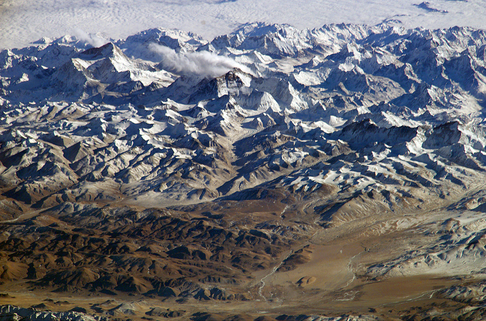
This image was taken from the International Space Station on January 28, 2004 using an 800mm lens from 200 miles above the Earth. It shows Everest (dead center of image) from the north. You can clearly see the North Face, the Western CWM, Lhotse Face, and Lhotse. The large peak on the left of the image is Makalu, 27,765′ or 8,462 m. Cho Oyu 26.907′ or 8201m is on the right middle edge. Ama Dablam is in the upper middle quadrant—bonus points for finding it! You can read more about this shot on the NASA website.
Everest Route Overview
Each Spring and Autumn, climbers will trade their warm homes and soft beds for weeks of bitter cold, extreme heat, and mind-numbing oxygen deprivation as they seek to stand on the top of the world.
After deciding to climb Everest, climbers must choose their route. There are over 18 named routes on Everest and a couple that are still unclimbed. The vast majority of climbers use two routes: South Col or the Northeast Ridge Standard, aka North Col route. Both sides have their pros and cons. Up until 2007, the trend was for more climbers to choose the north due to lower costs. But with the Chinese restricting permits over the past few years, the south side has retained the lead as the preferred route, primarily due to commercial operators wanting to reduce uncertainty and to limit their risks. Let’s briefly compare both sides:
South Col Route
| Pluses | Concerns |
| Beautiful trek to base camp in the Khumbu | Khumbu Icefall instability |
| Easy access to villages for pre-summit recovery | Crowds, especially on summit night |
| Helicopter rescue from base camp if necessary | Cornice Traverse exposure |
| Slightly warmer sometimes with less winds | Slightly longer summit night |
Northeast Ridge Route
| Pluses | Concerns |
| Less crowds | Colder temps and harsher winds |
| Can drive to base camp | Camps at higher elevations |
| Easier climbing to mid-level camps | A bit more difficult with smooth or loose rocks |
| Slightly shorter summit night | No opportunity for helicopter rescue at any point |
Now let’s take an in-depth look at both sides
South Col Route
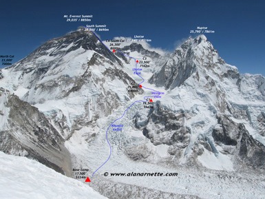
Mt. Everest was first summited by Sherpa Tenzing Norgay and New Zealander Edmund Hillary with a British expedition in 1953. They used the South Col route. At that time, the route had only been attempted twice by Swiss teams in the spring and autumn of 1952. They reached 8500m well above the South Col. Of note, Norgay was with the Swiss, thus giving him the experience he used on the British expedition. The Swiss returned in 1956 to make the second summit of Everest. Here is a typical south side climb schedule showing average time and the distance from the previous camp plus a brief description of each section. More details can be found on the South Col route page.
- Base camp: 17,500’/5,334 m
- Home away from home. Located on a moving glacier, tents can shift and platforms melt. The area is harsh but beautiful, flanked by Pumori and the Khumbu Icefall with warm mornings and afternoon snow squalls. With so many expedition tents, pathways, music blaring, and generators, it feels like a small village. In the mid-2020s, over 1,500 people can be there each April and May.
- C1: 19,500’/5,943 m – 4–6 hours, 1.62 miles
- Reaching C1, can be the most challenging part of a south climb since it crosses the Khumbu Icefall. The Icefall is 2,000′ of moving ice, sometimes as much as 3 feet a day. But it is the deep crevasses, towering ice seracs, and avalanches off Everest’s West Shoulder that create the most danger. IN 2014, sixteen Sherpas were killed when a piece of ice fell from Everest’s West Shoulder and collapsed on top of them in the Icefall.
- C2: 21,000’/6,400m – 2–3 hours, 1.74 miles
- The trek from C1 to C2 crosses the Western CWM and can be laden with crevasse danger. But it is the extremely hot temperatures that take a toll on climbers. Again, avalanche danger exists from Everest’s West Shoulder or Pumori, which has dusted C1 in recent years.
- C3: 23,500’/7,162m – 3–6 hours, 1.64 miles
- Climbing the Lhotse Face to C3 is often difficult since almost all climbers are feeling the effects of high altitude and traditionally (but this is changing) are not yet using supplemental oxygen. The Lhotse Face is steep and the ice is hard. The route is fixed with rope. The angles can range from 20 to 45 degrees. It is a long climb to C3 but traditionally (but this is changing) is required for acclimatization prior to a summit bid. There are usually several C3 locations in the same general area.
- Yellow Band: 24,500/7,467m – 2–3 hours
- The route to the South Col begins at C3 and across the Yellow Band. It starts steep but settles into a sustained grade as the altitude increases. Climbers are usually in their down suits and are using supplemental oxygen. The Yellow Band’s limestone rock itself is not difficult climbing but can be challenging given the altitude. Bottlenecks can occur on the Yellow Band.
- Geneva Spur: 26,000’/7,924m – 1–2 hours
- This section can be a surprise for some climbers. The top of the Spur leading onto the South Col has some of the steepest climbing thus far. It is easier with a good layer of snow than on the loose rocks.
- South Col: 26,201’/7,986m – 1 hour or less
- Welcome to the moon. This is a flat area covered with loose rock and surrounded by Everest to the north and Lhotse on the south. Generally, teams cluster tents together and anchor with nets or heavy rocks against the hurricane-force winds. This is the staging area for the summit bids and the high point for Sherpas to ferry oxygen and gear for the summit bid. Sadly, today human fecess litter the area.
- Balcony: 27,500’/8,282m – 4–5 hours
- Officially now on Everest, climbers are using supplemental oxygen to climb the steep and sustained route up the Triangular Face. The route is fixed with rope, and climbers create a long conga line of headlamps in the dark. The pace is maddeningly slow, complete with periods of full stop while climbers ahead rest, consider the decision to turn back or continue to the balcony. It can be rock or snow depending on the year. Rock fall can be a deadly issue, and climbers wear helmets. They swap oxygen bottles at the Balcony while taking a short break for food and water.
- South Summit: 28,500’/8,690m – 2 to 4 hours
- I consider this section the crux of the Southeast Ridge route. The climb from the Balcony to the South Summit is steep and continuous. While mostly on a beaten-down boot path, it can be challenging near the South Summit with exposed slabs of smooth rock in low snow years. The views of Lhotse and the sun rising to the east are indescribable at this point.
- Hillary Step (slope): 28,740’/8,770m – 1 hour or less
- One of the most exposed sections of a south side climb is crossing the cornice traverse between the South Summit and the Hillary Step. But the route is fixed and wide enough that climbers rarely have issues. After the 2015 earthquake, the Hillary Step is no longer a short 40′ section of rock climbing, but rather a relatively mellow snow slope. However, it may be a soft cornice that can collapse and take lives as it did in 2024. It is fixed with rope, which creates a bottleneck on crowded summit nights. Usually, but not always, there is an up and down climbing rope to keep people moving.
- Summit: 29,032’/8,848m – 1 hour or less
- The last section from the Hillary Step to the summit is a moderate snow slope. While tired, climbers’ adrenaline keeps them going.
- Return to South Col: 3–7 hours
- Care must be taken to avoid a misplaced step down climbing from the summit, across the Cornice Traverse, or the slabs below the South Summit. Also, diligent monitoring of oxygen levels and supply is critical to make sure the oxygen lasts back to the South Col.
- Return to C2: 4 hours
- Usually, climbers are quite tired but happy to be returning to the higher natural oxygen levels regardless of their summit performance. It can be very hot since most climbers are still in their down suits.
- Return to base camp: 4 hours.
- Packs are heavy since everything they hauled up over the preceding month must be taken back down. It is now almost June, so the temperatures are warmer, making the snow mushy, thus increasing the difficulty. But each step brings them closer to base camp comforts and on to their home and families.
For a more detailed description and animated route map, please see the South Col route page.
Northeast Ridge Route
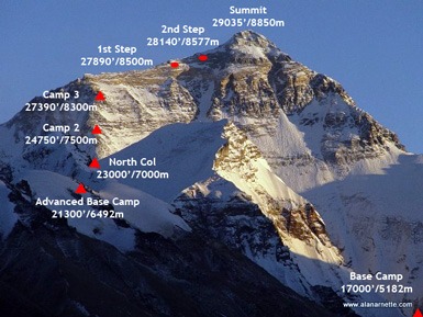
The north side of Everest is steeped in history with multiple attempts throughout the 1920s and 1930s. The first attempt was by a British team in 1921. Brit, George Mallory led a small team to be the first human to set foot on the mountain’s flanks by climbing up to the North Col (7003 m). The second expedition, in 1922 reached 27,300′ before turning back and was the first team to use supplemental oxygen. It was also on this expedition that the first deaths were reported when an avalanche killed seven Sherpas.
The 1924 British expedition with George Mallory and Andrew “Sandy” Irvine is most notable for the mystery of whether they summited or not. If they did summit, that would precede Tenzing and Hillary by 29 years. Mallory’s body was found in 1999 and Irvine’s foot inside his boot on the Tibet side low on the Central Rongbuk Glacier in September 2024, but neither discovery shed any light on the summit question.
A Chinese team made the first summit from Tibet on May 25, 1960. Nawang Gombu (Tibetan) and Chinese Chu Yin-Hau and Wang Fu-zhou, who is said to have climbed the Second Step in his sock feet, claimed the honor. In 1975, on a successful summit expedition, the Chinese installed the ladder on the Second Step.
Tibet was closed to foreigners from 1950 to 1980 preventing any further attempts until a Japanese team summited in 1980 via the Hornbein Couloir on the North Face. The north side started to attract more climbers in the mid-1990s and today is still less popular than the South side as the Chinese randomonly close Tibet for foreign climbers.
Now let’s look at a typical north side schedule showing average time from the previous camp plus a brief description of each section. More details can be found on the Northeast Ridge route page.
- Base camp: 17,060’/5,200m
- Located on a gravel, dirt-covered, dusty area near the Rongbuk Monastery, this is the end of the road. All vehicle-assisted evacuations start here. There are no helicopter rescues or evacuations on the north side or for any mountain in Tibet.
- Interim camp: 19,000’/5,800m – 5 to 6 hours (first time)
- Used on the first trek to ABC during the acclimatization process, this is a spot where a few tents are placed. Usually, this area is lightly snow-covered or not at all.
- Advanced Base Camp: 21,000’/6,400m – 6 hours (first time)
- Many teams use ABC as their primary camp during the acclimatization period, but it is quite high. This area can still be void of snow but offers a stunning view directly at the North Col. It is a harsh environment and a long walk back to the relative comfort of base camp or Tibetan villages. Yaks ferry gear to ABC.
- North Col or C1: 23,000’/7,020m – 4 to 6 hours (first time)
- Leaving Camp 1, climbers reach the East Rongbuk Glacier and put on their crampons for the first time. After a short walk, they clip into the fixed line and perhaps cross a few ladders that are placed over deep glacier crevasses. The climb from ABC to the North Col steadily gains altitude with one steep section of 60 degrees that will feel vertical. Climbers may use their ascenders on the fixed rope. Rappelling or arm-wrap techniques are used to descend this steep section. Teams will spend several nights at the Col during the expedition.
- Camp 2: 24,750’/7,550m – 5 hours
- Mostly a steep and snowy ridge climb that turns to rock. High winds are sometimes a problem, making this a cold climb. Some teams use C2 as their highest camp for acclimatization purposes.
- Camp 3: 27,200’/8,300m – 4 to 6 hours
- Teams place their Camp 3 at several different spots on the ridge since it is steep, rocky, and exposed. Now using supplemental oxygen, tents are perched on rock ledges and are often pummeled with strong winds. This is higher than the South Col in altitude and exposure to the weather. It is the launching spot for the final summit push.
- Yellow Band: 27,500’/8,382m
- Leaving C3, climbers follow the fixed rope through a snow-filled gully, part of the Yellow Band. From here, climbers take a small ramp, leave the “exit cracks” around 8,350 meters and reach the northeast ridge proper.
- First Step: 28,100’/8564m
- The first of three rock features. The route tends to cross to the right of the high point, but some climbers may rate it as steep and challenging. This one requires good footwork and steady use of the fixed rope in the final gully to the ridge.
- Mushroom Rock -28,047’/8,549m – 2 hours from C3
- A rock feature that spotters and climbers can use to measure their progress on summit night. Oxygen is swapped at this point. The route can be full of loose rock here, adding to the difficulty with crampons. Climbers will use all their mountaineering skills.
- Second Step: 28,140’/8,577m – 1 hour or less
- This is the crux of the climb with the Chinese Ladder. Climbers must first ascend about 10′ of rock slab, then climb the near-vertical 30′ ladder. This section is very exposed with a 10,000′ vertical drop. It is more difficult to navigate on the descent since you cannot see your foot placement on the ladder rungs. This brief section is notorious for long delays, thus increasing the chance of frostbite or AMS.
- Third Step: 28,500’/8,690m – 1 to 2 hours
- The easiest of the three steps but requires concentration to be safe.
- Summit Pyramid – 2 to 4 hours
- A steep snow slope, often windy and brutally cold; climbers feel very exposed at this point. Towards the top of the Pyramid, climbers are extremely exposed again as they navigate around a large outcropping and experience three more small rock steps on a ramp before the final ridge climb to the summit.
- Summit: 29,032’/8,848m – 1 hour
- The final 500′ horizontal distance along the ridge to the summit is quite exposed. Slope angles range from 30 to 60 degrees.
- Return to Camp 3: 7–8 hours
- The down climb takes the identical route. Early summiters may experience delays at the 2nd Step with climbers going up or summiters having down-climbing issues.
- Return to ABC: 3 hours
- Packs can be heavy since everything hauled up over the preceding month must be taken back down. It is now almost June, so the temperatures are warmer, making the snow mushy, thus increasing the difficulty. But each step brings them closer to base camp comforts and on to their home and families.
For a more detailed description and route pictures, please see the Northeast Ridge route page.
Summary
Each year is different on Everest. The temperatures can be colder or hotter, winter snows more or less, and of course, the wildcard is when the jet stream moves off the summit. Predicting Everest weather is difficult at best.
Experts around the world send daily updates to expedition leaders who analyze the reports as compared with what they are seeing. When the winds are predicted to be under 25 m.p.h. over a 48-hour period, teams set off for the top of the world.
So which side is easier? As I always say, pick your poison. The south has the Icefall; the north, the exposed northeast ridge and the Steps. In spite of the Icefall dangers, I think most operators will say the south side is safer and slightly easier. One sobering statistic backs up this advice—more climbers, by a 2:1 ratio, have died on the north than the south since 2000 as I explained in this earlier post.
But the real answer is no one knows for certain what each season will bring. So train hard, get skills on low mountains and altitude experience on another 8000m mountain before Everest, and go with a team you can count on in an emergency.
Climb On!
Memories are Everything
Alan
Preparing for a Climb is More Than Training
Summit Coach
From Your First Summit to Everest. One Coach, the Whole Way.
Planning your next big climb? Work one-on-one with Alan Arnette, Everest and K2 summiteer, for personalized training plans, independent guide-service advice, gear recommendations, and experienced support from preparation through expedition.
No commissions. No conflicts. Just advice focused on your success.
www.alanarnette.com is provided for informational purposes only and not for advice except through Summit Coach services.
Please see the complete disclaimer.