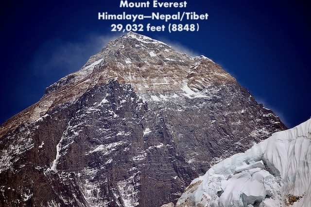
Everest Northeast Ridge aka North Col Route
Everest Home | Pictures | Climbs | Coverage | Statistics | Essays | Extras | F.A.Q. | Links
I summited Everest on May 21, 2011 and have climbed it three other times (all from Nepal) – 2002, 2003 and 2008, each time reaching just below the Balcony around 27,500′ (8,400 meters) before health, weather, or my own judgment caused me to turn back. I attempted Lhotse twice – 2015 and 2016. When not climbing, I cover the Everest season from my home in Colorado as I did for the 2004, 2005, 2006, 2007, 2009, 2010, 2012, 2013, 2014, 2015, 2016, 2017, 2018, 2019, a virtual 2020 season, 2021, 2022, 2023, 2024, 2025, 2026 and soon the 2027 season.
Follow Alan Arnette’s Annual Everest Coverage
“One of the world’s most respected chroniclers of Everest” — Outside Magazine
Read the Latest Season Coverage
Read the Latest Everest Statistics—summits, deaths, by sides, climbers
Sign up for post’s notification
This page is about Mt. Everest Northeast Ridge (North Col Route)
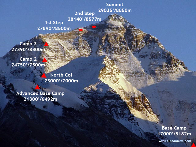
Click the map to enlarge. These images are protected by copyright. Please read this for use information.
Elevations and Times Between Camps (approximate)
Typical Climb Schedule (approximate)
- Base Camp: 17,060′ / 5,200m
- Interim Camp: 19,000′ / 5,800m – 5 to 6 hours (first time)
- Advanced Base Camp: 21,000′ / 6,400m – 6 hours (first time)
- North Col or C1: 23,000′ / 7,020m – 4 to 6 hours (first time)
- Camp 2: 24,750′ / 7,550m – 5 hours
- Camp 3: 27,200′ / 8,300m – 4 to 6 hours
- Yellow Band: 27,500′ / 8,382m
- First Step: 28,100′ / 8,564m
- Mushroom Rock: 28,047′ / 8,549m – 2 hours from C3
- Second Step: 28,140′ / 8,577m – 1 hour or less
- Third Step: 28,500′ / 8,690m – 1 to 2 hours
- Summit Pyramid: 2 hours
- Summit: 29,032′ / 8,848m – 1 hour
- Return to Camp 3: 7-8 hours
- Return to ABC: 3 hours
- March 29 – Arrive Kathmandu, Nepal
- March 30, 31 – Kathmandu
- April 1 – Fly to Lhasa, Tibet (12,000 ft)
- April 6-7 – Lhasa sightseeing (begin acclimatization)
- April 8 – Drive to Shigatse (12,500 ft)
- April 9 – Drive to Tingri (Shegar) (13,800 ft)
- April 10 – Drive to Everest Base Camp (BC) (17,060 ft)
- April 11-13 – Set up BC and acclimatize
- April 14 – Trek to Interim Camp (IC) (19,000 ft)
- April 15 – Arrive at Advanced Base Camp (21,000 ft)
- April 16 – May 27 – Climbing Period (Camps 2 & 3, Summit)
- May 28 – Return to Advanced Base Camp (ABC)
- May 29 – Return to Base Camp (BC)
- May 30 – Disassemble BC
- May 31 – Drive to Nyalam, Tibet
- June 1 – Drive to Kathmandu
- June 2, 3, 4 – Weather days or back in Kathmandu
- June 5 – Depart for home
Overview
The north side of Everest is steeped in history with multiple attempts throughout the 1920’s and 1930’s. The first attempt was by a British team in 1921. Mallory led a small team to be the first humans to set foot on the mountain’s flanks by climbing up to the North Col at 7,020m/23,031 feet. The second expedition, that of 1922, reached 8,321m/27,300 feet before turning back, and was the first team to use supplemental oxygen. It was also on this expedition that the first deaths were reported when an avalanche killed seven Sherpas.
It was a Chinese team who made the first summit from Tibet on May 25, 1960. Nawang Gombu (Tibetan) and Chinese Chu Yin-Hau and Wang Fu-zhou, who is said to have climbed the Second Step in his sock feet, claimed the honor. However without a summit photo, many doubted the summit claim. In 1975, a successful summit was claimed by the Chinese when the ladder on the Second Step was installed.
Tibet was closed to foreigners from 1950 to 1980 preventing any further attempts until a Japanese team summited in 1980 via the Hornbein Couloir on the North Face.
Note that in modern times, post-2020, the use of hypoxic tents for “pre-acclimatization” at home, high rates of supplemental oxygen, and support ratios for clients have reduced the length of expeditions from two months to as little as two weeks, with the average expedition length on the Tibet side in Spring around 37 days.
The Mallory and Irvine Mystery
The 1924 British expedition with George Mallory and Andrew “Sandy” Irvine is most notable for the mystery of whether they summited or not. If they did summit, that would precede Tenzing and Hillary by 29 years. Mallory’s body was found in 1999 and Irvine’s foot inside his boot on the Tibet side low on the Central Rongbuk Glacier in September 2024, but neither discovery shed any light on the summit question.
But it is who summited first that dominates Everest folklore. Was it Mallory and Irvine in 1924, or Tenzing and Hillary as we know in 1953? Some even speculate it was British climber Maurice Wilson in 1933.
With the mystery dominating Everest gossip for almost a century, teams have looked in vain for positive proof of a 1924 summit. There have been valiant efforts throughout the years. In 1933, Irvine’s wooden ice axe was found in the fall line of the climbers’ last known route. A Chinese porter reported seeing an “English dead” in 1960 but there were no pictures.
Then in 1999, a team led by IMG founder Eric Simonson conducted a serious search. Conrad Anker found Mallory’s body on the north side below the Chinese reported location. Neither Irvine’s body nor the camera was located. Simonson returned in 2001 to look for the camera, without success. It was the classic needle in the haystack search complicated by snow cover.
While the discovery of Mallory’s body and Irvine’s foot created excitement throughout the climbing world, it did not provide any evidence of a summit. In fact, it just fueled the speculation. Multiple expeditions have searched for the camera and summit clues:
- 1933 British Mount Everest Expedition: Led by Hugh Ruttledge, this expedition found an ice axe belonging to either Mallory or Irvine lying on the rock slabs of the Northeast Ridge, high above Camp VI.
- 1975 Chinese Mount Everest Expedition: Chinese climbers made a major ascent and reportedly spotted a body (often believed to be Irvine), though official details remained sparse for decades.
- 1986 Tom Holzel Expedition: An early independent search attempt led by historian Tom Holzel used analysis of historical photographs to re-evaluate where the climbers might have fallen.
- 1999 Mallory and Irvine Research Expedition: Led by Eric Simonson and featuring climber Conrad Anker, this team found George Mallory‘s well-preserved body on May 1, 1999, at 26,760 feet on the North Face. They recovered personal items, an altimeter, and an oxygen cylinder (No. 9), but did not find Irvine or the camera.
- 2001 Mallory and Irvine Research Expedition: Returning to the North Face, this team searched higher camps and ridges, finding a woolen box-cloth glove (believed to belong to one of the 1924 climbers) near the Yellow Band, though the camera remained elusive.
- 2004 & 2007 Expeditions: Follow-up tactical sweeps and localized searches yielded historical debris, oxygen gear fragments, and mapping data, but no camera or final proof of the summit.
- 2013 Tom Holzel / High-Resolution Flyover Analysis: Holzel used high-altitude aerial and satellite image comparisons to re-examine potential coordinates and pinpointed a target area (“oblong blob”) near the 1975 Chinese sighting zone, though a physical expedition failed to materialize immediately.
- 2018 Michael Tracy, along with Arnold Coster and Richard Thomas Maybank, searched above Camp IV and 3 for ten hours before returning to base camp.
- 2019 Mark Synnott searched in a similar area to the 2004 search.
- 2024 National Geographic Expedition: A team including filmmaker Jimmy Chin searched glacial melt zones and discovered partial human remains—specifically a foot inside a sock and boot labeled “A.C. Irvine”—emerging from the Central Rongbuk Glacier, though the camera was not recovered.
The Route, Camp by Camp
Photos courtesy of Big Green Everest. Click any photo to enlarge.

Base Camp (17,060'/5,200m) to Advanced Base Camp (21,000'/6,400m)
From BC to ABC it is about 12 miles (22km) of rugged hiking on boulders, ice, and snow. The route follows the Rongbuk Glacier until it merges with the East Rongbuk Glacier. ABC is on the northwestern side moraine of the East Rongbuk Glacier, under the slopes of Changtse.
It normally takes 2 days for the first trip to ABC, stopping at an interim camp. Once acclimatized, the trek takes 1 day. ABC is the primary High Camp home for Northeast Ridge climbers during the expedition. Climbers use the lower Base Camp for rest and preparation prior to their summit bid.

ABC to the North Col, Camp 1 (23,000'/7,000m)
The North Col camp is a 2,200′ climb from ABC. Leaving ABC, climbers reach the East Rongbuk Glacier and put on their crampons for the first time. After a short walk, they clip into the fixed rope.
The climb from ABC to the North Col steadily gains altitude with one steep section of 60 degrees that will feel vertical. Climbers are clipped into the fixed rope and use their ascenders. Rappelling is used to descend this section. A few ladders may be placed over deep crevasses.
It takes between 4 to 7 hours to reach the North Col depending on acclimatization and weather.

Camp 1 to Camp 2 (24,750'/7,550m)
C2 starts the “High Camps.” The route is usually pure snow but can be rock since this section is known for high winds.
It should take about 3 to 5 hours to reach C2. Some teams use this as their highest camp for acclimatization purposes.

Camp 2 to Camp 3 (27,200'/8,300m)
Some expeditions do not use a Camp 3 and go directly to 8,300 m. Above 8,000 m, most climbers now sleep on supplemental oxygen.
The climb is extremely windy, and the tents are on small rock ledges since there are limited large and level areas. At Camp 3, the wind is usually blocked by the North Face of Everest, so sleeping is easier. Climbers will take 3 to 6 hours to reach C3.
This is equivalent to the South Col in altitude and exposure to the weather.

Camp 3 to Camp 4 (27,390'/8,300m)
Camp 4 (or Camp 3 if the previous camp is skipped) is a short rest stop on the way to the summit for most climbers. At 27,390′, you do not want to spend a lot of time here. Climbers will have some food and water, perhaps a short nap, and start for the summit around 10:00PM.
Leaving the high camp, climbers follow the fixed rope through a snow-filled gully, part of the Yellow Band. From here, climbers take a small ramp and reach the Northeast Ridge proper.
The Northeast Ridge is a few hundred feet above C4.

Camp 4 to the Second Step 28,140'/8,577m
The Northeast Ridge represents the most difficult climbing on this route. There are three “steps” or rock climbs along the way.
The 1st Step, the first of three rock features, is difficult at this altitude. The route tends to cross to the right of the high point. Some climbers may rate it as steep and challenging. It requires hard pulling on the fixed ropes in the final gully to the ridge.
Mushroom Rock is a feature on the ridge that spotters and climbers can use to measure their progress on summit night. Oxygen is swapped here. The route can be full of loose rock, adding to the difficulty with crampons.
The 2nd Step is the crux of the climb with the Chinese Ladder. Climbers must first climb about 10′ of rock slab, then climb the near-vertical 30′ ladder. This section is very exposed with a 10,000′ vertical drop.
It is more difficult to navigate on the descent since you cannot see your foot placement on the ladder rungs. This brief section is notorious for long delays, thus increasing the chance of frostbite or AMS.

Second Step to the Summit
The 3rd Step at 28,500′ / 8,690 m is a straightforward rock climb but challenging at this altitude (nothing is easy anymore). Climbers now spend the next hour climbing the steep snowfields of the Summit Pyramid.
It is a steep snow slope, often windy and extremely cold, and climbers feel very exposed. Towards the top of the Pyramid, climbers are extremely exposed again as they navigate around a large outcropping and experience three more small rock steps on a ramp before the final ridge climb to the summit.
The Summit Ridge is the final 500′ horizontal distance along the ridge to the summit and is quite exposed. Slope angles range from 30 to 60 degrees. It is narrow with 10,000′ drop-offs on both sides leading directly to the Everest summit.
Now the climbers have spent 8 to 10 hours to summit. It will take another 4 to 6 to return to C3.
Go To The Summit
See this excellent 2007 first person description of this route from Philippe Gatta.
For deep insight into an Everest expedition, download Everest 2011: Summit of Memories, the report of my 2011 south side summit climb. It is a free PDF.
Preparing for a Climb is More Than Training
Summit Coach
From Your First Summit to Everest. One Coach, the Whole Way.
Planning your next big climb? Work one-on-one with Alan Arnette, Everest and K2 summiteer, for personalized training plans, independent guide-service advice, gear recommendations, and experienced support from preparation through expedition.
No commissions. No conflicts. Just advice focused on your success.
www.alanarnette.com is provided for informational purposes only and not for advice except through Summit Coach services.
Please see the complete disclaimer.