Ben Nevis FAQ

Ben Nevis FAQ
Vinson FAQ

Antarctica 16,067′,4897 meters Summited December 9, 2010 7 Summits Climb for Alzheimer’s About Vinson Q: Where is Vinson A: 600 miles from the South Pole, Mount Vinson was first summited in 1966 by climbers led by Nicholas Clinch from the American Alpine Club and the National Science Foundation. It was the last of the 7 Summits to be summited. It was named after US Senator and Antarctica supporter Carl Vinson. It is in the Sentinel range of the Ellsworth Mountains. Just getting there is an adventure. The flight previously was a four-hour, 20,000-mile trip on a Russian Ilyushin 76 cargo plane, but today (2025) is a sleek 757 outfitted with Business Class seating throughout the plane starting from the tip of South America to the snow camp of Union Glacier. Once there, climbers are ferried another 35 minutes via a Twin Otter to Vinson base camp Q: When is it usually climbed? A: Climbs usually take place between December and February. – the 24 hours of sunlight a day in summer in Antarctica. Q: I understand that Vinson is easy. A: It is straightforward, with mostly glacier travel, but the climbing is not Vinson’s challenge; it is the weather and the logistics of getting in and out of Antarctica. Q: How does Vinson compare with Denali or Rainier? A: It is easier than Denali since it is shorter—if the weather is not brutal. We sat in our tents at Low Camp for six days, waiting for 50 mph winds to ease on the summit ridge. Like Denali, you pull a sled with personal and group gear, but the loads are lighter. Even though the summit is about 16,000′, the effective altitude is about 2,000′ higher. Q: Is a Vinson climb dangerous? A: Absolutely. While there have been no deaths on Vinson, which is remarkable, there are cases of severe frostbite. The primary issue is that in case of a life-threatening emergency, it could take days or weeks to get you back to a hospital, given the severe weather conditions. Q: How many people had summited, and how many people had died trying? A: An estimated 1,200 climbers have summited Vinson at an extremely high success rate. There have been no deaths. Training, Gear & Communication: Q: How did you train for this climb? A: I usually climb my local Colorado 14ers, plus daily workouts with weights and on an elliptical machine. Q: Was altitude a problem on this climb? A: It’s not a big issue, given that it is 16,000′. However, the barometric pressure is quite low at both Poles, so the available oxygen per breath is lower than at the given altitude compared to other big mountains. Thus, from a cardiovascular perspective, it felt like it was 18,000′. Q: What kind of equipment did you use? A: Mostly, I use the same gear I used on Everest—lots of layers. My technical equipment included a long-handle ice axe, harness, carabineers and crampons. Protecting my toes, fingers and face is critical since they are most susceptible to frostbite. As for warmth, I always wear a knit cap and at least liner gloves when I get the least bit cool – regardless of the outside temp. I use a three-layer system of Merino wool base layer (top and bottom), heavier fleece as in a Farmer’s John kind of suit or just my Gortex Pants, depending on how cold it is that day, then my top wind or warmth layer e.g. Patagonia Micro Puff and/or JetStream Shell. When the winds pick up, and the temps hover at -30F, I add an 850 Fill Down jacket plus my mitts, which I never used on Vinson. Q: Is anything special in your gear for Vinson? A: I took almost all my extreme weather gear except the full-down suit. It can be extremely cold and windy, so multiple down layers are required. My boots were the Kayland 8001, an integrated gator boot with a separate inner boot similar to the Millets or Olympus Mons. Some people climbed in double plastics with overboots. I was never cold. I was pleased when I used a new sleeping bag from Mountain Hardwear, the Wrath -20—I also used the ExPed Down mat 9 on top of a Z-pad. I was warm and comfortable. Q: Did you use a satellite phone? A: I used an Iridium phone with good results to post updates to this website. Expedition Basics Q: Which route is most prevalent? A: There is only one primary route from the west side, which follows the Branscomb Glacier and has two intermediate camps. In 2001, a team climbed via the East Face. In late 2008, one team climbed to the Shinn Col via the Dater/Hinckley glaciers before joining the regular route. Q: How long will it take? A: A Vinson climb can be incredibly short. With zero weather delays, you can arrive at Union Glacier, fly to Vinson Base Camp, climb to Low Camp, then High Camp and summit, plus return in about a week. But this seldom occurs. Count on three weeks with weather delays. Q: How much does a standard climb cost with and without a guide? A: For 2025, the costs are around $55,000. The cost is so high due to the logistics of getting to Antarctica. Once you are there, you can see why. Q: Do I need a permit to climb? A: There are no permits, but you must use Antarctic Logistics and Expeditions(ALE) to fly to Antarctica since they are the only ones allowed to fly there. Q: Do I need a guide for Vinson? A: ALE requires a guide to climb unless they approve you as an exception with proper experience and a team of 3 or more—don’t count on it. They can provide a guide, or any other guide company will provide one. In my opinion, you must bring a two-way radio and a satellite phone and have the frequency or number of the local rescue resources already programmed in. Q:
Kosciuszko FAQ

Australia 7,310 feet/2229 meters Summited October 27, 2011 7 Summits Climb for Alzheimer’s About Kosciuszko Q: Where is it A: Known historically as Tan Gan Gil, “Kozzy” is located in Australia in New South Wales and is also a local ski area in the Kosciuszko National Park. The nearest largest city is Canberra, equidistant between Sydney and Melbourne (6-8 hour drive). Mount Kosciuszko is part of the Snowy Mountains in the Great Dividing Range. The first recorded ascent was in 1840 by Polish explorer Paul Strzelecki. Still, according to local information, it was most likely climbed (hiked) for centuries by the local First Nation people of the Monaro. It is sometimes considered the highest in Oceania, but Carstensz Pyramid holds that honor. Q: When is it usually climbed (hiked)? A: Due to the lack of snow, the typical climbing season is Australia’s summer ( November to May), but it can be climbed (hiked) year-round with proper equipment. From June through October, hikers should plan on dealing with snow. The summit was snow-covered for my hike in mid-October. The best time to hike Kozzie is in Australia’s summer months of December through February, but March and April, plus October and November, also offer nice weather. Q: I understand that Kosciuszko’s is just a simple walk-up. How hard is it? A: In winter, it can test your skills. While it can be hiked year-round, winter offers more of an alpine experience, and you will need proper clothing and gear to be safe. While not a hiking or climbing accident in 1999, four snowboarders were caught in an unexpected storm and lost their lives in a snow cave in Kozi. The group and their bodies were discovered in November after they had been missing since August. On August 14, 1928, W. Evan Hayes and W. Laurie Seaman departed Charlotte’s Pass and were never seen alive again. Finally, in 2024, in 2022, a backcountry skier, Andrew Seton, died in Kosciuszko National Park. Q: How does Kosciuszko compare with the other 7 Summits? A: It is the easiest of them all and very enjoyable. Kosciuszko National Park is a beautiful environment; if desired, you can enjoy all the comforts of a world-class ski resort. Q: Is a Kosciuszko climb dangerous? A: It can be if the weather turns on you. I have heard many stories from other 7 Summit climbers about being lost or struggling with high winds, deep snow or drifts. So, weather monitoring is essential, just like any outdoor activity. Q: How many people had summited, and how many people had died trying? A: It is estimated that over 100,000 people hike Kosciuszko each year. There has been a rare death in the area, mainly in the winter. Training, Gear & Communication: Q: How did you train for this climb? A: This was part of my 7 Summits Climb for Alzheimer’s: Memories are Everything® project. So, I climbed (hiked) almost continuously throughout 2010 and 2011, either in training or on the climbs. I was in excellent physical and mental condition for this climb. But I suggest the usual training regime of running, lightweight and aerobic conditioning. Q: Was altitude a problem on this climb at 7,000′? A: Not really, even for the people I observed walking up. However, it can always be a surprise. Many people feel that some type of AMS is above 8,000. As I mentioned, I had already climbed (hiked) seven other 7 Summits peaks in the previous 11 months, plus Carstensz four days before, so I was in excellent condition and never felt the altitude. Q: What kind of equipment did you use? A: I used simple trekking clothing but carried a warmth and wind layer in my pack, plus a pair of gloves and a knit hat, the same gear I used on the lower parts of Kilimanjaro. Q: Is there anything unique in your gear for Kosciuszko? A: Not really, just a good pair of sunglasses because I had excellent weather in mid-October with temps in the high 60sF. I would carry bug spray in the summer. But Kosciuszko can sometimes be extremely cold and windy, so multiple layers are required. My boots were the Montrail High Top and were fine for the snow-covered sections near the summit. Q: Did you use a satellite phone? A: I used an Iridium phone to post dispatches on this site. Cell phone connections are available. Expedition Basics Q: Which route is most prevalent? A: There are two primary routes to summit Kozzie, with the most popular starting at Thredbo Alpine Village. From there, you can take the Kosciuszko Express Chairlift to begin the 8-mile round trip Kosciuszko Walk, aka Summit Walk, a gain of 6,354′ to 7,310′. The “trail” is a metal walkway that protects the delicate alpine environment. The gain is a gentle 991 feet or 302 meters. The second main route from Charlotte Pass (6,026′) is longer (11 miles round trip) and follows a dirt road. The third and least known is the Hannels Spur Track, 9.5 miles, with the largest vertical gain in Australia at 5,900 feet. It crosses Rawson’s Pass, intersecting with the Thredbo ski ascent route. The gain is 1,273 feet or 388 meters. Thanks to reader Stewart Aickin for updating me on this route. He adds that the Hannels Spur Track was the same route that explorer Sir Paul Strzelecki climbed and ‘discovered’ Mt. Kosciusko in 1840. It is also the same route that the cattlemen once used to annually muster the cattle up from the Murray Valley to the high country (around Kosi.) to graze throughout the summer. The many indigenous tribes from the Murray Valley also used this same route annually for 1000s of years to climb Kosciuszko to feast over the summer months on the ‘delicacies’ of Bogong moths. It approaches Mt. Kosciuszko from the NW – with the trailhead near Geehi. (Geehi is a simple camping area on the Alpine Way road). Q: How long will it take? A: Depending
KIlimanjaro FAQ

One of my 7 Summits for Alzheimer’s climb – Africa’s Kilimanjaro and a safari.
Elbrus FAQ

FAQ for the highest in Eruope, Mt. Elbrus
Denali FAQ
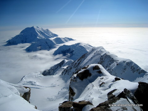
These are FAQ from my three Denali climbs
Mont Blanc FAQ

Mont Blanc France/Italy 15,771 feet – 4807 meters About Mont Blanc : Q: Where is it A: It is located in the French Alps on the border between Italy and France. It is actually “owned” by both countries under a bilateral agreement and is called Monte Bianco in Italy. Mont Blanc is a huge massif and the tallest peak on the massif. The nearest airport is Geneva, Switzerland. It is about an hour’s drive or by train to Chamonix, France. Q: When is it usually climbed? A: As with most Northern Hemisphere peaks, Summer is best because every day is warmer with less threat of snow. I climbed it in July and August. But in recent years, ~2022-2025, the summer has been so hot that local guides stopped climbing it. Q: How hard is it? A: There are many routes that can vary from extremely difficult and technical to semi-technical. This means ropes, crampons and ice axe. Due to the danger of crevasse, you usually rope up in teams. The ice climbing can be WF4 for short sections. My personal experience was mixed. I found it very challenging the first time due to an extremely long day – 13 hours. The other times, it became easier with my improved conditioning and experience. I used a Guide from Chamonix on the first climb and climbed alone on the other two. Q: How does Mont Blanc compare with Denali or Mt. Rainier? A: It is a serious climb where climbers experience long snow slopes and some steep sections. On most routes, you use one of the huts to overnight and start early, unlike winter camping conditions on Denali, plus pulling a sled for weeks. So, while it is similar in conditions to Denali, it is not as significant in time or effort. In most respects, it is more like Rainier with the multiple routes and the fact that most climbers do a summit climb in two days. Q: Is a Mont Blanc climb dangerous? A: Absolutely. In 2012, 9 climbers were killed in an avalanche of Mount Maudit on the popular Tres Mouts Traverse route. There is avalanche, crevasse and serac danger. You should only attempt Mont Blanc with the proper experience and logistics for emergencies. It seems like each year, a rouge storm hits the mountain in the summer, creating dangerous icy conditions and multiple deaths. Over 100 climbers died just in the summer of 2008. The Swiss, French and Italians have a fantastic rescue service. Out of Zermatt, Switzerland, Air Zermatt conducts 25 to 30 rescue missions per day with three helicopters during the high season–at no charge to the victim. Q: How many people have summited, and how many people have died trying? A: 20,000 to 30,000 people attempt Mont Blanc each year, and an estimated 200 people a day summit in the summer season, making it very crowded. About 20 to 30 people die annually on Mont Banc. Some estimates have over 1,500 deaths since records were started. Training, Gear & Communication: Q: How did you train for this climb? A: I did a lot of running for aerobic conditioning and used smaller peaks in the area as training climbs. Q: Was altitude a problem on this climb? A: Climbing above 15,000′ is always challenging. Altitude can be a problem for anyone above 8,000′, much less when you are going above 22,000′. To acclimatize en route, the night in the hut helps a bit, but I would strongly suggest taking it slow and spending a few days in Chamonix. Q: Can you prepare for the altitude? A: Not really. The common approach is to move slowly up the mountain (1000′ a day maximum), spending your days at a higher altitude than where you sleep until your summit bid. The human body simply does not function well at high altitudes, especially above 8000m (26,300′). As you go higher, the barometric pressure decreases. Although the air still contains 21% oxygen, every breath contains fewer molecules of oxygen. Everest legend Tom Hornbein explained it to the American Lung Association this way: The lower oxygen stimulates chemoreceptors that initiate an increase in breathing, resulting in a lowering of the partial pressure of CO2 and hence more alkaline blood pH. The kidneys begin to unload bicarbonate to compensate. Though this adaptation can take many days, up to 80% occurs just in the first 48 to 72 hours. There are many other physiologic changes going on, among them the stimulus of low oxygen to release the hormone, erythropoietin to stimulate more red blood cell production, a physiological and still acceptable form of blood doping that enhances endurance performance at low altitudes. Adaptive changes are not always good for one’s health. Some South American high altitude residents can have what’s called chronic mountain sickness, resulting from too many red blood cells; their blood can be up to 84-85% red blood cells. The increased blood viscosity and sometimes associated pulmonary hypertension can result in right heart failure. A popular method today is acclimatizing at home in a hypoxic tent. Climbers spend 60 days sleeping with a plastic box over their heads, reaching a simulated altitude of 17,800 feet. They can be rented for about $500 per month. The ultra-high-end guides include it as part of their expedition fee. This pre-acclimatization reduces the number of rotations and significantly shortens the expedition. However, weather delays often put those who acclimatized with traditional methods on the same schedule as the tent methods. Q: What kind of equipment did you use? A: I mostly use the same gear I used on Rainier—lots of layers. My technical equipment included a long-handle ice axe, harness, carabineers and crampons. Protecting my toes, fingers, and face is critical since they are most susceptible to frostbite. I use a three-layer system: base, warmth and wind/cold. Q: Is anything special in your Mont Blanc gear? A: Layer your clothing and be prepared for extreme cold and wind. Mont Blanc is famous for its fast-changing weather. Since