Everest 2017: Free vs. Paid Weather Forecasts
We all know that weather can make or break an Everest summit, or the entire season. With so many climbers this year, a period of bad weather could result in nightmarish crowds. Similarly, a long period of good weather will allow the crowds to spread out resulting in a positive experience for most. As I recently cited, the normal range of suitable summit days ranges from 6 to 16 (average of 11 since 2001). That is where the winds are low (under 30 mph) and temperatures reasonable (higher than -20F). But if we have a repeat of only a few summit days similar to 2012 with only 4, the climbers are in for a very difficult season. Expert Forecasts The best guides will buy weather forecasts from long time, proven professionals even though anyone can surf the Web for a free forecast. So why pay? I asked long time Everest weather expert Michael Fagin of Everest Weather. Michael provides forecasts to some of the major expedition groups on Everest and in the past has worked with Ed Viesturs on Annapurna and Jimmy Chin on Meru. His business is diverse with about 30% coming from climbers. He is also an expert witness in court and does a snow forecast for his local school district. Michael works with another meteorologist doing an agriculture forecast for Napa Valley in California and, finally, forecasts for engineering firms looking for rain and stormwater tests. He works out of his home in Redmond Washington, USA. Michael starts his day early to review six forecast models and then interprets the weather pattern before applying 15 years of experience to filter out any bias. He told his hometown newspaper, The News Tribune about his methods: I get up at 5 a.m. and get the coffee and the forecast models going. I’ll look at what members send me about the prior day’s weather and look at how much snow they got in the last 24 hours, noticing any winds up high. I’ll look at the feedback, I’ll look at the different blogs. There are some weather stations to look at. Then I read the forecast models and spend about three hours doing that, then prepare the forecast. I have it ready by 9 a.m. In the afternoon, I’ll take one more look at it and then send it out about 7 p.m. my time, which is 7 a.m. their time. Now that we see what goes on behind the scenes, let take a deep dive into free vs. paid according to Michael: There are many free computer generated weather forecasts available on the web for Mt. Everest and for most cities. For Mt. Everest I have been told that these sites are popular: Mountain Weather and Meteoexploration . These are just two sites of many, and I’m not making any evaluation of them. Before I get into some of the details of the computer generated forecast, it is instructive to take a brief trip down memory lane. In the early 1970’s, two scientists from the US National Weather Service (NOAA) developed some complex equations that would predict key weather parameters like wind, temperature, precipitation, etc. This tool was named Model Output Statistics (MOS) and they now provide forecasts for a wide range of cities in the US and Canada that offer a seven day forecast. Very simply put, this takes current weather forecasts and weather patterns and statistically looks at similar patterns for the same time of the year and provides a MOS forecast. Fast forward to today and we have many computer generated weather products at our fingertips. NOAA has developed more sophisticated forecast products with a graphical interface where you can click a city or latitude and longitude. These forecasts gather data from the Numerical Weather Prediction (NWP) models of the US based GFS (Global Forecast System), along with some of the newer models. Then, some adjustments are made by local meteorologists to develop the final forecast product. Some countries are running sophisticated NWP models on Supercomputers, which can process 2.8 quadrillion equations per second. These computers get data from land based weather stations, radar, satellite imagery, weather balloons and more. The amount of data that can now be processed is very impressive. This progress in technology is being used in many industries with the wind energy industry on the cutting edge. Many of these wind forecast models utilize “Neural Networks” which is beyond the scope of this article to explain in detail. But here it is in a nutshell. The Neural Network’s goal is to have zero errors in the forecast. After every forecast is made, there is an automated evaluation to determine which weather parameters are the most important. For you weather nerds, check here for more information. Also, IBM is using their expertise to provide more accurate forecasts with their recent purchase of The Weather Underground. Offering coverage on a worldwide basis, just plug in any city or area. Back to Mt. Everest! Which begs the question: with the free weather sites available why should one pay for a forecast? There are several reasons. First, on some of the Everest free forecasts sites they use only one forecast model. I know several sites that use just the US based GFS (Global Forecast System). There are times that this model can be inaccurate compared to some to the other models. I look at all of the following forecast models: US GFS Model, European Centre Medium -Range Forecast Model, Taiwan Central Weather Bureau GFS Model, UK Met Office Unified Model, US Navy No Gaps Model, and the Indian Meteorological Department WRF model. Then I assign a weighted average to help derive a forecast and give the highest weight to the forecast model that shows the best degree of accuracy for recent model runs. Another drawback of many of these free sites is you are getting the forecast output from just one data point (latitude- longitude). For instance, if you plug the name Everest into the web site, you might get wind speeds forecasted of 20
Everest 2017: Weather Watch

Sherpas are already at Everest Base Camp on the Nepal side establishing camps. The Icefall Doctors have also arrived and will start building the route thru the Khumbu Icefall soon. But the big question is what kind of mountain conditions and weather will be in store for the 2017 season? This is perhaps more critical than in any recent season. As I have been suggesting, both sides of Everest could see record crowds for a number of reason I outlined in this post. I am expecting over 600 summits from the South (Nepal) side and well over 200 from the North (Tibet) totaling 800 from both sides, smashing the record set in 2013 with 658 total summits from both sides. In 2016, 641 climbers made the summit from both sides. If we see summit days within the normal range of 6 to 16 (average of 11 since 2001) with low winds (under 30 mph) and reasonable temperatures (higher than -20F) then there should be limited issues with crowds. But if we have a repeat of only a few summit days similar to 2012 with only 4, the climbers are in for a very difficult season. Also the conditions will be key for Ueli Steck who is aiming to traverse from Everest to Lhotse without supplemental oxygen. This will require excellent conditions even for a climber as strong and skilled as Steck. Another interesting climb to watch that will need excellent conditions is that of Korean Sung-Taek Hong on Lhotse’s South Face. We already have two data points: Alex Txikon (Everest) and Bill Burke (Burke Khang) who both recently reported high winds, deep snow and extreme cold. On Everest only a couple of weeks ago, Alex Txikon noted winds well over 40 mph at Camp 2 with air temp of -40F. He knew the winds would be higher and the windchill would have been deadly so he called an end to their expedition. Bill Burke attempted a 22,775’/6,942m peak named after him, Burke Khang, only last week but called off his attempt due to poor conditions. As he left in a helicopter, the air temperature near the summit of his peak was -90C/-130F. I asked Everest weather expert Michael Fagin what the weather was like during that period: The jet stream would continue to be over Burke-Khang over the next 10 days. With base camp winds of 45 mph and summit winds would be at least 55 mph at times with stronger gust. Although I’m expecting light snow over the next 10 days there was large amounts of snowfall that occurred in the March 9 to March 11 period and some models suggested of 20”+ of snowfall then. Burke posted on 21 March: … report applied to conditions at 18,000 feet, which was the elevation of our Base Camp and here is a summary of the forecast. Adding a multiplier for higher altitudes, this was truly devastating news. Plowing through waist-high snow in extremely vertical 75 plus degree terrain at high altitude is one thing. Doing so facing winds exceeding 75 mph in subzero wind-chill temperatures would be an act of suicide. With the full concurrence of Dawa and Naga, I called off the assault. The trip was over. Russell Brice of Himex recently told me: I see that the monsoon has already started to form so I will not be surprised if we have warm general temperatures on the mountain again this year. I personally feel that the freezing level is getting higher (in altitude) every year, hence we are seeing some radical changes in snow pack and ice formations. Something that we as mountaineers around the world need to be aware of and take note that routes are changing and so our decision making also needs to take note of this. With these reports and observations, can we predict what the climbers will experience this year, or even in April? I asked two mountain weather experts, Chris Tomer of Tomer Weather Solutions and Michael Fagin of Everest Weather to look into their crystal balls for the next few weeks and take a stab at what the season might hold. Both professionals offer custom forecasts for climbers around the world. Chris Tomer: Gradual Shift to More Typical Conditions Alex Txikon ran into an expanding Madden Julian Oscillation (MJO) in the Indian Ocean during late February and early March. The residual effects were on-going throughout his expedition. MJO is a tropical anomaly that goes above and beyond existing forecasts. Think of it as another layer you stack on normal weather for Everest. The bottom line, it changed the weather on Everest to colder and snowier. From my analysis, average temps were running 4 degrees Celsius colder than normal and precipitation was above normal. That pattern is gradually coming to an end. The MJO is retreating and more normal weather will resume on Everest starting next week. But, winds remain strong there this weekend and temps remain colder than normal. For example, summit winds on Saturday will touch 100mph with a jet streak and summit air temps are hovering around minus -40c. Looking further ahead, the MJO retreats and high pressure remains firmly anchored over India through mid April. That translates into very typical weather on Everest. And Michael Fagin: A Bit Breezy but Dry Short-term forecast for Friday March 24 to Thursday March 30. This is a general forecast (non-summit) for Mount Everest area. Also note that winds forecasted for 18,000 feet (5454 meters) is at the general level of Everest base camp which is somewhat sheltered. Thus wind speeds listed would be experienced for areas that are not in wind sheltered such as some of the training peaks that are climbed. Summary: Winds: Forecast models showing a ribbon of 50 mph wind (80 km/hr.) that meanders at times near Everest over the period. Winds for 18,000 feet (5454 meters) vary greatly. Some models show winds 30 mph (48 km/hr.) at times and perhaps a few stronger gust for Saturday March 25 and for Thursday March 30. However the US GFS model shows winds more in the 10 to 20 mph
Monsoon Watch

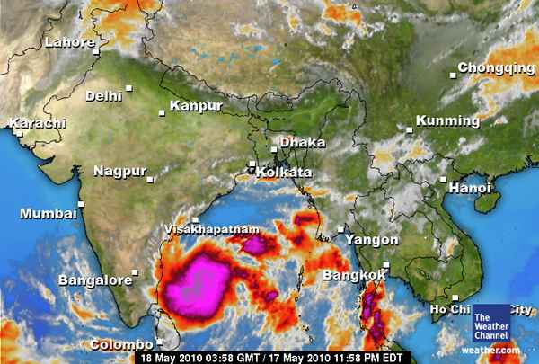
A huge wave of climbers on both sides of Everest have moved to their respective Advanced Base Camps. Many have declared a summit day of May 22nd but are monitoring the weather closely. This season is beginning to look identical to 2009 when bad weather basically shut Everest down around May 23rd and eventually delayed departures from base camps by almost week due to the heavy snow. Leaders who were there last year want to avoid a repeat, try especially on summit night. Mountain Trip, led by Scott Woolums with climbers Cindy Abbott and Paul & Denise Fejtek are looking at this weekend but have not pinned down a summit date. They explain: We are still confident that the decrease in winds forecast over the 22, 23, 24 will hold a good summit day for us. But we also have our Quiji board, tarot cards and our lucky dice! We are not being elusive with exactly when we are going, its just as the date gets closer, the forecasts become much more accurate. To say we are going say on the 24th would be reckless as things are changing rapidly by the day. One factor that will play a big role over the next week is a large tropical depression that’s formed in the Bay of Bengal and basically is heading our way. We may see precip and cloud from this as early as the 21st. This is the same type of storm that shut the mountain down last year with a lot of snow! Way to early to predict what will happen with this, but we are watching closely. On the north, an identical situation. Gabriel Filippi made this plan: I am getting ready for the summit push. I will leave around noon, and climb to camp 1 (7100m) hoping for the weather to hold. Strong winds are in the forecast until Friday night, and snow moves in on Saturday. Therefore, I am aiming to be at the last camp for the very small window during the night of the 21 to the 22, where no wind and no snow are expected. Clearly, things can change fast on a mountain, and the very notion of prediction is almost ironic. I will stay alert…. and optimistic! Looking at the weather that is playing a huge role in summit plans; IMG’s Eric Simonson posted this update on their blog that a monsoon in the Bay of Bengal is forming and moving north towards Everest. Eric posted: We are tracking tropical cyclone Laila in the Bay of Bengal. Our longtime IMG weather forecaster Michael Fagin (www.everestweather.com) forwards us this satellite photo (courtesy of Meteorological Forecasting Division, Government of Nepal). As this storm moves north, we are hoping it will be pushed east by the jet stream, missing the Everest area! So we might see a rush to the top similar to last year, 2009. Regular followers will remember that Himex actually sent their team up a bit before schedule to miss the heavy stuff. Summit night of May 22, 2009 was a tough one with stiff winds and snowfall. Dave Hahn commented last year on his summit night as the cyclone brought huge changes to Everest (remember this was 2009, not this year): We passed the other climbing teams, one by one, as we went up the face in the night and just as dawn was beginning to the East we overtook a final team at 28,000 ft and felt fully in control of our pace and destiny as we took on the South Summit. As daylight came on, I knew it was one of the prettiest mornings I’d seen from up high. But I didn’t reach for my camera. The morning was pretty because there were clouds at many levels and in many directions. I didn’t take pictures for the same reason I wouldn’t if I saw a large tiger coming my way with fangs barred. It was clear that our good weather window was closing and we needed to move fast and hard if we wanted to squeeze in a summit. We felt the full force of the winds as we crested the South Summit, but all were strong and all nodded their heads when I pointed across the crazy traverse topping the Kangshung and Southwest Faces and leading to the Hillary Step and the summit. We went for it, but even before we’d scrambled up the Hillary Step, clouds had covered the mountaintop. Visibility was poor at 6:45 AM when we stepped up to the summit. Most of us kept our packs on, knowing our stay would be short. It was not a day for photos and flags… just a few handshakes and hugs and we were out of there. We made quick time back down through the storm to high camp. Lucky. You can read Dave’s excellent description of how the cyclone’s impact hit Base Camp last year. Of course it can snow all it wants once the climbers are down! Many teams on the south are looking to start their summit bid on Friday, May 21s which would have them on top Saturday morning, May 22nd between 6:00 AM to 10:00AM, normally. Apa Sherpa 21st Chad Kellogg 22nd Jordan Romero May 23rd Alpine Ascents 22nd Adventure Consultants-22nd Altitude Junkies 22nd IMG 22nd, 23rd Adventure Dynamics 23rd 7 Summits Club 22nd, 23rd The only team still holding their cards close to their vest is Himex which is normal operating procedure for them. You can see the latest radar image for Cyclone Laila aka 01B through this link that the feeder bands are approaching Nepal. It is not time to worry, but it is time to pick up the pace a bit. Climb On! Alan
Reading Everest Weather
More teams have made the decision for a summit bid this weekend. The latest include the Malta Everest team, half of Peak Freaks and a two person team from First Ascent. They are now at camp 2. Why are these climbers going to the top in marginal weather? Well maybe the weather will not be marginal – at least according to some weather forecasts. Before looking at the weather, an quick update on the teams. There is movement on the north perhaps to fix the rope to the summit. On the south, the vast majority of the teams have chosen to wait for a longer weather window and the teams at C2 are resting up and waiting for the winds to calm before going higher. Most top teams pay for a professional weather forecast. These are teams of meteorologists who not only look at the data but also interpret it and then communicate the forecast and recommendations to their members. Climbers pay for these services and keep them private since it is a value to their team members and a safety issue.
Predicting Everest Weather: Art or Science?
As regular followers of Everest climbs know, the weather is the make/break factor for all expeditions. And the forecasts are critical for the safety of teams. While it may seem straightforward given the success rate we see in modern times, predicting the weather is far from a science as this interview with Michale Fagin shows.