 A trick question, I know! In all seriousness there are no “easy” routes up Everest, search just degrees of difficulty.
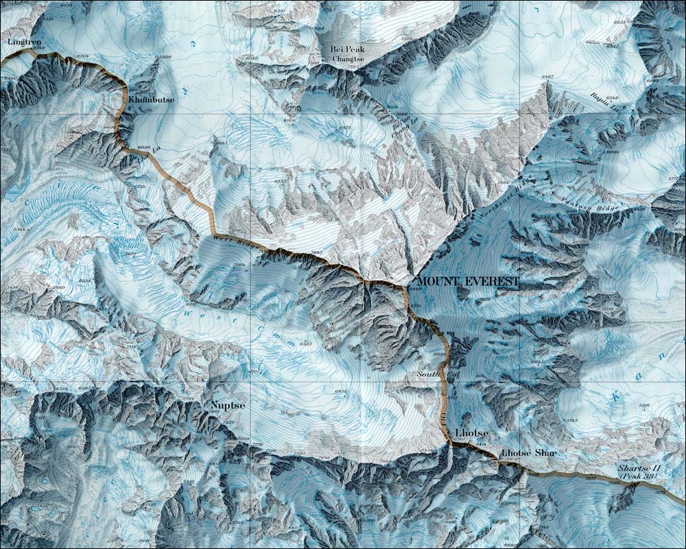
The so-called normal or standard routes are along the Southeast and Northeast Ridges via their respective Cols (click on the map to see the ridges). These are considered the most straightforward climbs that present the least amount of technical difficulty. But nothing is easy at those altitudes.
Since Everest was first attempted in 1921, there have been many attempts and over 3500 successful individual summits along a variety of routes, 21 in total.
Only two new routes on Everest have been opened since 1996: the North-Northeast couloir in 1996 by Russians Kuznetzov, Kohanov, Semikolenkov and in 2009 along the east side of the Southwest Face by a Korean team lead by legendary Park Young-seok.
There are rumors of a new route attempt for 2013 by Denis Urobko and Alexei Bolotov. They are looking at the Southeast Face starting from the Western Cwm.
However, none of the new routes have been easy. In addition to the pure climbing challenges, a vast assortment of political difficulties, wars, and rules have stopped and started climbers for almost 100 years. This is a limited timeline with a few highlights:
The Survey Expeditions
- 1841: Sir George Everest notes the location of Everest during a survey from India
- 1846: Nepal closes borders to foreigners
- 1850’s: Tibet closes borders to foreigners
- 1856: Andrew Waugh finishes Sir Everest’s survey calculating Everest to be 8840 meters (29,002 feet) high
- 1907: British reconnaissance into Nepal maps Dudh Kosi valley to end of Khumbu Glacier
- 1913: British operates a clandestine reconnaissance into Tibet reaching within 60 miles of Everest
- 1914 – 1918: World War I
- 1921: Nepal allows one limited British exploratory party to Everest region with George Mallory declaring “…I do not much fancy it would be possible…”
The First Attempts from Tibet
- 1920: The Dalai Lama opens Tibet to foreigners
- 1921 – 1938: Seven British attempts, all from Tibet, including the mysterious 1924 Mallory/Irvine expedition
- 1922: Seven Sherpas killed in an avalanche below the North Col. First recorded deaths on Everest
- 1939 – 1945: World War II
- 1950: China closes Tibetan borders after invading Tibet
The First Summit and Nepal Expeditions
- 1950: Nepal opens borders to foreigners after China closes it’s borders
- 1951: Briton Eric Shipton’s expedition develops route to top of Khumbu Icefall
- 1952: Swiss teams attempt South Col route reaching 8500 meters
- 1953: First Everest summit via South Col Route (Hillary/Norgay)
- 1959: The Dalai Lama flees Tibet for sanctuary in India
- 1960: Chinese summit via North Ridge with team of 214 men and women (Wang Fuzhou, Qu Yinhau, Gingbu)
- 1963: West Ridge via Western Cwm with descent along Southeast Ridge – first Traverse (Tom Hormbein and Willi Unsoeld)
- 1975: Southwest Face (Scott, Haston)
An Explosive Time for Summits and New Routes
- 1978: First summit without supplemental oxygen (Messner, Habeler via Southeast Ridge)
- 1979: China opens Tibet to foreigners
- 1979: West Ridge Complete with descent via Hornbein Couloir (Stremfeli, Zaplotnik)
- 1980: Reinhold Messner solo, without supplemental oxygen climb of the North Face
- 1980: North Face, North Col – North Ridge – North Face, South Pillar
- 1981: South Col Couloir – South Pillar – Southeast Ridge
- 1982: Southwest Pillar (Myslovski, Balyberdin)
- 1983: East Face – SE Ridge (Reichardt, Momb, Buhler)
- 1984: North Face via Norton Couloir (Macartney-Snape, Mortimer), North Wall (Ershler solo)
- 1985: Tibet – Nepal border opened for travel to foreigners
- 1986: West Ridge complete from Tibet
- 1988: East Kangshung Face (Venables)
- 1991: North Face (E Part to Norton Couloir)
Commercialization Begins
- 1993: Nepal limits expedition to four/year with limited numbers and high permit fees
- 1995: Nepal allows more expeditions but keeps high permit fees
- 1995: NE Ridge complete
- 1996: The largest number of deaths in one day -3 north, 5 south; 15 deaths that year
- 1996: North-Northeast couloir (Kuznetzov, Kohanov, Semikolenkov)
- 2004: Central North Face – NE ridge (Kozlov)
- 2008: China effectively closes Tibet for Everest Olympic torch climb that year
- 2009: Southwest Face (east side) (Jan-chang, Ki-seok, Dong-min, Park Young-seok)
- 2009: China allows Everest climbers but sporadically delays boarder crossings in following year
- 2010: China sets climber age limits: 18 and 60 (Nepal only has minimum age of 16)
Sources: Wikipedia, EverestHistory.com, MountEverest.net , 8000er.com, Himalayan Database
An in-Depth Look at Both Sides of Everest
A strong trend until 2007, was for more climbers to choose the north due to lower costs. But the Chinese effectively closed the north in 2008 for their Olympic torch climb and then in 2011, they increased the permit costs plus added more restrictions as to the use of Nepalese Sherpas and porters.
For 2013 the total cost is about the same as for the south for a reputable commercial guided climb. See my recent post on “How much does it cost to climb Everest?“. That said, the north continues to attract climbers due to the history, less crowding and the appeal of Tibet.
I am often asked which side is safer and my answer is pick your poison. The south has the Khumbu Icefall and the north has the Steps and weather.
The north side fatality rate is higher than the south with falls, altitude issues and exhaustion noted as the primary reasons. However the spread narrowed in 2012 with the deaths of 8 south side climbers. In spite of the Icefall dangers, I think most operators will say the south side is slightly safer and maybe a bit easier.
As I recently explained in my post “Bodies on Everest“, I wanted to examine the true statistics behind Everest deaths in the past decade and looked to research for some facts. Based on his tables and my updates, this is the summary from 2001 to 2012:
| Reason | Northeast Ridge | Southeast Route | Other Routes |
| Fall | 8 | 5 | 1 |
| Altitude | 9 | 6 | 1 |
| Exhaustion | 9 | 1 | 1 |
| Unknown | 7 | 2 | 1 |
| Avalanche | 1 | 3 | 2 |
| Crevasse | 0 | 4 | 0 |
| Exposure | 4 | 0 | 0 |
| Heart/Stroke | 1 | 4 | 0 |
| 39 | 25 | 6 |
[poll id=”5″]
There will almost always be deaths on Everest, that is the nature of high-altitude mountaineering. But the real story is the role and impact of the unsung heroes – the Sherpas. They have suffered 13 deaths the past 12 years almost all on the south side from falls, avalanches and crevasse accidents.
With this background, let’s take a brief look at their pros and cons:
South Col Route
| Pluses | Concerns |
| Beautiful trek to base camp in the Khumbu | Khumbu Icefall instability |
| Easy access to villages for pre-summit recovery | Crowds, especially on summit night |
| Helicopter rescue from base camp if necessary | Cornice Traverse exposure, SE Ridge Slabs |
| Slightly warmer sometimes with less winds | Slightly longer summit night |
Northeast Ridge Route
| Pluses | Concerns |
| Less crowds | Colder temps and harsher winds |
| Can drive to base camp | Camps at higher elevations |
| Easier climbing to mid-level camps | A bit more difficult with smooth or loose rocks |
| Slightly shorter summit night | No opportunity for helicopter rescue at any point |

Southeast Ridge Route
Mt. Everest was first summited by Sherpa Tenzing Norgay and New Zealander Edmond Hillary with a British expedition in 1953. They used the South Col route. At that time the route had only been attempted twice by Swiss teams in the spring and autumn of 1952. They reached 8500m well above the South Col. Of note, Norgay was with the Swiss thus giving him the experience he used on the British expedition. The Swiss returned in 1956 to make the second summit of Everest.
Here is a typical south side climb schedule showing average time and the distance from the previous camp plus a brief description of each section. More details can be found on the South Col route page.
- Base camp: 17,500?/5334m
- Home away from home. Located on a moving glacier, tents can shift and platforms melt. The area is harsh but beautiful surrounded by Pumori and the Khumbu Icefall with warm mornings and afternoon snow squalls. With so many expedition tents, pathways and generators, it feels like a small village, some would say a crowded bar!.
- C1: 19,500?/5943m – 4-6 hours, 1.62 miles
- Reaching C1, is the most dangerous part of a south climb since it crosses the Khumbu Icefall. The Icefall is 2,000? of moving ice, sometimes as much as 3 feet a day. But it is the deep crevasses, towering ice seracs and avalanches off Everest’s West shoulder that creates the most danger.
- C2: 21,000?/6400m – 2-3 hours, 1.74 miles
- The trek from C1 to C2 crosses the Western Cwm and can be laden with crevasse danger. But it is the extremely hot temperatures that takes a toll on climbers. Again avalanche danger exist from Everest’s West Shoulder that has dusted C1 in recent years.
- C3: 23,500?/7162m – 3-6 hours, 1.64 miles
- Climbing the Lhotse Face to C3 is often difficult since almost all climbers are feeling the effects of high altitude and are not yet using supplemental oxygen. The Lhotse Face is steep and the ice is hard. The route is fixed with rope. The angles can range from 20 to 45 degrees. It is a long climb to C3 but is required for acclimatization prior to a summit bid.
- Yellow Band – 3 hours
- The route to the South Col begins at C3 and across the Yellow Band. It starts steep but settles into a sustained grade as the altitude increases. Climbers are usually in their down suits and are using supplemental oxygen for the first time. The Yellow Band’s limestone rock itself is not difficult climbing but can be challenging given the altitude. Bottlenecks can occur on the Yellow Band.
- Geneva Spur – 2 hours
- This section can be a surprise for some climbers. The top of the Spur leading onto the South Col has some of the steepest climbing thus far. It is easier with a good layer of snow than on the loose rocks.
- South Col: 26,300?/8016m – 1 hour or less
- Welcome to the moon. This is a flat area covered with loose rock and surrounded by Everest to the north and Lhotse on the south. Generally, teams cluster tents together and anchor with nets or heavy rocks against the hurricane force winds. This is the staging area for the summit bids and the high point for Sherpas to ferry oxygen and gear for the summit bid.
- Balcony: 27,500?/8400m- 4 – 5 hours
- Officially now on Everest, climbers are using supplemental oxygen to climb the steep and sustained route up the Triangular Face. The route is fixed with rope and climbers create a long conga line of headlamps in the dark. The pace is maddeningly slow complete with periods of full stop while climbers ahead rest, consider the decision to turn back or continue to the balcony. It can be rock or snow depending on the year. Rock fall can be an deadly issue and most climbers now use helmets. They swap oxygen bottles at the Balcony while taking a short break for some food and water.

- South Summit : 28500?/8690m – 3 to 5 hours
- The climb from the Balcony to the South Summit is steep and continuous. While mostly on a beaten down boot path, it can be challenging near the South Summit with exposed slabs of smooth rock in low snow years. The views of Lhotse and the sun rising to the east is indescribable at this point. Climbers lose radio contact with EBC in this section.
- Hillary Step – 1 hour or less
- One of the most exposed sections of a south side climb is crossing the cornice traverse between the south summit and the Hillary Step. But the route is fixed and wide enough that climbers rarely have issues. The Hillary Step is a short 40? section of rock climbing, again fixed with rope, that creates a bottleneck on crowded summit nights. Sometimes there is an up and down climbing rope to keep people moving.
- Summit: 29,035?/8850m – 1 hour or less
- The last section from the Hillary Step to the summit is a moderate snow slope. While tired, climber’s adrenaline keep them going.
- Return to South Col: 4 -7 hours
- Care must be taken to avoid a misplaced step down climbing the Hillary Step, the Cornice Traverse or the slabs below the south summit. Also diligent monitoring of oxygen levels and supply is critical to make sure the oxygen lasts back to the South Col.
- Return to C2: 3 hours
- Usually climbers are quite tired but happy to be returning to the higher natural oxygen levels regardless of their summit performance. It can be very hot since most climbers are still in their down suits.
- Return to base camp: 4 hours
- Packs are heavy since everything they hauled up over the preceding month must be taken back down. It is now almost June so the temperatures are warmer making the snow mushy thus increasing the difficulty. But each step brings them closer to base camp comforts and on to their home and families.
For a more detailed description, please see the South Col route page. Also, here is my animated map of climbing the South Col route:

Northeast Ridge Route
The north side of Everest is steeped in history with multiple attempts throughout the 1920’s and 1930’s. The first attempt was by a British team in 1921. Mallory led a small team to be the first human to set foot on the mountains flanks by climbing up to the North Col (7003m). The second expedition, in 1922 reached 27,300? before turning back, and was the first team to use supplemental oxygen. It was also on this expedition that the first deaths were reported when an avalanche killed seven Sherpas.
The 1924 British expedition with George Mallory and Andrew “Sandy” Irvine is most notable for the mystery of whether they summited or not. If they did summit, that would precede Tenzing and Hilary by 29 years. Mallory’s body was found in 1999 but there was no proof that he died going up or coming down.
A Chinese team made the first summit from Tibet on May 25, 1960. Nawang Gombu (Tibetan) and Chinese Chu Yin-Hau and Wang Fu-zhou, who is said to have climbed the Second Step in his sock feet, claimed the honor. In 1975, on a successful summit expedition, the Chinese installed the ladder on the Second Step.
Tibet was closed to foreigners from 1950 to 1980 preventing any further attempts until a Japanese team summited in 1980 via the Hornbein Couloir on the North Face.
The north side started to attract more climbers in the mid 1990s and today is almost as popular as the South side when the Chinese allow permits.
Now let’s look at typical north side schedule showing average time from the previous camp plus a brief description of each section. More details can be found on the Northeast Ridge route page.
- Base camp: 17000? – 5182m
- located on a gravel area near the Rongbuk Monastery, this is the end of the road. All vehicle assisted evacuations start here. There are no helicopter rescues or evacuations on the north side or for any mountain in Tibet.
- Interim camp: 20300?/6187m – 5 to 6 hours (first time)
- Used on the first trek to ABC during the acclimatization process, this is a spot where a few tents are placed. Usually this area is lightly snow covered or none at all.
- Advanced base camp: 21300?/6492m – 6 hours (first time)
- Many teams use ABC as their primary camp during the acclimatization period but it is quite high. This area can still be void of snow but offers a stunning view directly at the North Col. It is a harsh environment and a long walk back to the relative comfort of base camp or Tibetan villages.
- North Col or C1: 23,000?/7000m – 4 to 6 hours (first time)
- Leaving Camp 1, climbers reach the East Rongbuk Glacier and put on their crampons for the first time. After a short walk, they clip into the fixed line and perhaps cross a few ladders that are placed over deep glacier crevasses. The climb from ABC to the North Col steadily gains altitude with one steep section of 60 degrees that will feel vertical. Climbers may use their ascenders on the fixed rope. Rappelling or arm-wrap techniques are used to descend this steep section. Teams will spend several nights at the Col during the expedition.
- Camp 2: 24,750?/7500m – 5 hours
- Mostly a steep and snowy ridge climb that turns to rock. High winds are sometimes a problem making this a cold climb. Some teams use C2 as their highest camp for acclimatization purposes.
- Camp 3: 27,390?/8300m – 4 to 6 hours
- Teams place their camp 3 at several different spots on the ridge since it is steep, rocky and exposed. Now using supplemental oxygen, tents are perched on rock ledges and are often pummeled with strong winds. This is higher than the South Col in altitude and exposure to the weather. It is the launching spot for the summit bid with some teams spending the night or just a few hours.
- Yellow Band
- Leaving C3, climbers follow the fixed rope through a snow filled gully; part of the Yellow Band. From here, climbers take a small ramp and reach the northeast ridge proper.
- First Step: 27890?/8500m
- The first of three rock features. The route tends to cross to the right of the high point but some climbers may rate it as steep and challenging. This one requires good foot work and steady use of the fixed rope in the final gulley to the ridge.
- Mushroom Rock -28047?/8549m – 2 hours from C3
- A rock feature that spotters and climbers can use to measure their progress on summit night. Oxygen is swapped at this point. The route can be full of loose rock here adding to the difficulty with crampons. Climbers will use all their mountaineering skills.
- Second Step: 28140?/8577m – 1 hour or less
- This is the crux of the climb with the Chinese Ladder. Climbers must first ascend about 10? of rock slab then climb the near vertical 30? ladder. This section is very exposed with a 10,000? vertical drop. It is more difficult to navigate on the decent since you cannot see your feet placement on the ladder rungs. This brief section is notorious for long delays thus increasing the chance of frostbite or AMS.
- Third Step: 28500?/8690m – 1 to 2 hours
- The easiest of the three steps but requires concentration to be safe.
- Summit Pyramid – 2 to 4 hours
- A steep snow slope, often windy and brutally cold, climbers feel very exposed at this point. Towards the top of the Pyramid, climbers are extremely exposed again as they navigate around a large outcropping and experience three more small rock steps on a ramp before the final ridge climb to the summit.
- Summit: 29,035?/8850m – 1 hour
- The final 500? horizontal distance is along the ridge to the summit is quite exposed. Slopes angles range from 30 to 60 degrees.
- Return to Camp 3: – 7 -8 hours
- The down climb takes the identical route. Early summiters may experience delays at the 2nd Step with climbers going up or summiters having down climbing issues.
- Return to ABC: 3 hours
- Packs can be heavy since everything hauled up over the preceding month must be taken back down. It is now almost June so the temperatures are warmer. But each step brings them closer to base camp comforts and on to their home and families.
For a more detailed description and route pictures, please see the Northeast Ridge route page. Also, here is my animated map of climbing the Northeast Ridge route:
Summary
How do the routes on Everest compare with other large mountains? There are about 10 on K2, the second highest mountain and 11 on Annapurna. For lower popular mountains the routes can be in the hundreds.
A new route on any 8000m mountain requires enormous skills, courage and luck. For example one of the most coveted new routes was the Mazeno Ridge on the world’s ninth highest peak, Nanga Parbat at 8126m. Sandy Allan and Rick Allen who summited alone via the never before completed route taking over 13 days in 2012. A serious climbing achievement.
Climb On!
Alan
Memories are Everything
Hey Alan,
Wow. nice work on that post. Does pretty much every climber on the north side drive up to base camp or is there a trek?
Thanks,
Zachary Zaitzeff
Thanks Zach. Yes, everyone drives to the so called Chinese Base Camp. There is no trek like on the south side. I guess it is possible but would require permits from the Chinese, etc.
Thanks Alan. What is the elevation gain during the drive? One of the many awesome things about the trek on the south side is that you can take your time and acclimate well to the higher altitude. I would think that driving to base camp, one would have a tougher time acclimatizing. One of the worst nights of my life was when I did Cayumbe in Equador. We drove up to that lodge at about 17,000 feet and it was such misery. Sure. We did a few acclimatization hikes beforehand but it was still brutal….
The standard schedule takes up to a week to drive from Kathmandu (4600′), a bit less from Lhasa (12,000′), stopping at small villages along the way to acclimatize and to do easy day hikes to 15K or 16K. Climbers never drive straight through for the reasons you mention. Once at BC (17k), you spend another few days adjusting before starting the climb.
thanks Alan
Absolutely fascinating read, Alan, thank you.
What a great article Alan! Some great information on both routes, well done. If I had the chance/health/money I would choose the North route and follow in Mallory’s footsteps!
Mount Everest Facts
Fantastic job Alan…lots of information and so well done. Taking my wife on the Everest Base Camp trek this year with the IMG Classic climbers and really looking forward to it. Just got back from the South Pole….cold…burrrrr!!!
Climb on “one day at a time,”
John Dahlem
🙂
get well alan!! I would love to climb with you one day!
HA HA HA!!! Get well! Cannot wait for this season’s coverage!!! I miss the mountains. never knew how much they would become part of me in one trip over there!
i am!
Shouldn’t you be languishing in a bed loaded on Lortab?
I can see that NOTHING keeps you down! Way to go, my friend! 🙂